Summary ![]()
| Difficulty | 1-5 Beginner through advanced |
| Length | Up to 27.6 miles one-way to Southwest Entrance |
| Starting Elevation |
5900 feet |
| Cumulative Elevation Change |
Up to +3200, -2400 one-way to Kohm Yah-mah-nee Visitor Center located one mile north the Southwest Entrance Station |
| Navigation | Road and map |
| Time | Few hours to few days |
| Season | December through April |
| Snowmobiles Use | Not permitted [Please report illegal use of snowmobiles in this area.] |
| USGS Topo | 7.5' series, Lassen Peak, Reading Peak, West Prospect Peak, Manzanita Lake |
| Start | Manzanita Lake Ranger Station off Highway 44. |
| End | Same as starting point or Kohm Yah-mah-nee Visitor Center located one mile past the Southwest Entrance Station. |
Description ![]()
This tour is a reverse of the Lassen Park Road From Southwest Entrance tour. Starting from the Manzanita Lake Ranger Station you will find gentle terrain and fewer skiers than at the southwest entrance. Also, starting from the Manzanita Lake end there is less avalanche danger on the road unless you are planning to ski beyond Kings Creek (16.6 miles). Refer to the tour from the southwest entrance for additional information related to the hazards you will encounter beyond Kings Creek.
A ski tour on Lassen Park Road starting from the Manzanita Lake Ranger Station can be a very pleasant experience. After passing through Chaos Jumbles at the base of Chaos Crags, you reach a high point 1.2 miles from the start. Beyond the high point the road descends for 1.1 miles to Sunflower Flat and the junction with the Nobles Trail. You can ski a loop by combining a tour on the park road with the Nobles Trail tour.
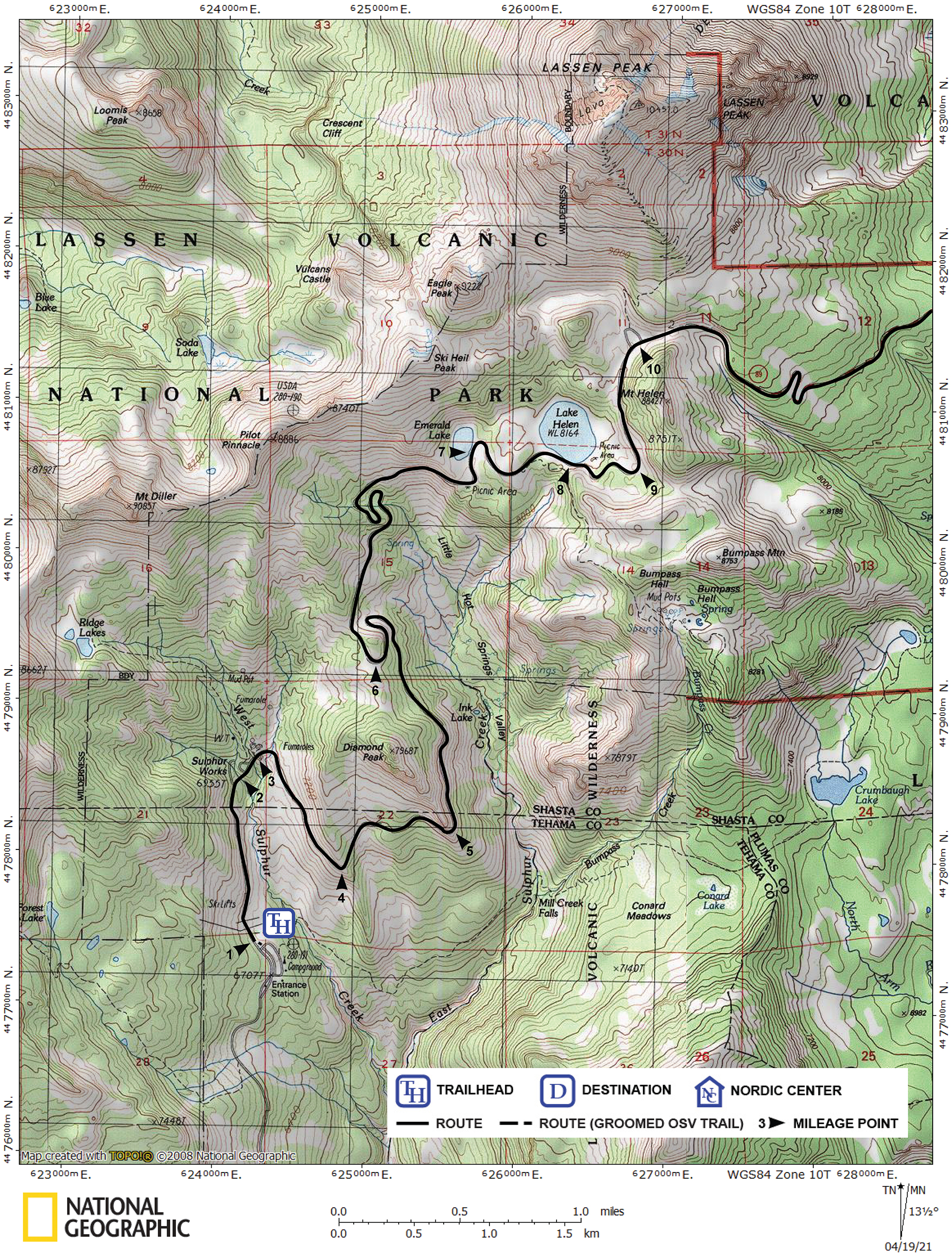
Mileage Log ![]()
Numbers in parentheses
correspond to mileage points on map
Waypoint 22 to 21
Miles: 0.0 - 1.1
Elevation change: +300
From the trailhead (22) ski east and then northeast on Lassen Park Road for 1.1 miles until you reach a high point (21). In this section you will ski through Chaos Jumbles.
Waypoint 21 to 20
Miles: 1.1 - 2.2
Elevation change: -150
Ski northeast on Lassen Park Road for 1.1 miles until you reach the junction with the Nobles Trail (20) at Sunflower Flat. There is no landmark at this location. The Nobles Trail tour is described separately in this guide.
Waypoint 20 to 19
Miles: 2.2 - 3.3
Elevation change: -300
Ski north on Lassen Park Road for 1.1 miles until you reach the location where the road makes a sharp (right) turn (19) and then heads southeast.
Waypoint 19 to 18
Miles: 3.3 - 6.5
Elevation change: +450, -100
Ski southeast on Lassen Park Road for 3.2 miles until you reach the location where the road crosses Lost Creek (18).
Waypoint 18 to 17
Miles: 6.5 - 8.9
Elevation change: +400
Ski southeast on Lassen Park Road for 2.4 miles until you reach Emigrant Pass (17).
Waypoint 17 to 16
Miles: 8.9 - 9.3
Elevation change: -50
Ski south on Lassen Park Road for 0.4 mile until you reach the West Fork of Hat Creek (16). At Hat Creek the Paradise Meadow Cutoff intersects the road. Although Hat Lake is shown on some maps, sedimentation has completely filled it in.
Waypoint 16 to 15
Miles: 9.3 - 11.7
Elevation change: +250
Ski southeast on Lassen Park Road for 2.4 mile until you reach the Summit Lake Ranger Station (15). The ranger station is off the road to the northeast (left).
Waypoint 15 to 14
Miles: 11.7 - 12.1
Elevation change: +0
Ski south on Lassen Park Road for 0.4 mile until you reach Summit Lake (14). At this point the Terrace Lake-Shadow Lake Cutoff intersects the road.
Waypoint 14 to 13
Miles: 12.1 - 16.1
Elevation change: +700, -50
Ski south and then gradually turn west on Lassen Park Road for 4.0 miles until you reach Upper Meadow (13).
Waypoint 13 to 12
Miles: 16.1 - 16.6
Elevation change: +100
Ski northwest on Lassen Park Road for 0.5 mile until you reach Kings Creek Picnic Area (12). Although the road into the picnic area will not be visible, the sign for the turnoff may be. The Lake Helen Cutoff intersects the road here.
Waypoint 12 to 11
Miles: 16.6 - 19.0
Elevation change: +600
Ski north, east and then northwest on Lassen Park Road for a total of 2.4 miles until you reach the Terrace Lake Trailhead (11) that is located at the base of Reading Peak's west ridge. The trailhead is the turnoff point for the Terrace Lake-Shadow Lake Cutoff and the Paradise Meadow Cutoff.
Waypoint 11 to 10
Miles: 19.0 - 20.8
Elevation change: +400
Ski generally west on Lassen Park Road for 1.8 miles until you reach the Lassen Peak Trailhead (10). The flat area is the start of the steep ascent of Lassen Peak and the Crescent Cliff Traverse tour intersects Lassen Park Road here.
Waypoint 10 to 9
Miles: 20.8 - 21.4
Elevation change: -150
Ski south on Lassen Park Road for 0.6 mile until you reach the location where the road turns west (9). The turn in the road is the turnoff point for the Bumpass Hell tour and the start of the Lake Helen Cutoff tour, which shortens the tour on the park road by 3.1 miles.
Waypoint 9 to 8
Miles: 21.4 - 21.7
Elevation change: -150
Ski generally west on Lassen Park Road for 0.3 mile until you reach Lake Helen (8).
Waypoint 8 to 7
Miles: 21.7 - 22.3
Elevation change: -50
Ski west on Lassen Park Road for 0.6 mile until you reach Emerald Lake (7). If you lose sight of the road, ski west to Emerald Lake where you will be able to pick up the road again.
Waypoint 7 to 6
Miles: 22.3 - 24.1
Elevation change: -500
Ski generally west on Lassen Park Road for 0.7 mile until you reach the start of an S-turn, then ski 0.3 mile through the S-turn, and finally ski south for 0.8 mile until you reach Diamond Peak Saddle (6). The saddle is the start of an S-turn where the road travels along a ridge-like area. The Sulphur Works Cutoff intersects the road 0.1 mile before reaching Diamond Peak Saddle.
Waypoint 6 to 5
Miles: 24.1 - 25.5
Elevation change: -350
Ski north for 0.3 mile to a 180 degree turn in Lassen Park Road and then south for 1.1 miles until you reach Diamond Point (5). Diamond Point affords a good view to the southeast of the Mill Creek drainage and Mt. Conard.
Waypoint 5 to 4
Miles: 25.5 - 26.1
Elevation change: -150
Ski generally west on Lassen Park Road for 0.6 mile until you reach Brokeoff Mountain Viewpoint (4). The viewpoint, also called Windy Point, offers an excellent view to the west of Brokeoff Mountain, the largest remaining part of Mt. Tehama, an 11,000-foot volcano.
Waypoint 4 to 3
Miles: 26.1 - 26.8
Elevation change: -150
Ski northwest on Lassen Park Road for 0.7 mile until you reach the Sulphur Works (3). At the Sulphur Works, an active hydrothermal area, you can hike the short nature trail (boardwalks) located on the north (right) side of the road. This is one end of the Sulphur Works Cutoff tour, which shortens the tour along Lassen Park Road by 2.1 miles and bypasses the portion of Lassen Park Road east of Diamond Peak that is prone to avalanche.
Waypoint 3 to 2
Miles: 26.8 - 26.9
Elevation change: -50
Ski southwest on Lassen Park Road for 0.1 mile until you reach the bridge (2) across West Sulphur Creek. The bridge is the turnoff point for the Ridge Lakes tour.
Waypoint 2 to 1
Miles: 26.9 - 27.6
Elevation change: -200
Ski south on Lassen Park Road for 0.7 mile until you reach the Kohm Yah-mah-nee Visitor Center (1).