Summary ![]()
| Difficulty | 4 Intermediate-advanced |
| Length | 0.7 mile one-way |
| Starting Elevation |
7000 feet |
| Cumulative Elevation Change |
+650 one-way |
| Navigation | Map and compass |
| Time | Short |
| Season | December through April |
| Snowmobiles Use | Not permitted [Please report illegal use of snowmobiles in this area.] |
| USGS Topo | 7.5' series, Lassen Peak |
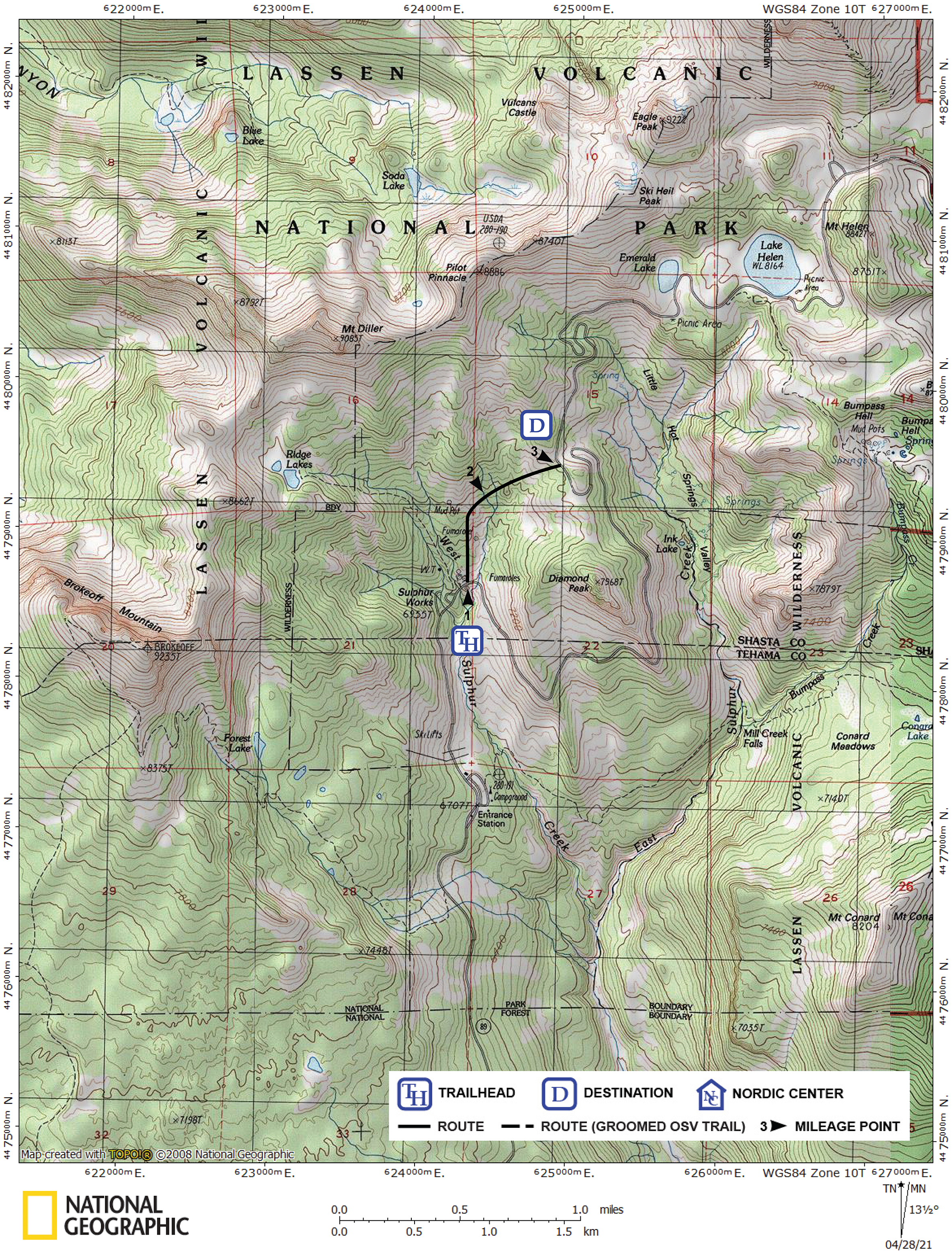
| Start | Snow-covered Lassen Park Road at the Sulphur Works, which is located 0.8 mile beyond the Kohm Yah-mah-nee Visitor Center. |
| End | Snow-covered Lassen Park Road 0.1 mile north and beyond Diamond Peak Saddle. This point is 3.6 miles from the Kohm Yah-mah-nee Visitor Center via the road.. |
Description ![]()
The main feature of the 0.7 mile long Sulphur Works Cutoff is that it shortens a tour on Lassen Park Road by 2.1 miles. This feature is of particular interest to those skiers who wish to explore points beyond Lake Helen in a single day. In exchange, you must negotiate steeper terrain and navigate without the security of a road.
The Sulphur Works Cutoff can also be used to create a small loop tour as described in the Sulphur Works Cutoff Loop tour and add some variation to an otherwise straightforward tour on Lassen Park Road. In periods of unstable conditions, the cutoff is useful because it bypasses the portion of Lassen Park Road east of Diamond Peak which is prone to avalanche. However, use of the cutoff does not assure complete safety from avalanches.
The cutoff begins at the Sulphur Works on the north (left) side of Lassen Park Road just beyond a large steam vent on the south (right) side of the road. This point is west (before) the North Fork of West Sulphur Creek.
Mileage Log ![]()
Numbers in parentheses
correspond to mileage points on map
Waypoint 1 to 2
Miles: 0.0 - 0.4
Elevation change: +350
From the Sulphur Works (1) ski north from Lassen Park Road for 0.4 mile until you reach the location where you cross the North Fork of West Sulphur Creek (2).
Waypoint 2 to 3
Miles: 0.4 - 0.7
Elevation change: +300
Continue to climb north of east for 0.3 mile until you reach Lassen Park Road (3) at a point 0.1 mile north of Diamond Peak Saddle.