Summary ![]()
| Difficulty | 4 Intermediate-advanced |
| Length | 2.6 miles one-way |
| Starting Elevation |
8050 feet |
| Cumulative Elevation Change |
-1600 one-way |
| Navigation | Map and compass |
| Time | Few hours (half day if skied in reverse direction) |
| Season | December through April |
| Snowmobiles Use | Not permitted [Please report illegal use of snowmobiles in this area.] |
| USGS Topo | 7.5' series, Reading Peak, West Prospect Peak |
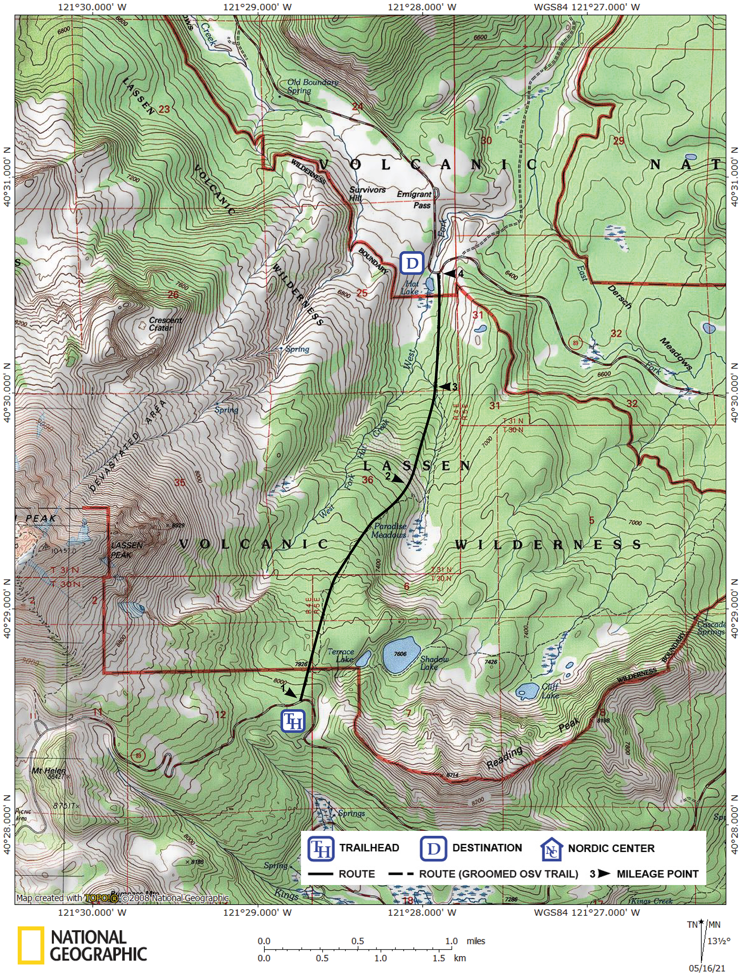
| Start | Snow-covered Lassen Park Road at the Terrace Lake Trailhead, 8.6 miles from the Kohm Yah-mah-nee Visitor Center. |
| End | Snow-covered Lassen Park Road at the West Fork of Hat Creek which is located 18.2 miles from the Kohm Yah-mah-nee Visitor Center. |
Description ![]()
The most significant feature of the 2.6 mile Paradise Meadow Cutoff is that it shortens the tour from the Kohm Yah-mah-nee Visitor Center to the Manzanita Lake Ranger Station via Lassen Park Road by 7.0 miles. If you use this cutoff, the trans-park tour is reduced to 20.6 miles, a not unreasonable distance for a spring, one-day tour for an expert skier. But most people will use this cutoff as part of a multi-day tour in the park. The Paradise Meadow Cutoff can also be combined with the Terrace Lake-Shadow Lake Cutoff tour and a section of the Lassen Park Road to make a loop tour.
This tour does not actually go to Paradise Meadow though time permitting you could make a side trip to visit it.
The difficulty rating of this tour is based predominantly on the need to navigate with a map and compass. Although the Paradise Meadow Cutoff is a steeper descent than the Terrace Lake-Shadow Lake Cutoff, it is less wooded. There are still two obstacles on this route. Just below Paradise Meadow the skiing is made difficult by dense woods and steep terrain. The other obstacle is the need to cross the tributary from Paradise Meadow that enters the West Fork of Hat Creek.
Mileage Log ![]()
Numbers in parentheses
correspond to mileage points on map
Waypoint 1 to 2
Miles: 0.0 - 1.4
Elevation change: -1000
Ski slightly east of north and then northeast for a total of 1.4 miles until you reach a point north of Paradise Meadow (2). If you are too far east you will find yourself in steep terrain above Paradise Meadow.
Waypoint 2 to 3
Miles: 1.4 - 1.9
Elevation change: -450
Ski north for 0.5 mile until you reach the tributary of the West Fork of Hat Creek (3) that originates at Paradise Meadow. In this section you may encounter dense woods. Crossing the creek may also be difficult in the spring.
Waypoint 3 to 4
Miles: 1.9 - 2.6
Elevation change: -150
Ski north for 0.7 mile until you reach Lassen Park Road (4) near the bridge across the West Fork of Hat Creek.