Summary ![]()
| Difficulty | 5 Advanced |
| Length | 16.2 miles round trip from Kohm Yah-mah-nee Visitor Center or 2.6 miles round trip from Lassen Peak Trailhead |
| Starting Elevation |
6750 feet at Kohm Yah-mah-nee Visitor Center or 8450 feet at Lassen Peak Trailhead |
| Cumulative Elevation Change |
+3700, -3700 round trip from Kohm Yah-mah-nee Visitor Center or +2000, -2000 round trip from Lassen Peak Trailhead |
| Navigation | Road, map and compass |
| Time | Two or three days from Kohm Yah-mah-nee Visitor Center or few hours from Lassen Peak Trailhead |
| Season | December through May |
| Snowmobiles Use | Not permitted [Please report illegal use of snowmobiles in this area.] |
| USGS Topo | 7.5' series, Lassen Peak |
| Start | Kohm Yah-mah-nee Visitor Center or Lassen Peak Trailhead. |
Description ![]()
At the center of the park stands monolithic Lassen Peak and its 10,457-foot summit which towers above everything else. The peak is relatively young by geologic standards, only 11,000 years, but the snow you ski on hides lava which spewed forth as recently as 1917.
Needless to say, the views from the summit on a clear day are magnificent. You will see north past Mount Shasta into southern Oregon and south to the San Francisco Bay Area.
Most travelers allow three days to summit Lassen Peak in the winter; a day to reach a basecamp, a day to climb, and a day to return to the trailhead. Skiing out the same day as the climb is also an alternative. Still another alternative is to climb immediately after Lassen Park Road is open from the southwest entrance.
The ascent is a major undertaking, especially in winter when high winds are often encountered not only on the mountain but also in the Lake Helen area.
The weather is also unpredictable and can change rapidly making the mountain unsafe. The conditions are most stable early in the morning before warming begins. The Forest Service does not recommend being on the mountain in the afternoon.
The winter route described in this tour follows Lassen Park Road to the Lassen Peak Trailhead. This route crosses avalanche terrain in several locations. Some of these can be eliminated by taking the Sulphur Works Cutoff that also reduces the length of the tour 2.1 miles in each direction.
But there is no way to bypass the avalanche slope to the southwest of Emerald Lake referred to as the Emerald Sidehill. You must traverse this slope to reach Lake Helen.
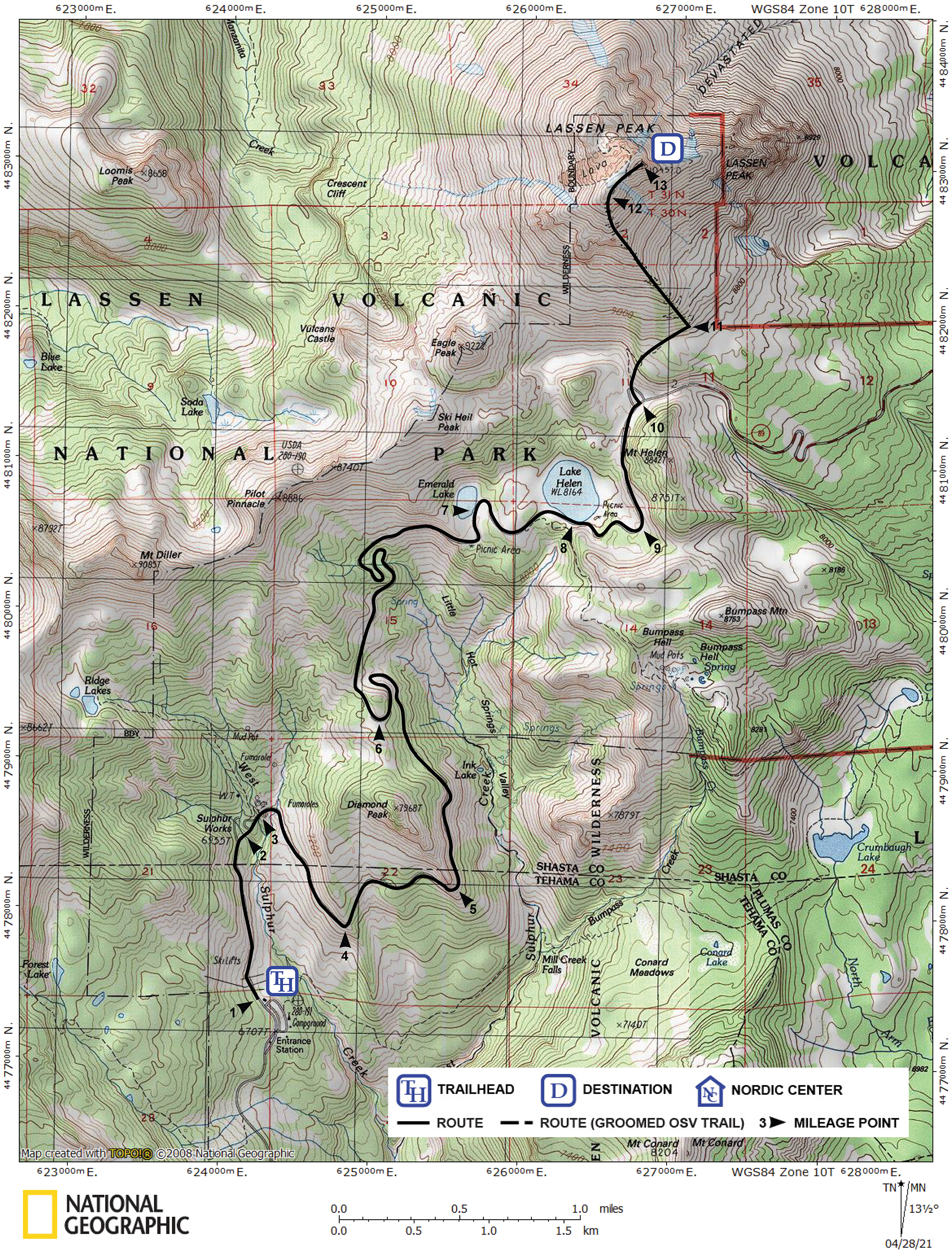
Mileage Log ![]()
Numbers in parentheses
correspond to mileage points on map
Waypoint 1 to 2
Miles: 0.0 - 0.7
Elevation change: +200
From the trailhead (1) ski north on Lassen Park Road for 0.7 mile until you reach the bridge (2) across West Sulphur Creek. The bridge is the turnoff point for Ridge Lakes tour.
Waypoint 2 to 3
Miles: 0.7 - 0.8
Elevation change: +50
Ski northeast on Lassen Park Road for 0.1 mile until you reach the Sulphur Works (3). At the Sulphur Works, an active hydrothermal area, you can hike the short nature trail (boardwalks) located on the north (left) side of the road. The Sulphur Works Cutoff tour also begins here. The cutoff shortens the tour to Emerald Lake and Lake Helen by 2.1 miles and bypasses the portion of Lassen Park Road east of Diamond Peak that is prone to avalanche.
Waypoint 3 to 4
Miles: 0.8 - 1.5
Elevation change: +150
Ski southeast on Lassen Park Road for 0.7 mile until you reach Brokeoff Mountain Viewpoint (4). The viewpoint, also called Windy Point, offers an excellent view to the west of Brokeoff Mountain, the largest remaining part of Mt. Tehama, an 11,000-foot volcano.
Waypoint 4 to 5
Miles: 1.5 - 2.1
Elevation change: +150
Ski generally east on Lassen Park Road for 0.6 mile until you reach Diamond Point (5). Diamond Point affords a good view to the southeast of the Mill Creek drainage and Mt. Conard.
Waypoint 5 to 6
Miles: 2.1 - 3.5
Elevation change: +350
Ski north on Lassen Park Road for 1.1 miles to a 180 degree turn in the road and then for 0.3 mile until you reach Diamond Peak Saddle (6). The saddle is located at the top of an S-turn where the road travels along a ridge-like area. The Sulphur Works Cutoff intersects the road 0.1 mile past here.
Waypoint 6 to 7
Miles: 3.5 - 5.3
Elevation change: +500
Ski north on Lassen Park Road for 0.8 mile until you reach the start of an S-turn, then ski 0.3 mile through the S-turn, and then generally east for 0.7 mile until you reach Emerald Lake (7). Emerald Lake is the first good snow camping site along Lassen Park Road.
Waypoint 7 to 8
Miles: 5.3 - 5.9
Elevation change: +50
Ski generally east on Lassen Park Road for 0.6 mile until you reach Lake Helen (8). If you lose sight of the road at Emerald Lake, ski east until you reach Lake Helen where you will be able to pick up the road again.
Waypoint 8 to 9
Miles: 5.9 - 6.2
Elevation change: +150
Ski generally east on Lassen Park Road for 0.3 mile until you reach the location where the road turns north (left) (9). The turn in the road is the turnoff point for Bumpass Hell tour, and the start of the Lake Helen Cutoff tour, which shortens the tour on the park road by 3.1 miles.
Waypoint 9 to 10
Miles: 6.2 - 6.8
Elevation change: +150
Ski north on Lassen Park Road for 0.6 mile until you reach the flat area that is the Lassen Peak Trailhead (10). The flat area is the start of the steep ascent of Lassen Peak and the Crescent Cliff Traverse tour intersects Lassen Park Road here.
Waypoint 10 to 11
Miles: 6.8 - 7.2
Elevation change: +500
Climb northeast, generally following the summer trail, for 0.4 mile until you reach the base of the southeast ridge (11). The ski route ascends this ridge.
Waypoint 11 to 12
Miles: 7.2 - 7.9
Elevation change: +1400
Climb northwest on the ridge for 0.7 mile to the broad summit area (12).
Waypoint 12 to 13
Miles: 7.9 - 8.1
Elevation change: +100
Ski northeast for 0.2 mile to the summit of Lassen Peak (13).
Return to the trailhead
Miles: 8.1 - 16.2
Elevation change: -3700
Retrace your route for 8.1 miles back to the trailhead (1).