Summary ![]()
| Difficulty | 1-4 Beginner to intermediate-advanced |
| Length | 3 to 17 miles |
| Starting Elevation |
7050 at Foster Meadow Road or 7350 at Iron Mountain Sno-Park |
| Cumulative Elevation Change |
Depends on route |
| Navigation | Road, marked trail and map |
| Time | Several hours to very long day |
| Season | December through mid-April |
| Snowmobiles Use | Low to high depending on route |
| USGS Topo | 7.5' series, Bear River Reservoir, Peddler Hill, Tragedy Spring and Leek Spring Hill |
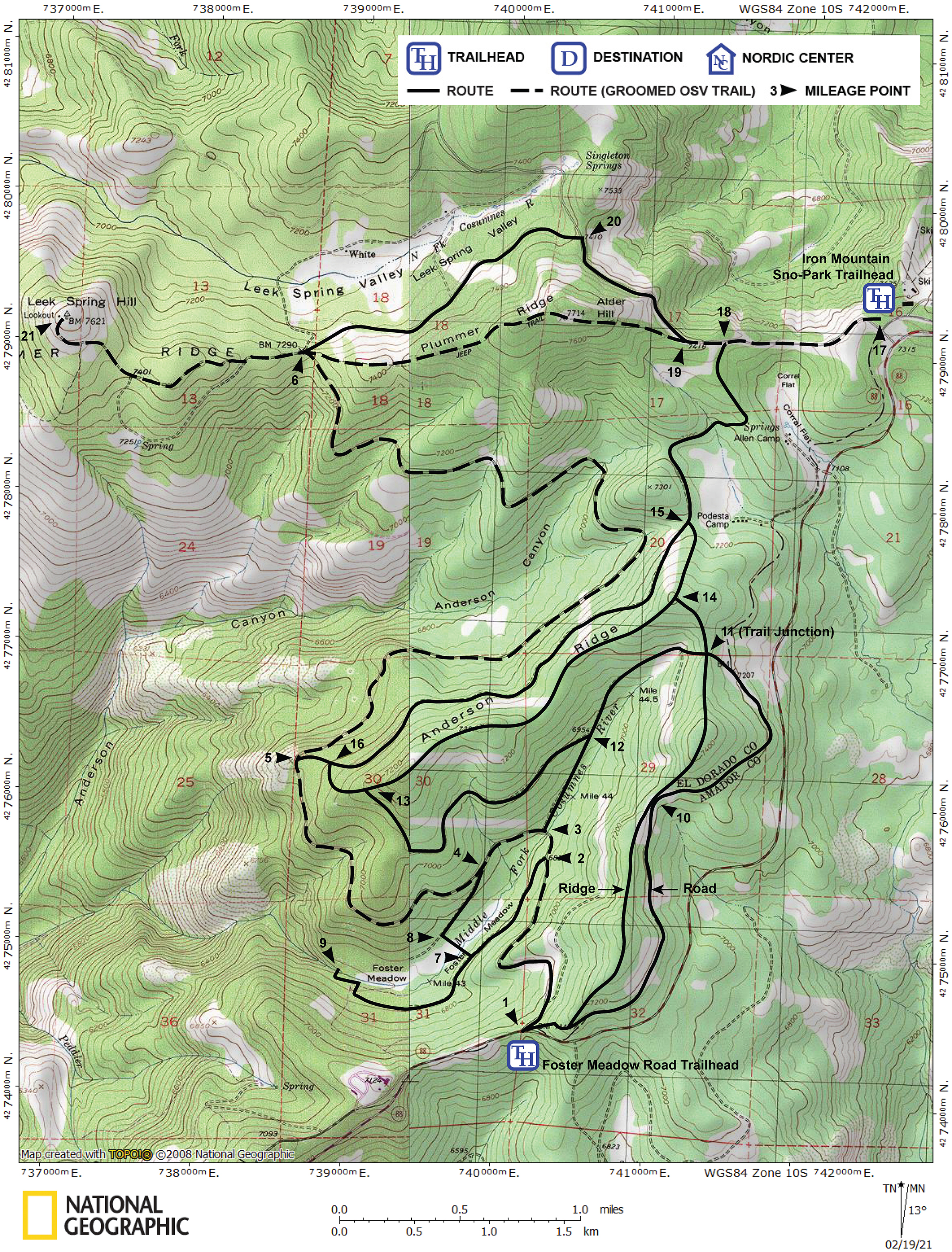
| Start | There are two trailheads for this area: Foster Meadow Road Highway 88, 0.8 mile east of Peddler Hill Maintenance Station and 11.0 miles west of the Silver Lake dam. There is parking for only four to six cars. Park carefully to maximize capacity. Iron Mountain Sno-Park On Mormon Emigrant Trail (a road) 0.3 mile north of Highway 88. Mormon Emigrant Trail is located 4.6 miles east of Peddler Hill Maintenance Station, 3.8 miles east of Foster Meadow Road and 7.2 miles west of the Silver Lake dam. A Sno-Park permit is required. |
Description ![]()
The Foster Meadow Road and Mormon Emigrant Trail area consists of approximately 18 square miles and is bounded almost entirely by Highway 88, Foster Meadow Road, Leek Spring Road, and Mormon Emigrant Trail (a road). Shown on the accompanying map are the roads and marked trails that crisscross the area. They include some groomed snowmobile trails (denoted by dashed lines) that are also open to cross-country skiers. These are part of the larger Silver Bear Snowmobile Trail System.
The network of roads and marked trails in this area afford an amazing opportunity to tailor a loop or one-way tour to your liking. This guide also includes detailed descriptions of specific tours in the area.
Unlike the detailed tours described in this guide, the difficulties stated in this section are based solely on terrain and navigation requirements; length is not a consideration.
The following describes individual sections of the road and trail network. The numbers in brackets correspond to points on map.
Foster Meadow Road [1-2-3-4-5-6]
Difficulty: Beginner
Length: 7.3 miles
Foster Meadow Road connects Highway 88 and Leek Spring Road. The entire road is marked for skiers and snowshoers, and all but the first 0.5 mile is groomed for snowmobiles.
Foster Meadow Loop [2-7-8-4]
Difficulty: Beginner
Length: 1.1 miles
This is a short loop off Foster Meadow Road. It includes two roads and a short ski across the meadow and through trees to connect the two.
Cosumnes Falls [7-9]
Difficulty: Beginner-intermediate
Length: 0.8 miles
This is an extension of the road to Foster Meadow plus a short, unmarked, cross-country section to reach the falls.
Trail Junction Via the Road [1-10-11]
Difficulty: Beginner
Length: 2.5 miles
"The road" is one of two parallel routes that connect the Foster Meadow Road trailhead with Trail Junction. It begins with a steep but short cross-country climb from the trailhead and beyond it is entirely on roads.
Trail Junction Via the Ridge [1-10-11]
Difficulty: Intermediate-advanced
Length: 2.0 miles
"The ridge" parallels "the road" (see above) and connects the Foster Meadow Road trailhead with Trail Junction.
Cosumnes Loop [11-12-13]
Difficulty: Intermediate
Length: 2.0 miles
The marked Cosumnes Loop (it's not really a loop) is partly on a road and partly cross-country, and connects Trail Junction with the Anderson Ridge trail. At the northeast end near Trail Junction is a short, very steep section.
Cosumnes Connector [3-12]
Difficulty: Beginner
Length: 0.4 miles
The Cosumnes Connector is a marked road that connects Foster Meadow Road and the Cosumnes Loop.
Mormon Emigrant Trail [17-18-19-20]
Difficulty: Beginner
Length: 1.5 miles
The first 1.5 miles of Mormon Emigrant Trail (a road) connects the Iron Mountain Sno-Park with Leek Spring Road. There are cutoffs from Mormon Emigrant Trail for both Anderson Road and Plummer Ridge. The first 0.8 mile of Mormon Emigrant Trail is a groomed snowmobile trail and open to skiers.
Leek Spring Road [20-6-21]
Difficulty: Beginner or intermediate (see below)
Length: 2.7 miles
Leek Spring Road is marked and connects Mormon Emigrant Trail (a road) and Leek Spring Hill where a fire lookout is located. The 1.4-mile section [20-6] from Mormon Emigrant Trail to the junction with Foster Meadow Road is suitable for beginners. The 1.3-mile section [6-21] from Foster Meadow Road to Leek Spring Hill is of intermediate difficulty and groomed for snowmobiles.
Anderson Ridge [13-14-11]
Difficulty: Intermediate
Length: 2.0 miles
Anderson Ridge is a marked cross-country trail that connects the Cosumnes Loop and Trail Junction. Two short but steep (intermediate) marked connectors provide access to Anderson Road.
Anderson Road [18-15-16-5]
Difficulty: Beginner
Length: 3.2 miles
Anderson Road is marked and connects Mormon Emigrant Trail (a road) and Foster Meadow Road. Two short but steep (intermediate) marked connectors provide access Anderson Ridge from Anderson Road.
Plummer Ridge [19-6]
Difficulty: Intermediate
Length: 1.7 miles
Plummer Ridge is a jeep road that connects Mormon Emigrant Trail (a road) with Foster Meadow and Leek Spring roads. It is groomed for snowmobiles and is open to skiers.
Tours Described in Detail
Details are provided for the following tours that are created from the network of roads and routes described above.