
Summary ![]()
| Difficulty | 3 Intermediate |
| Length | 12.6 miles round trip |
| Starting Elevation |
6650 feet |
| Cumulative Elevation Change |
+1850, -1850 round trip |
| Navigation | Road and map |
| Time | Full day or two or more days with stay at Frog Lake Hut |
| Season | Mid December through mid-April |
| Snowmobiles Use | Not permitted except small areas of National Forest lands. May see snowmobile tracks to Frog Lake made by hut caretakers. [Please report illegal use of snowmobiles in this area.] |
| USGS Topo | 7.5' series, Norden |
| Start | Tahoe Donner Cross Country Ski Center at 15275 Alder Creek Road, Truckee. The trailhead is at the gate to the north of the building. |
Description ![]()
Of the three routes described in this guide that access Frog Lake and the ski hut located there, this is the easiest route although it is longer than the other two. The route from Tahoe Donner Cross Country Ski Center follows groomed trails for more than 50 percent of the distance and the entire route is on roads. This makes navigation relatively easy though care must be taken to stay on the correct groomed trail within the ski area boundary and not miss any turns once beyond the ski area boundary.
In bad weather or after a storm, this route is the safest in that it passes through the least avalanche terrain.
The downside to starting the tour to Frog Lake from Tahoe Donner is the logistics. You need to purchase a Nordic ski pass to ski through the resort area. You should check in advance to ensure that they still sell passes for this purpose. In the past you could purchase a one-day pass and it would be good for both the ski into Frog Lake and the ski out. Check to make sure before planning your trip.
Also, in the past they did not permit leaving a car in the ski center parking lot. Therefore, you will need to find a ride from wherever you leave your vehicle to and from the ski center. If you are planning to use Uber or Lyft, make sure in advance that they are operating when you will need them.
The other two routes to Frog Lake are from Castle Valley and from Johnson Canyon.
Although this tour is written up as a one-day tour, nearly all skiers will make it a multi-day tour with a couple of nights at the Frog Lake Hut. Why expend so much energy getting to the lake and hut, and not make time to enjoy the area? Visit the Truckee Donner Land Trust website for details about Frog Lake Hut including how to make reservations.
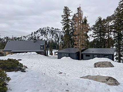
Cabins (center and right) and community building (left)
Frog Lake and the land surrounding it was purchased by the Truckee Donner Land Trust. They renovated the old buildings and built three rental cabins. These cabins are deluxe as is the community building. There is nothing else in the Sierra that compares to them.
There are two cabins that sleep 4 on platform beds, and one that sleeps 8. Each cabin has a table and seating area. There is also a bathroom with hot and cold running water, and the cabins are heated with propane so a light-weight sleeping bag is appropriate for a visit.
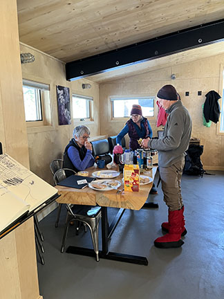
Community area in cabin
The community building is a restored stone building that now houses a lounge area and reading room, dining area, and an amazing commercial-like kitchen that includes all your cooking needs.

Lounge and dining area. Courtesy of Terri Michel.

Lounge area. Courtesy of Terri Michel.

Community kitchen

Cabins at Frog Lake
Mileage Log ![]()
Numbers in parentheses
correspond to mileage points on map
The first 3.5 miles follows groomed Nordic trails. In some areas there are multiple trails and it can be confusing. Be sure to get a trail map before starting and keep track of where you are. Keep in mind that your first goal is to reach the South Fork of Prosser Creek in Euer Valley. Then you want to follow Crabtree Road trail to the ski area boundary, which is at a high point on the road to the northwest of Peak 7096.
Waypoint 1 to 2
Miles: 0.0 - 0.3
Elevation change: +50 feet
From the trailhead (1) ski west and then north on the snow-covered road for a total of 0.3 mile, passing Pony Express trail, until you reach Northfork trail (2).
Waypoint 2 to 3
Miles: 0.3 - 0.8
Elevation change: +50 feet
Ski generally north on Northfork trail for 0.5 mile until you reach the Moondance warming hut (3) at the edge of a large, flat, open area.
Waypoint 3 to 4
Miles: 0.8 - 1.1
Elevation change: Nil
Follow Alder Creek Road for 0.3 mile until you reach a 180-degree turn in the road (4).
Waypoint 4 to 5
Miles: 1.1 - 1.7
Elevation change: -250 feet
Turn 180 degrees to the left (counter-clockwise) and continue on Alder Creek Road for 0.6 mile until you reach the bridge across the South Fork of Prosser Creek (5) in Euer Valley.
Waypoint 5 to 6
Miles: 1.7 - 3.5
Elevation change: +500 feet
Cross the bridge and continue on the groomed trail and then on Crabtree Road trail for a total of 1.8 miles until you reach the sign that indicates the boundary of the Nordic ski area (6). This point is at a high point on the road to the northwest of Peak 7096.
Waypoint 6 to 7
Miles: 3.5 - 4.1
Elevation change: -200 feet
Descend south on the road for 0.6 mile until you reach a road junction (7). This section of road is not shown on the USGS topo map but it exists. The route continues on the road to the southwest (straight) while the fork to the east (left) goes to a private ranch where visitors are not welcome.
Waypoint 7 to 8
Miles: 4.1 - 4.8
Elevation change: +300 feet
Ski southwest on the road, contouring the hillside, for 0.7 mile until the road turns northwest (8).
Waypoint 8 to 9
Miles: 4.8 - 5.4
Elevation change: +200 feet
Ski northwest on the road for 0.6 mile until the road makes a turn to the southwest (left) (9).
Waypoint 9 to 10
Miles: 5.4 - 6.3
Elevation change: +300 feet
Ski southwest on the road for 0.9 mile until you reach Frog Lake and Frog Lake Hut (10).
Frog Lake cabins. Courtesy of Terri Michel.
Return to trailhead
Miles: 6.3 - 12.6
Elevation change: +450, - 1400 feet
Retrace the route for 6.3 miles back to the trailhead (1).
