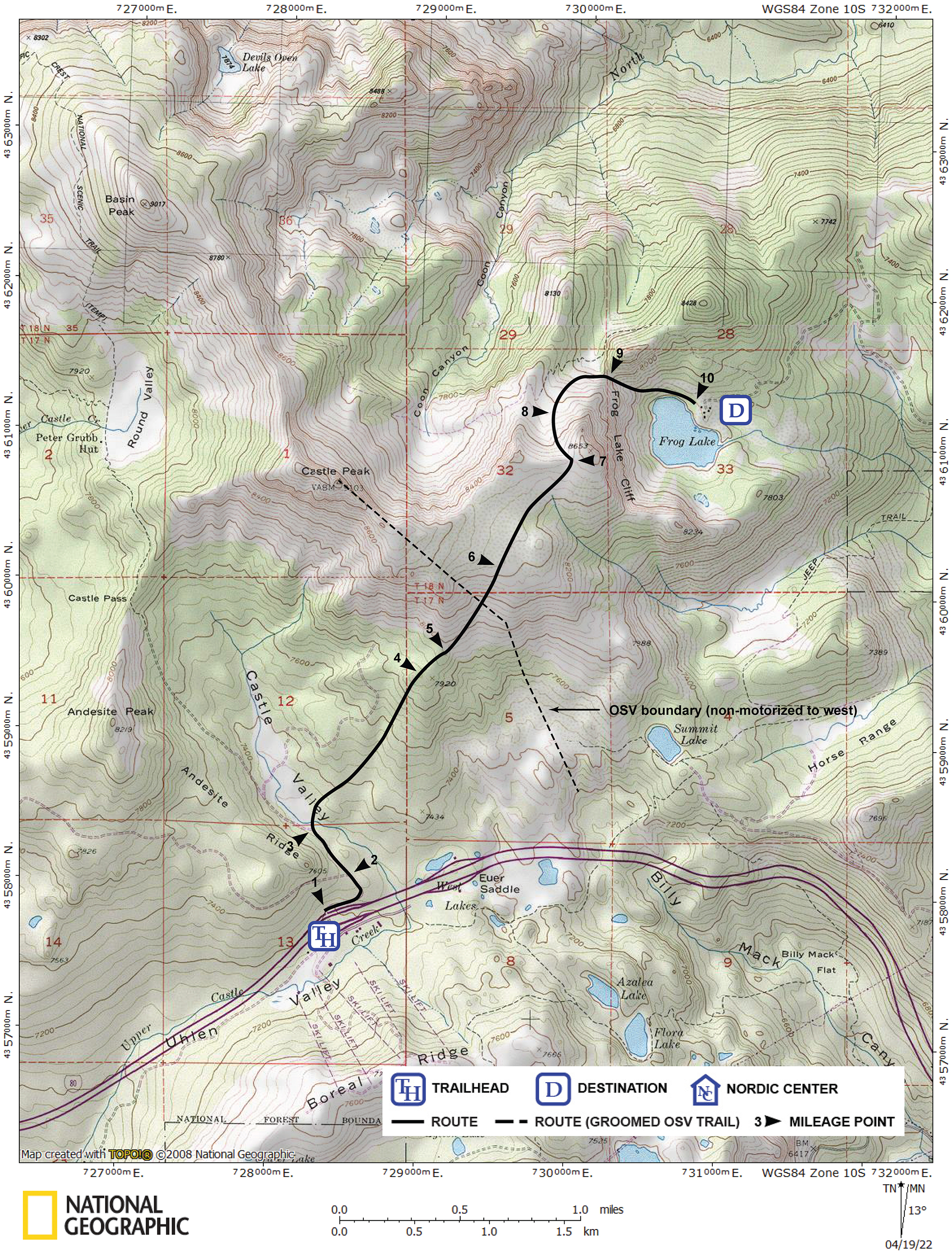
Summary ![]()
| Difficulty | 5 Advanced |
| Length | 7.4 miles round trip |
| Starting Elevation |
7200 feet |
| Cumulative Elevation Change |
+2300, -2300 round trip |
| Navigation | Road, map and compass |
| Time | Very long one day or two or more days with stay at Frog Lake Hut |
| Season | December through mid-April |
| Snowmobiles Use | Not permitted between mileage point 2 and boundary line shown on map. Low elsewhere. [Please report illegal use of snowmobiles in this area.] |
| USGS Topo | 7.5' series, Norden |
| Start | The plowed loading zone on the north side of Interstate 80 at the Castle Peak Area and Boreal Ridge exit. Parking is at the Donner Pass Sno-Park located at the east end of the frontage road on the south side of the interstate at the same exit. |
Description ![]()
Although not long in miles, this tour is very difficult and will take more time than the mileage suggests. By the map, the one-way distance to Frog Lake is 3.7 miles. The author clocked 5.1 miles due to the circuitousness of the actual route skied.
The route is also steep. After the initial easy section to the meadow in Castle Valley, in the next 2.0 miles you climb 1250 feet. Then it is a descent of 900 feet in 0.8 mile with one section where you descend 400 feet in 0.25 mile.
Along with the steep terrain, sections of the route are subject to avalanche. Check avalanche conditions and only ski this route if they are acceptable.
Although the tour is written up as a one-day tour, nearly all skiers will make it a multi-day tour with a couple of nights at the Frog Lake Hut. Why expend so much energy getting to the lake and hut, and not make time to enjoy it? Visit the Truckee Donner Land Trust website for details about Frog Lake Hut including how to make reservations.

Cabins (center and right) and community building (left)
Frog Lake and the land surrounding it was purchased by the Truckee Donner Land Trust. They renovated the old buildings and built three rental cabins. These cabins are deluxe as is the community building. There is nothing else in the Sierra that compares to them.
There are two cabins that sleep 4 on platform beds, and one that sleeps 8. Each cabin has a table and seating area. There is also a bathroom with hot and cold running water, and the cabins are heated with propane so a light-weight sleeping bag is appropriate for a visit.

Community area in cabin
The community building is a restored stone building that now houses a lounge area and reading room, dining area, and an amazing commercial-like kitchen that includes all your cooking needs.

Dining and lounge area. Courtesy of Terri Michel.

Lounge area. Courtesy of Terri Michel.

Community kitchen
This is only one of three route to Frog Lake described in this guide. The others are: Frog Lake From Johnson Canyon and Frog Lake From Tahoe Donner.
Mileage Log ![]()
Numbers in parentheses
correspond to mileage points on map
Waypoint 1 to 2
Miles: 0.0 - 0.3
Elevation change: +100 feet
From the trailhead (1) ski east on the snow-covered road that parallels the interstate and then northwest for a total of 0.3 mile until you reach a road junction (2). The tour continues northwest (straight) on the road while the road to the west (left) loops around the west side of Andesite Ridge.
Waypoint 2 to 3
Miles: 0.3 - 0.5
Elevation change: Nil
Ski northwest (straight) on the road for 0.2 mile until you see the meadow (3) in Castle Valley to the north. This is where you leave the road.
Waypoint 3 to 4
Miles: 0.5 - 1.5
Elevation change: +600 feet
Leave the road, enter the meadow, and ski north across the meadow for a total of 0.1 mile until you reach the trees. In this section you will cross Upper Castle Creek. Also, do not be tempted to ski northwest and up the meadow. Enter the trees and climb northeast for 0.9 mile until you reach a point just to the west of a small knob (4).
Waypoint 4 to 5
Miles: 1.5 - 1.7
Elevation change: +100, -50 feet
Ski northeast for 0.2 mile until you reach a small but prominent ridge (5).

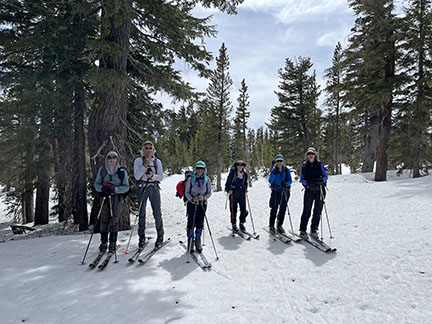
Many grand views along the route
Waypoint 5 to 6
Miles: 1.7 -2.1
Elevation change: +450 feet
Find a safe route off the ridge and then ski northeast for a total of 0.4 mile until you reach noticeably less steep terrain (6).

Traversing toward the steepest section above which the terrain is noticeably less steep. Photo taken during drought.
Waypoint 6 to 7
Miles: 2.1 - 2.7
Elevation change: +100 feet
Ski northeast over easy terrain for 0.6 mile until you reach a notch to the west of Frog Lake Cliff (7). In this section, initially you will be faced with finding a route through the small but dense trees.
Easier terrain before reaching ridgetop
Waypoint 7 to 8
Miles: 2.7 - 2.9
Elevation change: -300 feet
The hardest part of this section is getting off the top of the ridge. Find the best route for you, then loop northwest and north for a total of 0.2 mile until you reach the flattest part of the bowl (8).
Waypoint 8 to 9
Miles: 2.9 - 3.2
Elevation change: -200 feet
Continue north down the bowl and then loop east for a total of 0.3 mile until you reach a narrow gap (9) between the north ridge of Peak 8653 and an unnamed peak. The route finding in this section is critical and the route is not straight forward. Make sure that you do not descend past the gap into the canyon to the north.
Waypoint 9 to 10
Miles: 3.2 - 3.7
Elevation change: -400 feet
Descend east from the gap down what locals call "the ramp" for 0.5 mile until you reach Frog Lake and Frog Lake Hut (10). The route is narrow and the descent from the gap is the steepest section of the tour. If necessary, take off your skis and boot down. Frog Lake Hut is located adjacent to the lake on its northeast edge.

Frog Lake cabins. Courtesy of Terri Michel.
Return to trailhead
Miles: 3.7 to 7.4
Elevation change: +950, - 1350 feet
Retrace the route for 3.7 miles back to the trailhead (1).