
Summary ![]()
| Difficulty | 5 Advanced |
| Length | 9.0 miles round trip |
| Starting Elevation |
6400 feet |
| Cumulative Elevation Change |
+2250, -2250 round trip |
| Navigation | Road, map and compass |
| Time | Very long one day or two or more days with stay at Frog Lake Hut |
| Season | Late December through early April |
| Snowmobiles Use | Low |
| USGS Topo | 7.5' series, Norden |
| Start | Drive north from Interstate 80 at Donner Lake Road exit and almost immediately turn west (left) onto Billy Mac Road. In several hundred feet arrive at the Johnson Canyon Trailhead (sometimes called the Windin Way Trailhead). |
Description ![]()
The route to Frog Lake Hut from Johnson Canyon is not long, but it is difficult and will take more time than the mileage suggests. The first 1.5 miles is up a steep and narrow road. The return descent requires excellent control given the narrowness of the road..
The route then traverses with minor ups and downs for 2.1 miles. The last sections of the tour to Frog Lake includes a very steep 650-foot climb before a gentle run to the lake and hut.
Many sections of this tour pass through avalanche terrain. Check avalanche conditions and only ski this route if they are acceptable.
Although the tour is written as a one-day tour, nearly all skiers will make it a multi-day tour with a couple of nights at the Frog Lake Hut. Why expend so much energy getting to the lake and hut, and not make time to enjoy it? Visit the Truckee Donner Land Trust website for details about Frog Lake Hut including how to make reservations.
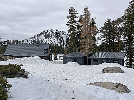
Cabins (center and right) and community building (left)
Frog Lake and the land surrounding it was purchased by the Truckee Donner Land Trust. They renovated the old buildings and built three rental cabins. These cabins are deluxe as is the community building. There is nothing else in the Sierra that compares to them.
There are two cabins that sleep 4 on platform beds, and one that sleeps 8. Each cabin has a table and seating area. There is also a bathroom with hot and cold running water, and the cabins are heated with propane so a light-weight sleeping bag is appropriate for a visit.

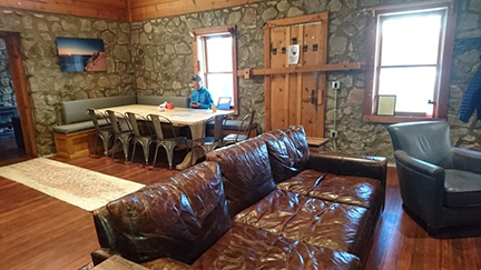
Community area in cabin
The community building is a restored stone building that now houses a lounge area and reading room, dining area, and an amazing commercial-like kitchen that includes all your cooking needs.
Lounge and dining area. Courtesy of Terri Michel.

Lounge area. Courtesy of Terri Michel.

Community kitchen
This is only one of three route to Frog Lake described in this guide. The others are: Frog Lake From Castle Valley and Frog Lake From Tahoe Donner.
Mileage Log ![]()
Numbers in parentheses
correspond to mileage points on map
Waypoint 1 to 2
Miles: 0.0 - 0.6
Elevation change: +350 feet
From the trailhead (1) ascend the steep road to the northwest for 0.6 mile until you reach a road junction (2).
Waypoint 2 to 3
Miles: 0.6 - 0.9
Elevation change: +200
Continue on the snow-covered road to the northwest (left) for 0.3 mile until you reach a 180-degree turn in the road (3).
Waypoint 3 to 4
Miles: 0.9 - 1.4
Elevation change: +200 feet
Continue on the snow-covered road as it loops southeast, then southwest and finally west for a total of 0.5 mile until you reach a ridgetop (4). In this section you will get your first view of Donner Lake below and will pass under powerlines.
At the ridgetop, be sure to take the short ski out to the southeast to Peak 7187. From the peak you will have views of Castle Peak to the northwest, Cisco Butte to the west, the railroad sheds on the south side of I-80 to the southwest, Anderson Peak to the south, Donner Lake to the southeast, and Northstar ski resort to the southeast.
Waypoint 4 to 5
Miles: 1.4 - 2.1
Elevation change: +200, -100 feet
Continue at first by ascending the road and ridge to the northwest and then continue by traversing northwest on the road for a total of 0.7 mile until you reach the end of the west ridge of Peak 7695 (5). Here you leave the security of the road behind.
Waypoint 5 to 6
Miles: 2.1 - 2.8
Elevation change: +100, -50 feet
Leave the road and ski north for 0.7 mile until you reach a low saddle to the west of Peak 7389 (6).
Waypoint 6 to 7
Miles: 2.8 - 3.5
Elevation change: +50, -350 feet
Ascend up the gentle slope toward Peak 7389 for 0.2 mile and then descend north for 0.5 mile to the South Fork of Prosser Creek (7).
Waypoint 7 to 8
Miles: 3.5 - 3.8
Elevation change: +200 feet
Ski north and then slightly east of north for a total of 0.3 mile until you reach a point to the east of Peak 7803 (8). There is no distinct landmark here so good navigation is necessary.
Waypoint 8 to 9
Miles: 3.8 - 4.5
Elevation change: +450 feet
Ascend the very steep slope to the northwest and then continue over more gradual terrain to the northwest for a total of 0.7 mile until you reach Frog Lake and Frog Lake Hut (9). The start of this section is the steepest part of the entire trip.

Frog Lake cabins. Courtesy of Terri Michel.
Return to trailhead
Miles: 4.5 - 9.0
Elevation change: +500, - 1750 feet
Retrace the route for 4.5 miles back to the trailhead (1).
