Summary ![]()
| Difficulty | 3 Intermediate |
| Length | 2.5 miles one-way or 3.6 miles round trip to Lake Angela |
| Starting Elevation |
7200 feet |
| Cumulative Elevation Change |
+150, -300 one-way or +250, -250 round trip to Lake Angela |
| Navigation | Map and compass |
| Time | Several hours one-way or half day round trip |
| Season | Late December through mid-April |
| Snowmobiles Use | Low |
| USGS Topo | 7.5' series, Norden |
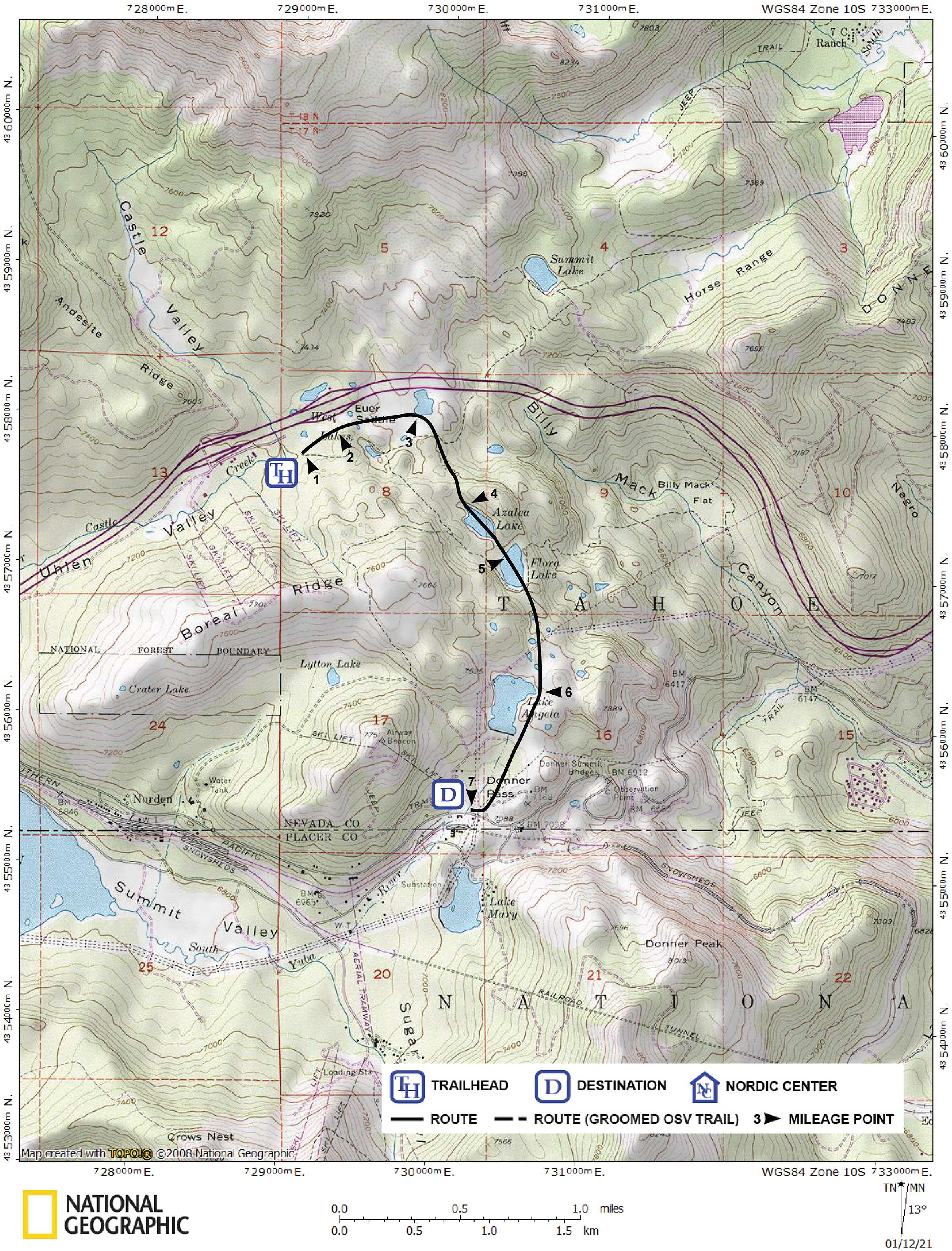
| Start | Near the restroom at the east end of the Donner Pass Sno-Park on Interstate 80. Exit the interstate at Castle Peak Area and Boreal Ridge. Drive east on the south frontage road for 0.2 mile to the Sno-Park. |
| End | One-way tour ends at Donner Ski Ranch, 3.7 miles east of Interstate 80 on Donner Pass Road. |
Description ![]()
Along the Lakes Crossing tour you will pass by Azalea Lake, Flora Lake and Lake Angela. The first two lakes are situated in a beautiful area rich in granite walls and steep slopes. A small rise to the east of Flora Lake affords a wonderful view of Donner Lake, the interstate and the transcontinental railroad — a great place for lunch if the sounds of the cars and trucks on the interstate do not bother you. If they do, eat at one of the lakes.

Skiing from Azalea Lake to Flora Lake
The greater Lake Angela area is barren and the beauty of its starkness is marred only by the power lines that pass nearby. You also have views south of Donner Peak, the ridge of which Mount Judah is a part, Mount Lincoln, and much more.
This tour, from Interstate 80 to Donner Pass Road, rolls across relatively level terrain filled with numerous short ups and downs. Although technically not difficult, navigating efficiently can be a little troublesome due to the many little features that break up straight-forward progress in the first mile of the tour. The mileage log will help you through the first mile, but a couple of compass bearings is the ideal solution — use this as an opportunity to practice your compass skills.

A sample of the features that must be negotiated on the way to Azalea Lake
This tour can also be skied as a round trip tour by making one of the lakes your destination and then retracing the route back to the starting point. Another alternative is to visit the lakes in this tour via the easier Lake Angela, Flora Lake and Azalea Lake tour if you have any doubts in your ability to navigate the described route. A third alternative, the Lakes Crossing Loop tour, describes a route suitable to intermediate-advanced skiers that returns to the start at the Sno-Park via an outstanding route that crosses Boreal Ridge.
Exercise caution before skiing across the lakes described in this tour.
Mileage Log ![]()
Numbers in parentheses
correspond to mileage points on map
Waypoint 1 to 2
Miles: 0.0 - 0.2
Elevation change: +50 feet
From the trailhead (1) ski northeast for 0.2 mile until you are adjacent to the rest area (2) on the south side of the interstate.
Waypoint 2 to 3
Miles: 0.2 - 0.5
Elevation change: -50 feet
Ski east and parallel to the interstate for 0.3 mile until you reach an open area (3).
Waypoint 3 to 4
Miles: 0.5 - 1.0
Elevation change: +50, -50 feet
Ski southeast for 0.5 mile until you reach Azalea Lake (4).

Interesting terrain leading to a short descent to Azalea Lake
Waypoint 4 to 5
Miles: 1.0 - 1.3
Elevation change: Nil
Ski southeast for 0.3 mile until you reach Flora Lake (5). Don't forget to visit the top of the rise to the east!

Crossing Flora Lake to low rise overlooking Donner Lake
Waypoint 5 to 6
Miles: 1.3 - 1.8
Elevation change: +50 feet
Ski south, picking the best route around little obstacles, for 0.5 mile until you reach Lake Angela (6).
Continuing to Donner Pass Road
Waypoint 6 to 7
Miles: 1.8 - 2.5
Elevation change: -200 feet
Ski southwest along Lake Angela to the dam, then gradually descend southwest and finally ski west for a total of 0.7 mile until you reach Donner Ski Ranch (7) on Donner Pass Road.
Returning to the Sno-Park from Lake Angela
Return to trailhead
Miles: 1.8 - 3.6
Elevation change: +100, -150 feet
Retrace the route for 1.8 miles back to the trailhead (1).