Summary ![]()
| Difficulty | 4 Intermediate-advanced |
| Length | 3.2 miles round trip |
| Starting Elevation |
7200 feet |
| Cumulative Elevation Change |
+550, -550 round trip |
| Navigation | Map and compass |
| Time | Half day |
| Season | Late December through mid-April |
| Snowmobiles Use | Low |
| USGS Topo | 7.5' series, Norden |
| Start | Near the restroom at the east end of the Donner Pass Sno-Park on Interstate 80. Exit the interstate at Castle Peak Area and Boreal Ridge. Drive east on the south frontage road for 0.2 mile to the Sno-Park. |
Description ![]()
The Lake Crossing Loop tour combines the almost level terrain of the Lakes Crossing tour with a climb to the top of Boreal Ridge before descending back to the starting point at the Donner Pass Sno-Park. Plan your trip right and you can revel in the powder that is often found on the north-facing side of the ridge that you descend.
Along this tour you will pass by Azalea Lake, Flora Lake and Lake Angela. The first two lakes are situated in a beautiful area rich in granite walls and steep slopes. A small rise to the east of Flora Lake affords a wonderful view of Donner Lake, the interstate and the transcontinental railroad — a great place for lunch if the sounds of the cars and trucks on the interstate do not bother you. If they do, eat at one of the lakes.

You may be lucky enough to find a granite wall encrusted with icicles
Not far beyond Flora Lake the navigation becomes easier and the terrain drastically changes. The greater Lake Angela area is barren and the beauty of its starkness is marred only by the power lines that pass nearby. You also have views south of Donner Peak, the ridge of which Mount Judah is a part, Mount Lincoln, and much more.
Exercise caution before skiing across the lakes described in this tour.
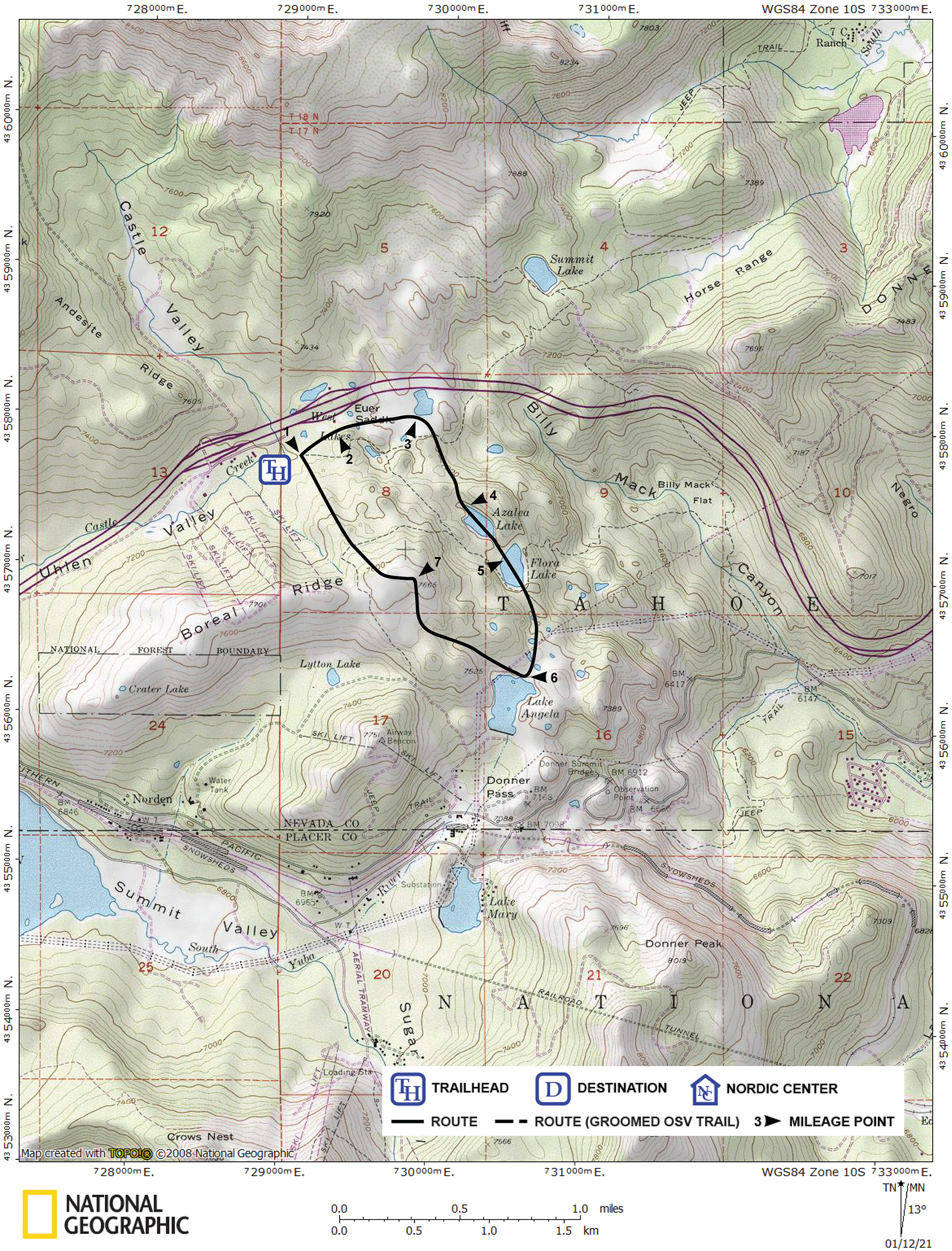
Mileage Log ![]()
Numbers in parentheses
correspond to mileage points on map
Waypoint 1 to 2
Miles: 0.0 - 0.2
Elevation change: +50 feet
From the trailhead (1) ski northeast for 0.2 mile until you are adjacent to the rest area (2) on the south side of the interstate.
Waypoint 2 to 3
Miles: 0.2 - 0.5
Elevation change: -50 feet
Ski east and parallel to the interstate for 0.3 mile until you reach an open area (3).
Waypoint 3 to 4
Miles: 0.5 - 1.0
Elevation change: +50, -50 feet
Ski southeast for 0.5 mile until you reach Azalea Lake (4).
Waypoint 4 to 5
Miles: 1.0 - 1.3
Elevation change: Nil
Ski southeast for 0.3 mile until you reach Flora Lake (5). Don't forget to visit the top of the rise to the east!
Waypoint 5 to 6
Miles: 1.3 - 1.8
Elevation change: Nil
Ski south, picking the best route around little obstacles, for 0.5 mile until you reach Lake Angela (6).
Waypoint 6 to 7
Miles: 1.8 - 2.5
Elevation change: +450 feet
Climb northwest for 0.7 mile until you reach Peak 7665 (7).
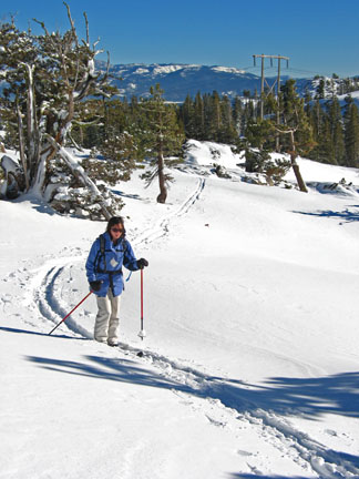
Winding the way from Lake Angela to Peak 7665 on Boreal Ridge
Waypoint 7 to 1
Miles: 2.5 - 3.2
Elevation change: -450 feet
Descend northwest for 0.7 mile until you reach the trailhead (1). Be aware that the descent is made difficult by dense woods in places. Move right or left as you descend in order to find the best route; when in doubt, move right because far to the left the tree spacing is very tight.

On the edge before dropping down to the northwest with Castle Peak in the background