
Summary ![]()
| Difficulty | 3 Intermediate |
| Length | 5.5 miles one-way to Burst Rock Junction or 11.0 miles round trip |
| Starting Elevation |
6400 feet |
| Cumulative Elevation Change |
+1950, -200 feet one-way to Burst Rock Junction or +2150, -2150 feet round trip |
| Navigation | Road, marked trail and map |
| Time | Full day |
| Season | December through mid-April |
| Snowmobiles Use | Not permitted [Please report illegal use of snowmobiles in this area.] |
| USGS Topo | 7.5' series, Pinecrest |
| Start | Dodge Ridge Ski Resort parking loop. Follow Dodge Ridge Road to where the one-way loop of the ski area parking lot begins. A right turn at this point leads into the parking area at the Crabtree Trailhead. |
Description ![]()
The Old Crabtree Road tour all the way to Burst Rock Junction is an extension of The Knob tour. Many people will choose to turn around at The Knob or complete one of the loop tours of which The Knob is the farthest point. Continuing to Burst Rock Junction can be viewed as an easy extension given there is little elevation change or as a means of creating a grand loop tour by connecting with either the Gooseberry Road tour or the Crabtree Road tour.
However you choose to return, any tour to Burst Rock Junction is a long one.
Mileage Log ![]()
Numbers in parentheses
correspond to mileage points on map
Note: The Pinecrest Nordic Ski Patrol has marked many backcountry ski trails in this area. Where applicable, the numbers and name of the trails are given in brackets. Visit their website to download a map showing all the marked trails or obtain a map at the Summit Ranger District office at #1 Pinecrest Lake Road near the junction with Highway 108.
Waypoint 1 to 3
Miles: 0.0 - 0.4
Elevation change: -50 feet
From the trailhead (1) ski on the spur road that weaves southwest for 0.4 mile until you reach the intersection with Crabtree Road (3). You may or may not see the road junction at mileage point 2, which is located 0.1 mile from Crabtree Road. The road that intersects the spur road you are on enters from the east (left), is part of a series of roads that lead to the ski resort, and is sometimes groomed. You will know you are at Crabtree Road because a stop sign and road direction sign will probably be visible.
Waypoint 3 to 5
Miles: 0.4 - 1.6
Elevation change: +550 feet
Turn southeast (left) onto Crabtree Road and ski in that direction for 0.9 mile and then north for 0.3 mile until you reach Hair Pin (5) an almost 180-degree turn in the road. You may or may not see the road junction at mileage point 4, which is located 0.4 mile from the previous road junction. The junction at mileage point 4 is a Y with the north-most (left) fork heading downhill and is part of a series of roads that lead to the ski resort. It is sometimes groomed. This tour stays on the larger, south-most (right) fork. [#5 Aspen Meadow trail]
 Crabtree Road
Waypoint 5 to 6
Miles: 1.6 - 2.1
Elevation change: +150 feet
Continue climbing south on Crabtree Road for 0.5 mile until you reach a road junction (6). The road makes a left turn just before you reach the junction. [#5 Aspen Meadow trail]
You can make an interesting short detour from the road junction by skiing west, at first through trees and then in the open, for 0.1 mile until you reach the top of a ridge from which there is an expansive view to the north and west.
Waypoint 6 to 7
Miles: 2.1 - 2.2
Elevation change: Nil
Continue east (straight) on Crabtree Road for 0.1 mile until you reach a pack station and Aspen Meadow (7). [#5 Aspen Meadow trail]
 Aspen Meadow
Waypoint 7 to 8
Miles: 2.2 - 3.0
Elevation change: +250 feet
Continue skiing slightly north of east on Crabtree Road for 0.8 mile until you reach a road junction (8). Crabtree Road continues to the southwest (right). This tour continues slightly north of east (straight) on Old Crabtree Road. [#5 Aspen Meadow trail]
Waypoint 8 to 9
Miles: 3.0 - 3.8
Elevation change: +400 feet
Continue skiing slightly north of east (straight) on Old Crabtree Road for 0.5 mile and then south on the road for 0.3 mile until you reach a ridge (9). [#11 Nordic Run trail]
Waypoint 9 to 10
Miles: 3.8 - 4.7
Elevation change: +450 feet
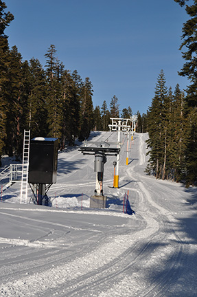
Ascend northeast and then north along Old Crabtree Road and the ridge for a total of 0.9 mile until you reach The Knob (10). You can't miss the summit with the top of two chairlifts located there. [#11 Nordic Run trail]
 View east on approach to The Knob
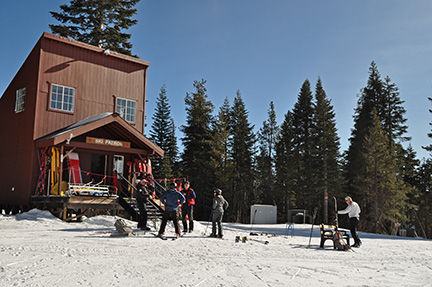 Ski patrol building at The Knob
Waypoint 10 to 11
Miles: 4.7 - 4.9
Elevation change: -100 feet
Descend to the northeast on Old Crabtree Road, which will be groomed, for 0.2 mile until you reach a saddle and the bottom of a tee-bar lift (11). Here you have two choices: (a) You can continue northeast on the groomed slope of the tee-bar run or (b) you can locate the marked trail located to the south of the groomed tee-bar run and follow it to the northeast. [#8 Knob trail]
 Bottom of tee-bar lift
Waypoint 11 to 12
Miles: 4.9 - 5.1
Elevation change: +100 feet
Continue northeast either along the edge of the groomed slope or on the marked trail in the trees to the south of the groomed slope for 0.2 mile until you reach the hut at the end of the tee-bar lift (12) or are adjacent to it if you are on the marked trail. [#8 Knob]
Waypoint 12 to 13
Miles: 5.1 - 5.5
Elevation change: +50, -50 feet
Locate the marked trail in the trees to the south of the hut if you are not already on it and continue northeast on snow-covered Old Crabtree Road for 0.4 mile until you reach Burst Rock Junction (13). The junction is well marked with multiple signs on a large tree. [#8 Knob]
Return to trailhead
Miles: 5.5 - 11.0
Elevation change: +200, -1950 feet
Retrace the route for 5.5 miles back to the trailhead (1) or return to Dodge Ridge ski area by the Gooseberry Road tour or Crabtree Road tour.
