Summary ![]()
| Difficulty | 3 Intermediate |
| Length | 2.9 miles round trip |
| Starting Elevation |
8600 feet |
| Cumulative Elevation Change |
+450, -500 feet |
| Navigation | Road, marked trail and map |
| Time | Half day |
| Season | Early December through mid-April |
| Snowmobiles Use | Not permitted [Please report illegal use of snowmobiles in this area.] |
| USGS Topo | 7.5' series, Carson Pass and Caples Lake |
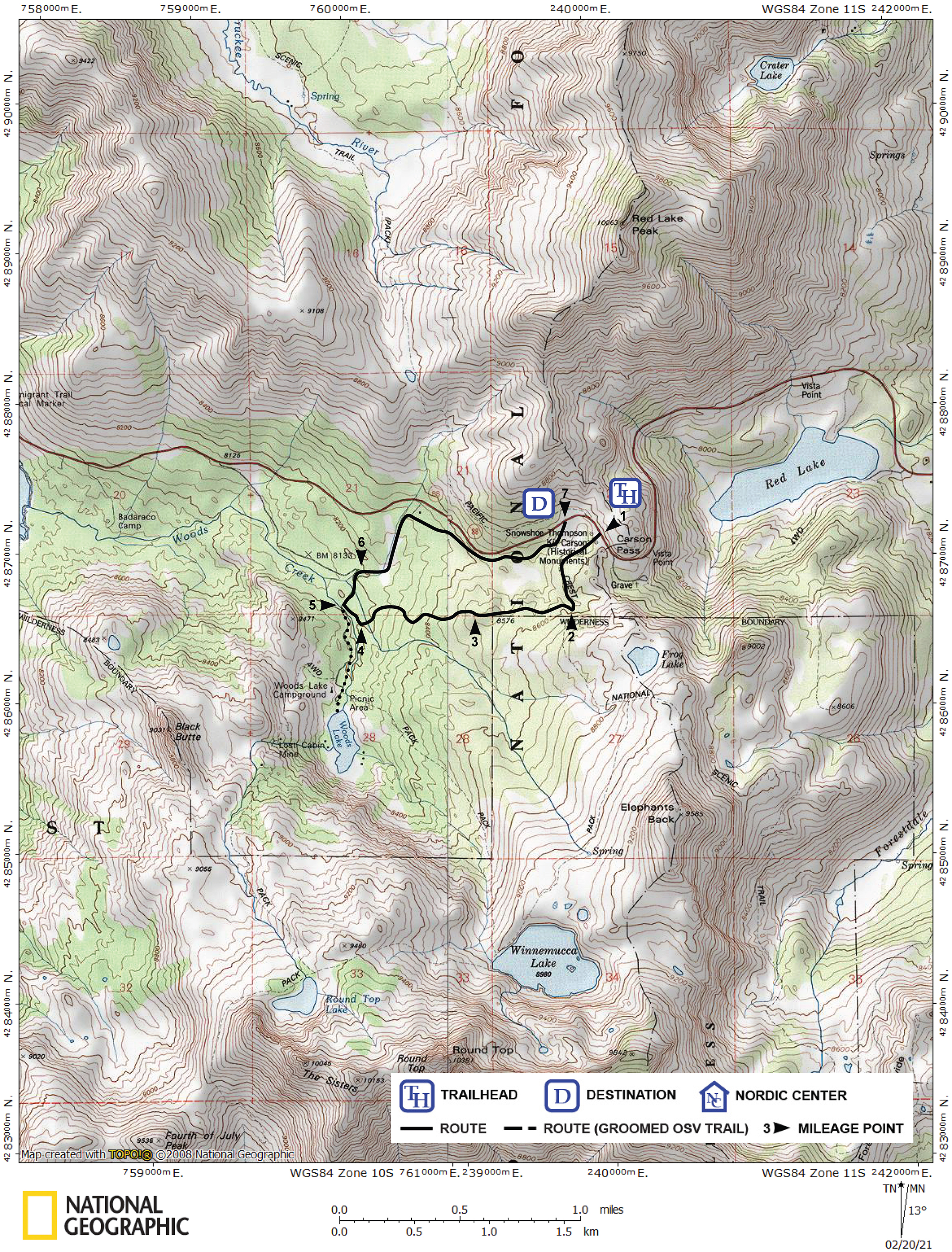
| Start | Carson Pass Sno-Park on Highway 88. |
| End | Meiss Sno-Park, 0.1 mile west of Carson Pass on Highway 88. |
Description ![]()
The Wilderness Boundary Loop combines the very popular tour to Woods Lake, which follows snow-covered roads, with the Wilderness Boundary trail, which gets relatively little use and parallels the Mokelumne Wilderness boundary for part of its length.
In one six-tenths-mile section, the Wilderness Boundary trail descends 350 feet through dense woods on its way from Carson Pass to its intersection with the road to Woods Lake. Many skiers will find this steep and made more difficult by the trees that must be negotiated. You can avoid descending this section by skiing the loop in a counterclockwise direction as opposed to the clockwise direction described. Irregardless of the direction skied, you will need to carefully follow the blue diamond markers through the trees because there is no landform to follow. Fortunately, lots of trail markers were added in the fall of 2009 by volunteers of Snowlands Network and the El Dorado Nordic Ski Patrol.
Mileage Log ![]()
Numbers in parentheses
correspond to mileage points on map
Waypoint 1 to 2
Miles: 0.0 - 0.4
Elevation change: +50, -50 feet
From the trailhead (1) follow the marked trail southwest and then south for a total of 0.4 mile until you reach the location near the Mokelumne Wilderness boundary where the marked trail turns west (2). There is no landmark at this location, but you will notice an abrupt change in direction and a compass will show that you are now headed almost perfectly (true) west.
Going forward, if you loose the market trail, just head west; that will cause you to intersect the creek that drains Winnemucca Lake and the Woods Lake road is nearby.
Waypoint 2 to 3
Miles: 0.4 - 0.8
Elevation change: +50, -100 feet
Follow the marked trail west for a total of 0.4 mile until you reach the location where the trail abruptly begins to descend (3).
Waypoint 3 to 4
Miles: 0.8 - 1.4
Elevation change: -350 feet
Descend to the west on the twisting marked trail for 0.6 mile until you reach a junction of marked trails (4). The marked trail to the south leads up the Winnemucca Lake drainage. The marked trail to the northwest leads to the Woods Lake road.
Waypoint 4 to 5
Miles: 1.4 - 1.5
Elevation change: Nil
Follow the marked trail northwest for 0.1 mile until you reach the Woods Lake road (5). You should intersect the road at a bridge across a small creek. Woods Lake is 0.4 mile to the south (left) on the road and well worth the short excursion.
Waypoint 5 to 6
Miles: 1.5 - 1.7
Elevation change: Nil
Turn north (right) onto the Woods Lake road and follow it for 0.2 mile until you reach a road junction (6). This junction may not be obvious, but the marked road abruptly turns east (right) here.
Waypoint 6 to 7
Miles: 1.7 - 2.9
Elevation change: +350 feet
Turn east (right) and ascend along the road for 1.2 miles until you reach Highway 88 (7). At this point you are across the highway from the Meiss Sno-Park and 0.1 west of the Carson Pass Sno-Park. Carefully walk along the highway to your vehicle at Carson Pass.