Summary ![]()
| Difficulty | 2 Beginner-intermediate |
| Length | 3.6 miles round trip to lake and 4.8 miles round trip with addition of extension to Lost Cabin Mine |
| Starting Elevation |
8600 feet |
| Cumulative Elevation Change |
+450, -450 feet |
| Navigation | Road and marked trail |
| Time | Half day |
| Season | Late November through April |
| Snowmobiles Use | Not permitted [Please report illegal use of snowmobiles in this area.] |
| USGS Topo | 7.5' series, Carson Pass and Caples Lake |
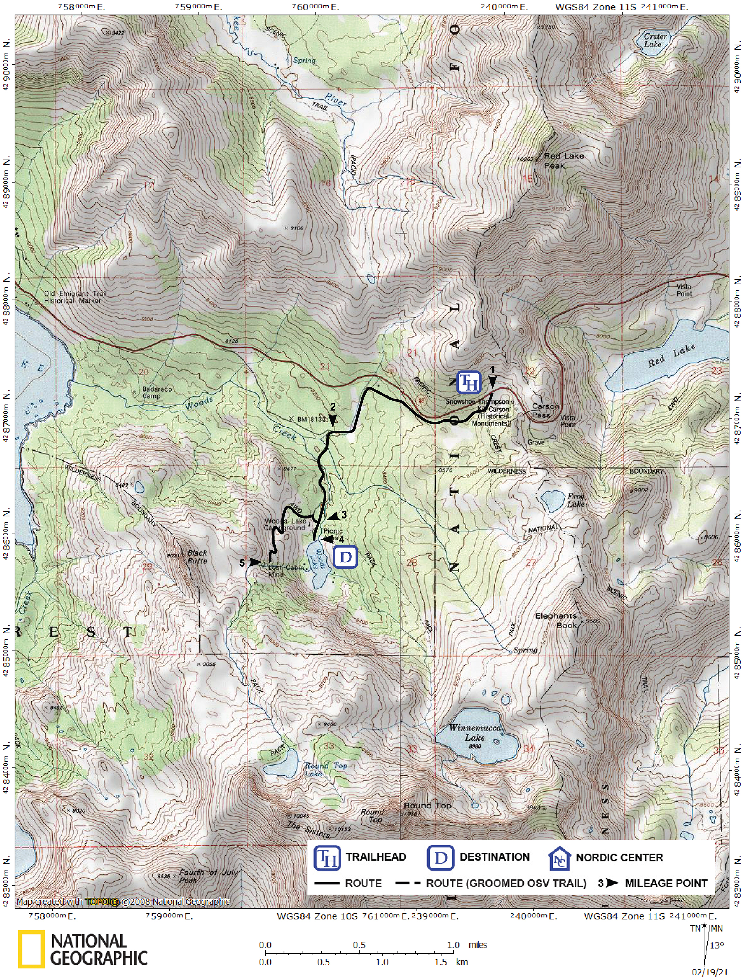
| Start | Meiss Sno-Park, 0.1 mile west of Carson Pass on Highway 88. |
Description ![]()
The Woods Lake tour is an anomaly in the Carson Pass area and its differences make it a popular destination. In contrast, to the intermediate and more difficult destinations in the area, this tour is suitable for advanced beginner skiers. Instead of passing through high, open rolling terrain and steep bowls, the route to the lake follows a snow-covered road through dense woods, which offers protection in stormy weather. With only a little experience you will be able to complete this pleasant tour.
The Woods Lake tour is an excellent choice early and late in the season when lower elevations have insufficient or marginal snow-cover. The lake is also a wonderful place to relax and enjoy lunch.
One word of caution is appropriate here. After warm weather the snow will freeze each night and the tree-shaded route will not thaw until mid-afternoon if it is warm or not at all if it turns cold. Icy conditions down the gradually descending road from the pass can be difficult for newbie skiers. So plan your trip here accordingly.
You can also extend the Woods Lake tour by adding a 1.2-mile round trip extension to Lost Cabin Mine. This addition will require you to locate a less well defined road, which you climb to reach the mine. This narrow road will force you to control your speed on the descent or you may find yourself crashing and burning if you are only a beginner-intermediate skier.
Mileage Log ![]()
Numbers in parentheses
correspond to mileage points on map
Waypoint 1 to 2
Miles: 0.0 - 1.2
Elevation change: -350 feet
Cross to the south side of Highway 88 at the entrance to the Meiss Sno-Park (1), locate the snow-covered road that enters the trees just to the west (right) of the meadow and descend the road for 1.2 miles until you reach a road junction (2). This junction may not be obvious, but the marked route turns south (left) here towards Woods Lake. You will find yourself climbing very gradually northwest back to the highway if you miss the turn at the junction.
Waypoint 2 to 4
Miles: 1.2 - 1.8
Elevation change: +50 feet
Continue south on the road for 0.6 mile until you reach Woods Lake (4).
Return to trailhead
Miles: 1.8 - 3.6
Elevation change: +350, -50 feet
Retrace the route for 1.8 miles back to the trailhead (1). You can extend the tour by following the route described below to Lost Cabin Mine.
Route to Lost Cabin Mine
The route to Lost Cabin Mine begins 0.1 mile north of Woods Lake. Locate the point on the road, which you skied to the lake, where there is an open route on the west side of the road (3).
Waypoint 3 to 5
Miles: 0.0 - 0.6
Elevation change: +250 feet
Ski west and then south for a total of 0.6 mile, following a road that may not be obvious in places, until you reach Lost Cabin Mine (5). The last part of this section is more steep and along a narrow road with sharp turns.
Waypoint 5 to 3
Miles: 0.6 - 1.2
Elevation change: -250 feet
Retrace the route for 0.6 mile back to the main road (3) to return to the Woods Lake tour.