Summary ![]()
| Difficulty | 3 Intermediate |
| Length | 4.9 miles round trip |
| Starting Elevation |
8600 feet |
| Cumulative Elevation Change |
+900, -1000 feet |
| Navigation | Road, marked trail and map |
| Time | Most of a day |
| Season | Late December through April |
| Snowmobiles Use | Not permitted [Please report illegal use of snowmobiles in this area.] |
| USGS Topo | 7.5' series, Carson Pass and Caples Lake |
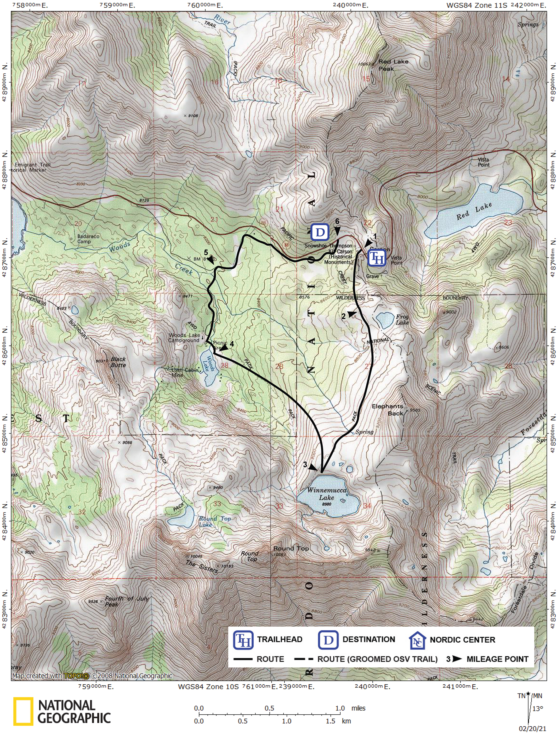
| Start | Carson Pass Sno-Park on Highway 88. |
| End | Meiss Sno-Park, 0.1 mile west of Carson Pass on Highway 88. |
Description ![]()
This loop is only slightly longer than the Winnemucca Lake tour, but allows you to explore much more territory without retracing your tracks. Sometimes, more likely in the spring, the descent to Woods Lake can be delightful.
Woods Lake is a popular destination in its own right and is most easily reached via the Woods Lake tour on roads.
Mileage Log ![]()
Numbers in parentheses
correspond to mileage points on map
Waypoint 1 to 2
Miles: 0.0 - 0.5
Elevation change: +300, -50 feet
From Carson Pass Sno-Park (1) ski south into the trees and climb for approximately 0.5 mile until you reach more open and level terrain (2). Don't get discouraged — the first little bit is the most difficult.
Waypoint 2 to 3
Miles: 0.5 - 1.8
Elevation change: +250, -100 feet
Continue skiing south and traverse the open slopes on the west side of Elephant Back for 1.3 miles until you reach Winnemucca Lake (3), which lies in a depression below Round Top.
Waypoint 3 to 4
Miles: 1.8 - 3.0
Elevation change: -800 feet
Ski north and then gradually curve northwest on the east (right) side of the Winnemucca Lake outlet creek for 1.2 miles until you reach Woods Lake (4).
Waypoint 4 to 5
Miles: 3.0 - 3.7
Elevation change: -50 feet
Locate the road at the north end of Woods Lake and follow it north for a total of 0.7 mile until you reach a road junction (5). This junction may not be obvious.
Waypoint 5 to 6
Miles: 3.7 - 4.9
Elevation change: +350 feet
Turn east (right) and ascend along the road for 1.2 miles until you reach Highway 88 (6). At this point you are across the highway from the Meiss Sno-Park and 0.1 west of the Carson Pass Sno-Park. Carefully walk along the highway to your vehicle at Carson Pass.