
Summary ![]()
| Difficulty | 5 Advanced |
| Length | 9.7 miles one-way |
| Starting Elevation |
7350 feet |
| Cumulative Elevation Change |
+1800, -2450 feet |
| Navigation | Road and map |
| Time | Full day |
| Season | Mid-December through mid-April (it may not be safe to ski on the lakes early and late in the season) |
| Snowmobiles Use | Not permitted in the Echo Lakes basin. Low beyond Echo Peak. [Please report illegal use of snowmobiles in this area] |
| USGS Topo | 7.5' series, Echo Lake, Emerald Bay |
| Start | Echo Lake Sno-Park. From 1.2 miles west of the Echo Summit Maintenance Station on Highway 50, drive 0.6 mile east on Johnson Pass Road toward Berkeley Camp to the Sno-Park. The actual trailhead is the snow-covered road opposite the entrance to the Sno-Park. |
| End | From the intersection of Highways 50 and 89 in South Lake Tahoe, drive southwest on Lake Tahoe Blvd. for 2.7 miles and turn right onto Tahoe Mountain Road. Drive 1.1 miles and turn right onto Glenmore Way and then immediately left onto Dundee Circle. In 0.1 mile turn left onto Tahoe Mountain Road once again and park. Do not drive down the narrow plowed portion of Tahoe Mountain Road which is just ahead. A sign at the parking area says: “No parking on public road right-of-way when snow removal conditions exist.” |
Description ![]()
From miles of flats to the steeps, crossing Echo Peak from Echo Lakes to Angora Lakes is the quintessential contrast of terrain. You should pick this tour because you relish the challenge of the very steep descent from the summit of Echo Peak combined with a relatively long tour.
First you ski two miles across Echo Lakes cradled between Becker Peak, Talking Mountain, Flagpole Peak and Echo Peak. This section in itself is filled contrast; the lake is flat and stark yet surrounded by steep ridges.
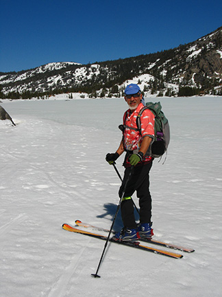
Skiing along south shore of Lower Echo Lake
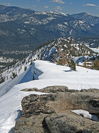
Then you climb to the summit of Echo Peak. Here you are treated to an amazing 360-degree panorama. Below to the north are Angora Lakes nestled up among the steep cliffs of Echo Peak. Farther to the north is the deep blue of Fallen Leaf Lake and Lake Tahoe. To the south are Echo Lakes and views beyond.

Echo Peak
Next comes the descent from Echo Peak to Angora Lakes. It's steep; more than 1300-feet in one mile.

Snow-covered Angora Lakes, Fallen Leaf Lake (left) and Lake Tahoe
The tour ends with more than three miles of level and moderate downhill terrain.
Picking the right time to ski this tour requires guessing what the snow conditions will be on the north side of Echo Peak. On the south side the snow consolidates and turns to corn quickly due to the south-facing slope. On the north side powder lingers because the sun does not hit these slopes, but this translates to very slow consolidation. In fact, don't visit looking for spring corn; plan a trip for powder conditions for the best skiing.
Please stay away from the many privately owned cabins at Echo Lakes. Also, be aware that overnight camping is not permitted in the lakes basin.
Mileage Log ![]()
Numbers in parentheses
correspond to mileage points on map
Waypoint 1 to 2
Miles: 0.0 - 1.2
Elevation change: +150, -100 feet
Locate the snow-covered road and trailhead (1) opposite the entrance to the Sno-Park and follow the road northwest for 1.2 miles until you reach the southeast end of Lower Echo Lake (2). You can expect a gradual climb followed by a short, steep descent to the lake. Stay left on the obvious main road if you see any road junctions.
Waypoint 2 to 3
Miles: 1.2 - 2.6
Elevation change: Nil
If it is safe, ski northwest across the lower lake for 1.4 miles until your each its northwest end (3). Otherwise ski along the south edge of Echo Lakes. Skiing along the summer trail on the north side of the lakes is slow, more difficult, and no substitute for the open, hard-packed surface of the lakes.
Waypoint 3 to 4
Miles: 2.6 - 2.7
Elevation change: Nil
Ski west for 0.1 mile until you reach the southeast end of Upper Echo Lake (4).
Waypoint 4 to 5
Miles: 2.7 - 3.3
Elevation change: Nil
Ski northwest across the upper lake for 0.6 mile until you reach its northwest end (5).
Waypoint 5 to 6
Miles: 3.3 - 3.7
Elevation change: +150 feet
Ski west for 0.4 mile until the terrain to the north becomes less steep (6) (there is no landmark).
Waypoint 6 to 7
Miles: 3.7 - 5.1
Elevation change: +1300 feet
Ski in an arc, first north and ending east, for 1.4 miles until you reach the summit of Echo Peak (7).
Waypoint 7 to 8
Miles: 5.1 - 5.2
Elevation change: -100 feet
Ski east along the ridge for 0.1 mile until you reach a point where you can safely leave the ridge to the north (8) and reach the broad ridge that heads northeast.
Looking east from Echo Peak toward descent route to north (left)
Waypoint 8 to 9
Miles: 5.2 - 6.1
Elevation change: -1350 feet
Descend onto the broad ridge and follow it northeast and finally north for a total of 0.9 mile until you reach Angora Lakes (9). The ridge is usually the safest place near the top; as you descend you can move into the shallow gully to the west of the ridge where mature trees provide some protection from avalanches. Be sure to assess the avalanche conditions before attempting the descent.

Echo Peak from Angora Lakes (descent is along ridge and shallow gully on left)
Waypoint 9 to 10
Miles: 6.1 - 7.1
Elevation change: +50, -250 feet
Locate the road and follow it generally a bit east of north for 1.0 mile until you reach a ridgetop (10).
Waypoint 10 to 11
Miles: 7.1 - 7.8
Elevation change: +100, -50 feet
Ski northeast on the ridge and road for 0.7 mile until you reach Angora Lookout (11).
Waypoint 11 to 12
Miles: 7.8 - 9.6
Elevation change: -600 feet
Continue northeast on the road for 1.8 miles until you reach Tahoe Mountain Road (12). The first 1.2 miles descends steadily and the last 0.6 mile is level. You will pass to the west (left) of a small meadow as you approach Tahoe Mountain Road.
Waypoint 12 to 13
Miles: 9.6 - 9.7
Elevation change: +50 feet
Turn east (right) onto Tahoe Mountain Road and follow it for 0.1 mile to the end of the tour (13). You will need to walk this section if it is plowed.

