Summary ![]()
| Difficulty | 4 Intermediate-advanced |
| Length | 10.2 miles round trip |
| Starting Elevation |
7350 feet |
| Cumulative Elevation Change |
+1700, -1700 feet |
| Navigation | Road and map |
| Time | Full day |
| Season | Mid-December through mid-April (it may not be safe to ski on the lakes early and late in the season) |
| Snowmobiles Use | Not permitted [Please report illegal use of snowmobiles in this area] |
| USGS Topo | 7.5' series, Echo Lake |
| Start | Echo Lake Sno-Park. From 1.2 miles west of the Echo Summit Maintenance Station on Highway 50, drive 0.6 mile east on Johnson Pass Road toward Berkeley Camp to the Sno-Park. The actual trailhead is the snow-covered road opposite the entrance to the Sno-Park. |
Description ![]()
The climb to the rocky summit of Echo Peak is a 100 percent perfect tour for both experienced skiers and skiers desiring to tackle their first ski ascent. Easy access, although more than three miles to the start of the climb, and the easy route-finding will give newcomers to peak bagging on skis a sense of security. Skiers skilled in the art of telemarking can enjoy 1300 feet of linked turns on the descent.

Echo Peak
The climbing, through a mixture of open and wooded areas, is steady and the gradient only modestly steep for a peak climb. The view from the summit is a 360-degree panorama — an ideal setting for a well deserved lunch. Directly below the steep cliffs to the north are Angora Lakes and almost at your finger tips are Fallen Leaf Lake and Lake Tahoe. Of course, you will have more than sufficient opportunity to enjoy the Echo Lakes basin and the views to the south.

Snow-covered Angora Lakes, Fallen Leaf Lake (left) and Lake Tahoe
One word of advice for planning a trip to Echo Peak: Because the entire ascent is on a south-facing slope, new fallen snow quickly turns to mush in afternoon sun. Therefore, unless you make your ascent during or immediately after a storm, it is best to plan this tour for a time when the snow is consolidated. There is nothing better than the Sierra's corn-snow! The good news is that the snow consolidates fast due to the southern exposure.
Usually you can ski along the south edge of Echo Lakes when it is unsafe to ski on the lakes themselves. Skiing along the summer trail on the north side of the lakes is slow, more difficult, and no substitute for the open, hard-packed surface of the lakes.

Skiing along south shore of Lower Echo Lake
Please stay away from the many privately owned cabins at Echo Lakes. Also, be aware that overnight camping is not permitted in the lakes basin.
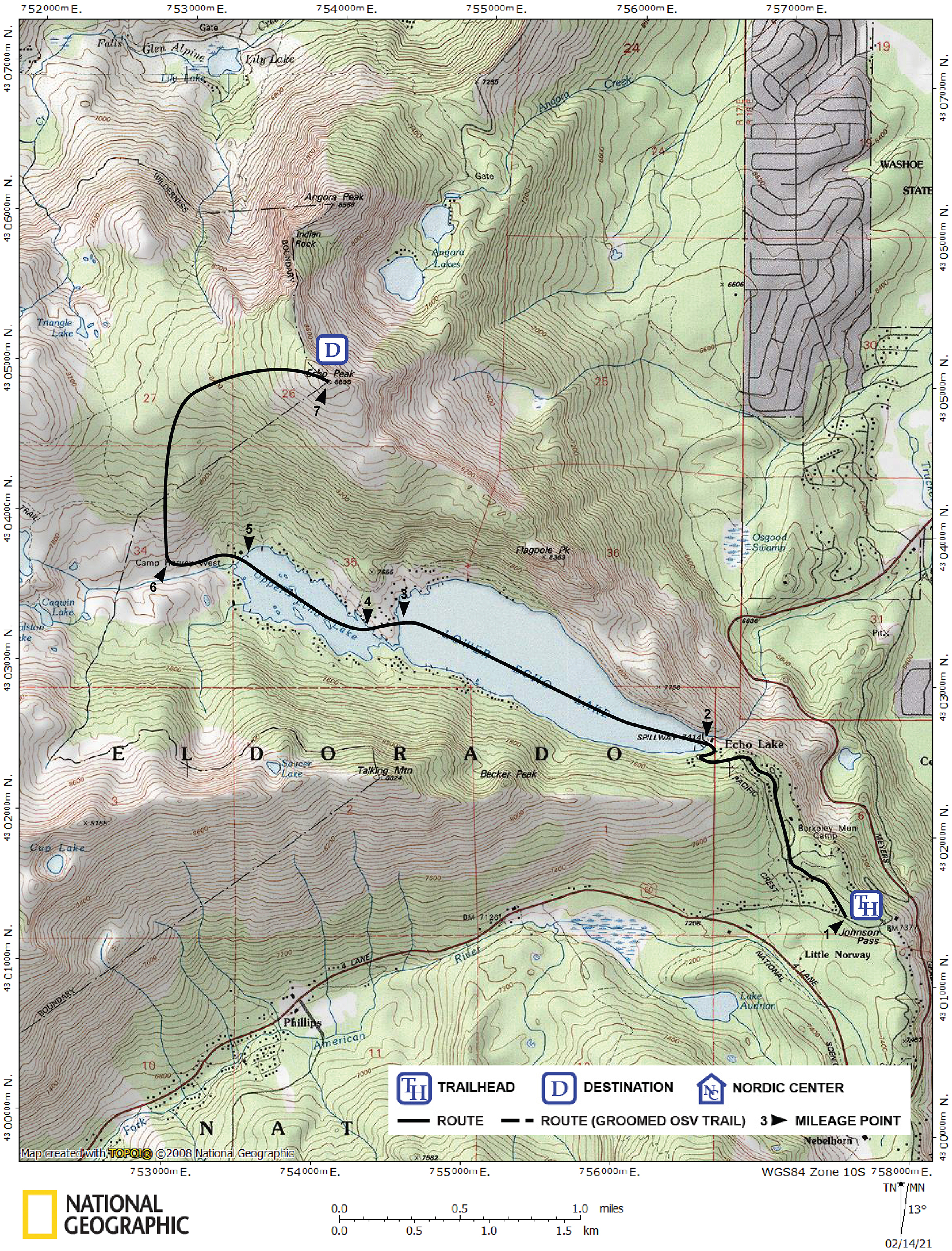
Mileage Log ![]()
Numbers in parentheses
correspond to mileage points on map
Waypoint 1 to 2
Miles: 0.0 - 1.2
Elevation change: +150, -100 feet
Locate the snow-covered road and trailhead (1)opposite the entrance to the Sno-Park and follow the road northwest for 1.2 miles until you reach the southeast end of Lower Echo Lake (2). You can expect a gradual climb followed by a short, steep descent to the lake. Stay left on the obvious main road if you see any road junctions.
Waypoint 2 to 3
Miles: 1.2 - 2.6
Elevation change: Nil
If it is safe, ski northwest across the lower lake for 1.4 miles until your each its northwest end (3).
Waypoint 3 to 4
Miles: 2.6 - 2.7
Elevation change: Nil
Ski west for 0.1 mile until you reach the southeast end of Upper Echo Lake (4).
Waypoint 4 to 5
Miles: 2.7 - 3.3
Elevation change: Nil
Ski northwest across the upper lake for 0.6 mile until you reach its northwest end (5).
Waypoint 5 to 6
Miles: 3.3 - 3.7
Elevation change: +150 feet
Ski west for 0.4 mile until the terrain to the north becomes less steep (6) (there is no landmark).
Waypoint 6 to 7
Miles: 3.7 - 5.1
Elevation change: +1300 feet
Ski in an arc, first north and ending east, for 1.4 miles until you reach the summit of Echo Peak (7).

Looking north from Echo Peak
Return to trailhead
Miles: 5.1 - 10.2
Elevation change: +100, -1600 feet
Retrace the route for 5.1 miles back to the trailhead (1).