
Summary ![]()
| Difficulty | 4 intermediate-advanced |
| Length | 5.0 miles round trip |
| Starting Elevation |
8850 feet |
| Cumulative Elevation Change |
+1100, -1100 round trip |
| Navigation | Road and map |
| Time | Most of a day |
| Season | January through early April |
| Snowmobiles Use | Not permitted on the mile of road closest to the highway nor anywhere in the off road part of the tour. Low elsewhere on road. [Please report illegal use of snowmobiles in this area.] |
| USGS Topo | 7.5' series, Mount Rose |
| Start | Highway 431, 7.8 miles northeast of Highway 28 and 0.3 mile southwest of Mt. Rose Summit. A building and snow-covered road are located on the north side of the highway. Parking is limited; as an alternative start the tour at the parking area located 0.4 mile to the west. |
Description ![]()
You should choose to traverse the ridge of which Tamarack Peak is the highest point for the unique experience but in doing so you will in all likelihood spend time climbing up some crappy snow or even carrying your skis over some short stretches of snow-barren ground. It's still a great trip.

Summit of Tamarack Peak
But if you simply want to gain the view from the summit and enjoy 850 feet of modestly steep continuous gradient on the descent, then you probably will find the Tamarack Peak Direct tour more to your liking.
This loop tour is a combination of skiing on a rather well-used road, climbing the relatively narrow ridge, and the final descent down the south-facing slope where the snow turns to corn quickly. Also the trees are scattered on the descent, which makes for fun turning through them. But don't go here when it has been windy; without any protection from westerlies the slopes become icy just as quickly.
From the route up and down, as well as obviously from the summit of Tamarack Peak, the views are superb. To the south and southwest are Tahoe Meadows, Lake Tahoe and the ridges above Ginny Lake.
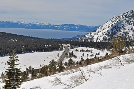
Tahoe Meadows and Lake Tahoe from the road to Relay Ridge

Lake Tahoe far left; Ginny Lake area and Slab Cliffs far right
To the west is Relay Ridge, the border of the Mount Rose Wilderness, and to the north is Mount Rose, the highest peak in the greater Lake Tahoe area at 10,776 feet. But don't be surprised if the face of Mount Rose is barren.

Relay Ridge

Mount Rose
Finally to the east is Washoe Valley far below.

Washoe Valley
A final note about the section of the tour along the road to Relay Ridge is prudent; it is heavily used, but don't be discouraged; you will probably be blazing your own trail once you leave it and begin to climb. You may also find lots of tracks on the summit. These come from the telemark skiers, AT skiers and boarders who ascend a different route for the opportunity to ski down one of the steep routes on the northeast side of the peak.
Mileage Log ![]()
Numbers in parentheses
correspond to mileage points on map
Waypoint 1 to 2
Miles: 0.0 - 2.5
Elevation change: +550 feet
From the trailhead (1) ski west on the snow-covered road, which gradually turns north up the Third Creek drainage, for a total of 2.5 miles until you reach a saddle (2). The saddle separates Third Creek and Galena Creek.
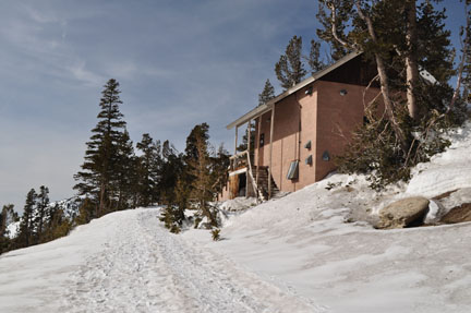
Building at trailhead
Waypoint 2 to 3
Miles: 2.5 - 2.7
Elevation change: +300 feet
Ascend the narrow ridge to the east (right) for 0.2 mile until you reach a red rock outcropping (3). You can start the ascent slightly on the north side of the ridge where you might find more snow but you will want to move onto the ridge shortly.

Red rock outcropping and sparse snow on ridge
Waypoint 3 to 4
Miles: 2.7 - 3.2
Elevation change: +250 feet
Continue southeast on the ridge, shortly cross a broad saddle and finally pick your way through and around wind ravaged trees for a total of 0.5 mile until you reach the summit of Tamarack Peak (4).

Summit of Tamarack Peak from broad saddle

Lake Tahoe from Tamarack Peak
Waypoint 4 to 5
Miles: 3.2 - 4.0
Elevation change: -850 feet
Descend southeast for 0.4 mile and then south for 0.4 mile until you reach the road to Relay Ridge (5).
Waypoint 5 to 1
Miles: 4.0 - 5.0
Elevation change: -250 feet
Ski east (left) on the road for 1.0 mile until you reach the trailhead (1).
