Summary ![]()
| Difficulty | 3 Intermediate |
| Length | 3.4 miles round trip |
| Starting Elevation |
7200 feet |
| Cumulative Elevation Change |
+400, -400 round trip |
| Navigation | Road and map |
| Time | Half day |
| Season | December through mid-April |
| Snowmobiles Use | Low. Although snowmobiles are permitted in the Summit Lake area, riding from mileage point 2 to Summit Lake would require going through an area closed to snowmobile use. [Please report illegal use of snowmobiles in this area.] |
| USGS Topo | 7.5' series, Norden |
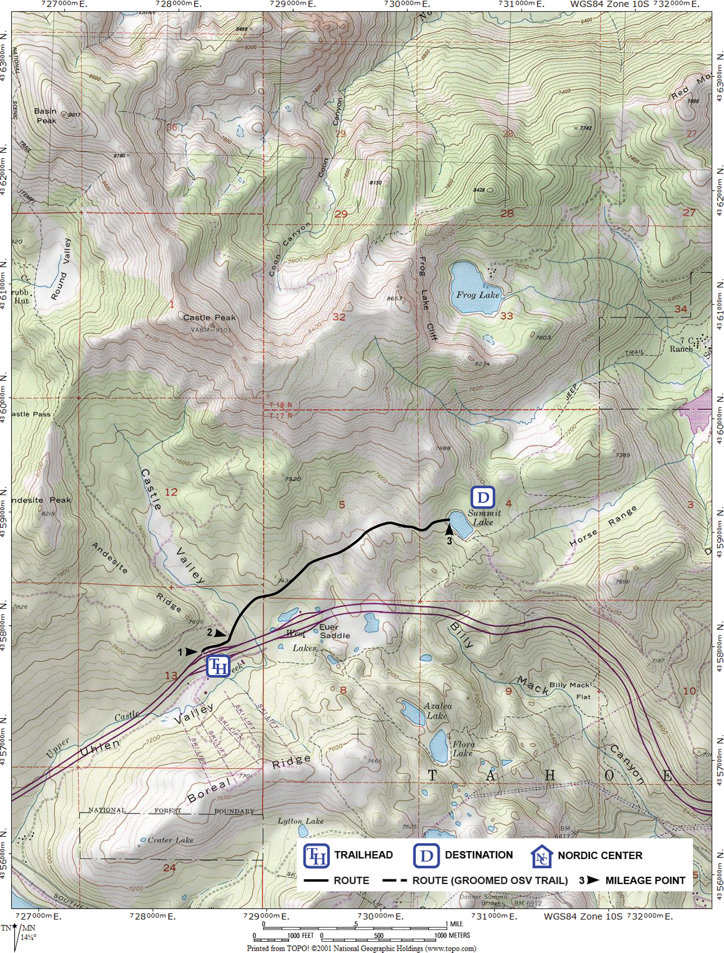
| Start | The plowed loading zone on the north side of Interstate 80 at the Castle Peak Area and Boreal Ridge exit. Parking is at the Donner Pass Sno-Park located at the east end of the frontage road on the south side of the interstate at the same exit. |
Description ![]()
You will find excellent touring terrain to the north of Interstate 80 between the trailhead and Summit Lake. This mostly open, rolling terrain is an ideal place to enjoy an afternoon. Nearby slopes can provide hours of pleasurable telemark practice. There also are countless spots to enjoy a lunch with a dramatic view.
Surprisingly, unlike its neighboring tours to Castle Valley and Round Valley, the area covered in this tour to Summit Lake is much less traveled. In fact, even when traveled by others, you can find an untracked route since there is no single, distinct one.
A couple of words of caution. The first part of the tour, after leaving the snow-covered road, can be plagued by many small rocky gullies if there is insufficient snow. Also, finding Summit Lake, hidden within dense timber, is not a simple task. But regardless of whether you reach the lake or not, the area through which this tour passes is well worth a visit.
The more difficult tour to Frog Lake Cliff also passes through this area.
Mileage Log ![]()
Numbers in parentheses
correspond to mileage points on map
Waypoint 1 to 2
Miles: 0.0 - 0.2
Elevation change: +50 feet
From the trailhead (1) ski east on the snow-covered road that parallels the interstate for 0.2 mile until you reach the location where the road turns northwest (left) (2).
Waypoint 2 to 3
Miles: 0.2 - 1.7
Elevation change: +250, -100 feet
Leave the road and ski northeast for 1.5 miles until you reach Summit Lake (3). You will need to use a map to navigate because there are no markers or roads to follow. In general you should be aiming for a point at the end of the ridge that extends down to the southeast from Castle Peak. Just before reaching the lake you will cross a very small spur of the ridge. If all else fails, climb up above the trees to spot Summit Lake.
Return to trailhead
Miles: 1.7 - 3.4
Elevation change: +100, -300 feet
Retrace the initial route for 1.7 miles back to the trailhead (1).