Summary ![]()
| Difficulty | 5 Advanced |
| Length | 11.7 miles round trip |
| Starting Elevation |
6750 feet |
| Cumulative Elevation Change |
+2100, -2100 round trip |
| Navigation | Road, map and compass |
| Time | Very long day |
| Season | December through April |
| Snowmobiles Use | Not permitted [Please report illegal use of snowmobiles in this area.] |
| USGS Topo | 7.5' series, Lassen Peak, Reading Peak |
| Start | Kohm Yah-mah-nee Visitor Center located one mile past the Southwest Entrance Station. |
Description ![]()
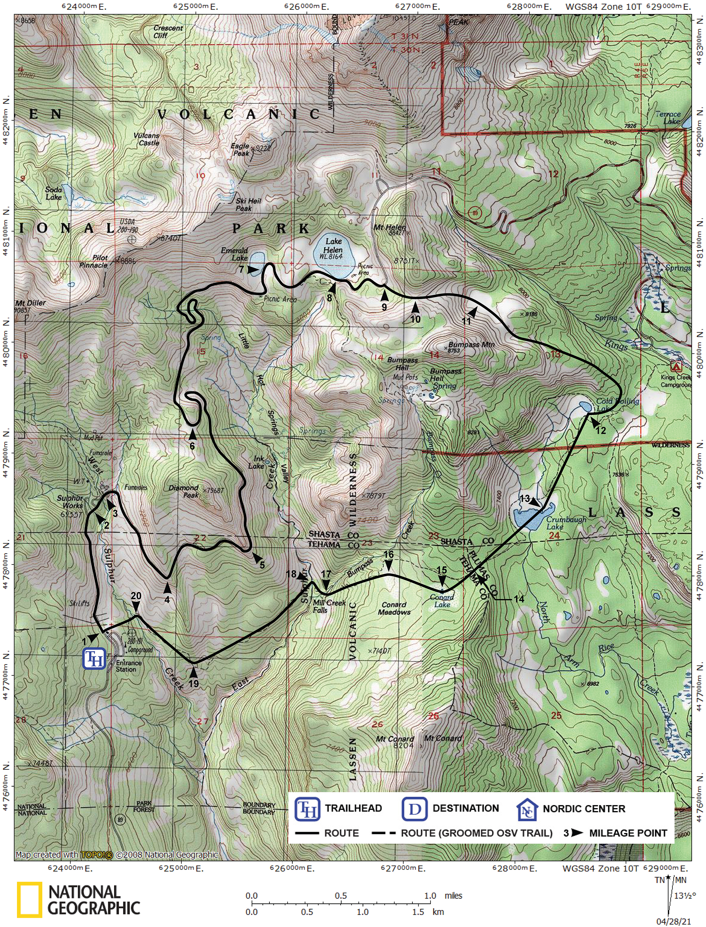
The Conard Lake Loop covers parts of the Lassen Park Road, Cold Boiling and Crumbaugh Lakes, and Conard Lake and Meadows which are seldom visited in winter. It is a time and energy consuming tour for even hardy skiers. The tour ends with a descent of some of the most difficult terrain described in the Lassen area. It is a tour for the advanced skier looking for an adventure. If you need to think twice about whether you can do it, you probably should not be doing it.
There are pros and cons for skiing this loop in the direction described here (clockwise) or in the opposite direction (counter-clockwise). In the clockwise direction most of the uphill climb is on Lassen Park Road while the downhill run is in the backcountry. When skiing in this direction, plan to start very early and finish the first 6.2 miles of road travel in three hours or less. The later task of route-finding and other difficulties may take lots of time.
The advantage of skiing this tour in the counter-clockwise direction is that the most difficult sections occur early. If you encounter difficulties and need to retrace your tracks, you have a shorter distance to return. You will also find that in this direction the very, very steep terrain through trees is uphill.
This tour was scouted long before the proliferation of information by way of the internet, which limited the information available. One went out, explored and dealt with the difficulties that were faced. As a result, the route described in the printed form, Ski Tours in Lassen Volcanic National Park and Vicinity, described an extremely difficult and sometimes dangerous crossing of East Sulphur Creek.
The tour described in this electronic version crosses two bridges in the vicinity of East Sulphur Creek; one over Bumpass Creek and one over East Sulphur Creek. Still the slopes in the areas of these creek crossings are very steep and wooded. A third bridge, over West Sulphur Creek, was described in the original guide.
For meeting the challenges of this adventurous tour, you will be rewarded with the pride and satisfaction of accomplishment.
Mileage Log ![]()
Numbers in parentheses
correspond to mileage points on map
Waypoint 1 to 2
Miles: 0.0 - 0.7
Elevation change: +200
From the trailhead (1) ski north on Lassen Park Road for 0.7 mile until you reach the bridge (2) across West Sulphur Creek. The bridge is the turnoff point for Ridge Lakes tour.
Waypoint 2 to 3
Miles: 0.7 - 0.8
Elevation change: +50
Ski northeast on Lassen Park Road for 0.1 mile until you reach the Sulphur Works (3). At the Sulphur Works, an active hydrothermal area, you can hike the short nature trail (boardwalks) located on the north (left) side of the road. The Sulphur Works Cutoff tour also begins here. The cutoff shortens the tour to Emerald Lake and Lake Helen by 2.1 miles and bypasses the portion of Lassen Park Road east of Diamond Peak that is prone to avalanche.
Waypoint 3 to 4
Miles: 0.8 - 1.5
Elevation change: +150
Ski southeast on Lassen Park Road for 0.7 mile until you reach Brokeoff Mountain Viewpoint (4). The viewpoint, also called Windy Point, offers an excellent view to the west of Brokeoff Mountain, the largest remaining part of Mt. Tehama, an 11,000-foot volcano.
Waypoint 4 to 5
Miles: 1.5 - 2.1
Elevation change: +150
Ski generally east on Lassen Park Road for 0.6 mile until you reach Diamond Point (5). Diamond Point affords a good view to the southeast of the Mill Creek drainage and Mt. Conard.
Waypoint 5 to 6
Miles: 2.1 - 3.5
Elevation change: +350
Ski north on Lassen Park Road for 1.1 miles to a 180 degree turn in the road and then for 0.3 mile until you reach Diamond Peak Saddle (6). The saddle is located at the top of an S-turn where the road travels along a ridge-like area. The Sulphur Works Cutoff intersects the road 0.1 mile past here.
Waypoint 6 to 7
Miles: 3.5 - 5.3
Elevation change: +500
Ski north on Lassen Park Road for 0.8 mile until you reach the start of an S-turn, then ski 0.3 mile through the S-turn, and then generally east for 0.7 mile until you reach Emerald Lake (7). Emerald Lake is the first good snow camping site along Lassen Park Road.
Waypoint 7 to 8
Miles: 5.3 - 5.9
Elevation change: +50
Ski east on Lassen Park Road for 0.6 mile until you reach Lake Helen (8). If you lose sight of the road at Emerald Lake, ski east until you reach Lake Helen where you will be able to pick up the road again.
Waypoint 8 to 9
Miles: 5.9 - 6.2
Elevation change: +150
Ski generally east on Lassen Park Road for 0.3 mile until you reach the location where the road turns north (left) (9). The turn in the road is the turnoff point for the Bumpass Hell tour and the start of the Lake Helen Cutoff tour, which shortens the tour on the park road by 3.1 miles.
Waypoint 9 to 10
Miles: 6.2 - 6.4
Elevation change: +100
Leave the road and climb east for 0.2 mile until you reach a saddle (10).
Waypoint 10 to 11
Miles: 6.4 - 6.9
Elevation change: -300
Ski east for 0.5 mile until you reach the center of a large, open, flat area (11). You will see a small knob at the east end of the flat area.
Waypoint 11 to 12
Miles: 6.9 - 7.9
Elevation change: -700
Ski southeast, pass the small knob to its south (right), descend the southeast ridge of Bumpass Mountain, and when the terrain becomes relatively level loop south, southwest and then west for a total of 1.0 mile until you reach Cold Boiling Lake (12). Depending on your exact route, you may get views of both Cold Boiling and Crumbaugh Lakes as you descend the ridge.
Waypoint 12 to 13
Miles: 7.9 - 8.6
Elevation change: -200
Ski southwest generally following the Cold Boiling Lake drainage for 0.7 mile until you reach Crumbaugh Lake (13). Do not ski beneath the steep southeast slopes of Bumpass Mountain when avalanche conditions exist.
Waypoint 13 to 14
Miles: 8.6 - 9.2
Elevation change: +50
Ski southwest for 0.6 mile until you reach the very low saddle (14) northeast of Conard Lake.
Waypoint 14 to 15
Miles: 9.2 - 9.4
Elevation change: -100
Ski southwest for 0.2 mile until you reach Conard Lake and (Upper) Meadow (15).
Waypoint 15 to 16
Miles: 9.4 - 9.7
Elevation change: -100
Ski west through trees for 0.3 mile until you reach Conard (Lower) Meadow (16).
Waypoint 16 to 17
Miles: 9.7 - 10.1
Elevation change: -500
Descend slightly south of west at an increasing angle through very dense woods for 0.4 mile until you reach a bridge across Bumpass Creek (17).
Waypoint 17 to 18
Miles: 10.1 - 10.2
Elevation change: -50
Ski northwest for 0.1 mile until you reach a bridge across East Sulphur Creek (18).
Waypoint 18 to 19
Miles: 10.2 - 11.0
Elevation change: -150
Ski southwest for 0.8 mile until you reach the south end of a steep ridge (19).
Waypoint 19 to 20
Miles: 11.0 - 11.5
Elevation change: +200
Ski northwest parallel to West Sulphur Creek for 0.5 mile until you reach the foot bridge (7) across the creek.
Waypoint 20 to 1
Miles: 11.5 - 11.7
Elevation change: +200
Climb west for 0.2 mile to the visitor center (1). Be aware that the foot bridge across West Sulphur Creek is narrow and walking across it may be tricky when it is covered with snow.