Summary ![]()
| Difficulty | 2 Beginner-intermediate |
| Length | 1.9 miles round trip |
| Starting Elevation |
6750 feet |
| Cumulative Elevation Change |
+450, -450 round trip |
| Navigation | Road and map |
| Time | Few hours |
| Season | December through April |
| Snowmobiles Use | Not permitted [Please report illegal use of snowmobiles in this area.] |
| USGS Topo | 7.5' series, Lassen Peak |
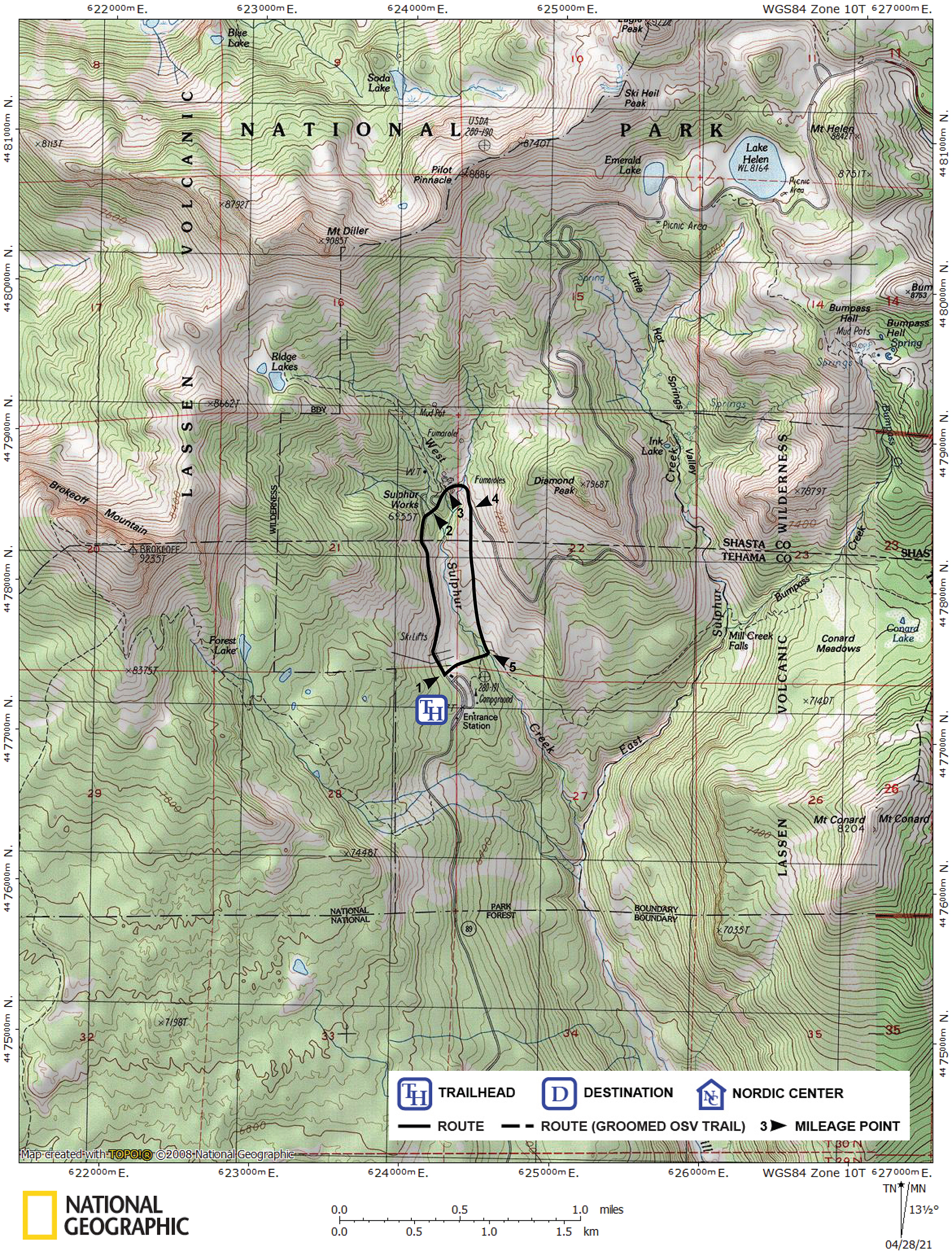
| Start | Kohm Yah-mah-nee Visitor Center located one mile past the Southwest Entrance Station. |
Description ![]()
The high peaks and steep canyons that make Lassen Volcanic Park's southwest entrance so magnificent also make the ski touring in the area more difficult than elsewhere. Other than skiing on Lassen Park Road, the Sulphur Works Loop tour is the only tour for novice skiers in this area.
From the visitor center, this tour follows Lassen Park Road for almost one mile to the Sulphur Works; you then return to the visitor center by traveling parallel to the park road. You can create a longer tour by skiing farther on the park road and returning via the parallel route.
Be aware that the foot bridge used to cross the West Sulphur Creek on your return is narrow and walking across it may be tricky when it is covered with snow.
Mileage Log ![]()
Numbers in parentheses
correspond to mileage points on map
Waypoint 1 to 2
Miles: 0.0 - 0.7
Elevation change: +200
From the trailhead (1) ski north on Lassen Park Road for 0.7 mile until you reach the bridge (2) across West Sulphur Creek. The bridge is the turnoff point for Ridge Lakes tour.
Waypoint 2 to 3
Miles: 0.7 - 0.8
Elevation change: +50
Ski northeast on Lassen Park Road for 0.1 mile until you reach the Sulphur Works (3). At the Sulphur Works, an active hydrothermal area, you can hike the short nature trail (boardwalks) located on the north (left) side of the road. The Sulphur Works Cutoff tour also begins here. The cutoff shortens the tour to Emerald Lake and Lake Helen by 2.1 miles and bypasses the portion of Lassen Park Road east of Diamond Peak that is prone to avalanche.
Waypoint 3 to 4
Miles: 0.8 - 1.0
Elevation change: +0
Ski east on Lassen Park Road for 0.1 mile until you reach the North Fork of West Sulphur Crrek and then continue south for 0.1 mile until you reach a point where you can easily descend to the south (4) on the southwest (right) side of the road.
Waypoint 4 to 5
Miles: 1.0 - 1.7
Elevation change: -450
Ski south and parallel to the park road and West Sulphur Creek for 0.7 mile until you reach a foot bridge (5) across the creek. There is no need to stay close to the creek as you descend through this wide-open area. However, when the visitor center is almost directly opposite the creek you must move close to the creek and look carefully for the bridge.
Waypoint 5 to 1
Miles: 1.7 - 1.9
Elevation change: +200
Climb west for 0.2 mile to the visitor center (1).