Summary ![]()
| Difficulty | 1-3 Beginner-intermediate | ||
| Length | Up to 19.0 miles round trip | ||
| Starting Elevation |
6200 feet | ||
| Cumulative Elevation Change |
Up to +1350, -1350 round trip | ||
| Navigation | Road | ||
| Time | Up to very long day | ||
| Season | Mid-December through early April | ||
| Snowmobiles Use | Not permitted [Please report illegal use of snowmobiles in this area.] | ||
| USGS Topo |
|
||
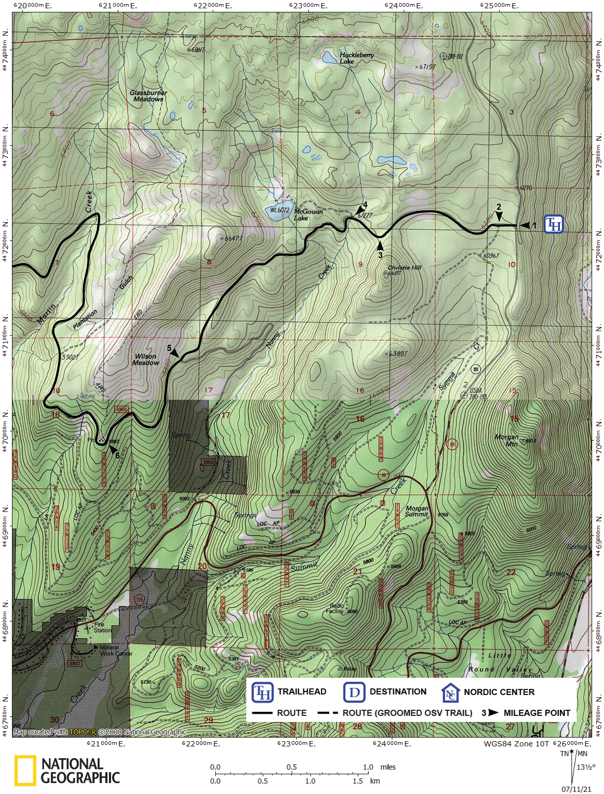
| Start | McGowan Road Trailhead on Highway 89, 2.0 miles north of the junction of Highways 36 and 89, and 3.5 miles south of the Kohm Yah-mah-nee Visitor Center. There is a turnout, parking space, and the trailhead on the west side of the highway. | ||
| End | Junction of McGowan Road and Viola Road. There is no vehicle access to this point. Return via the same route or one of the other routes described in this guide. |
Description ![]()
Except for the Southwest Entrance to the park itself, there is good reason for the McGowan Road Trailhead being the most popular trailhead for cross-country skiers in the Lassen area. McGowan Road is the main access route into an area that has good terrain for touring. It is also one of the roads in the area designated as a Nordic trail where snowmobiles are prohibited.
Ski as far as you desire and then retrace your route. Or you can branch off in a number of directions, and the roads in this area can be linked to create interesting loop and one-way tours.
Mileage Log ![]()
Numbers in parentheses
correspond to mileage points on map
Waypoint 1 to 2
Miles: 0.0 - 0.1
Elevation change: +0
Ski west on McGowan Road for 0.1 mile until you reach the junction with Christie Hill Road (2), which is on the south (left) side of McGowan Road.
Waypoint 2 to 3
Miles: 0.1 -1.0
Elevation change: +50
Ski generally west (straight) on McGowan Road for 0.9 mile until you reach the location where the road begins to descend (3). Beyond this point McGowan Road drops steadily for 1.9 miles and for beginners may be difficult when icy.
Waypoint 3 to 4
Miles: 1.0 - 1.2
Elevation change: -100
Ski northwest on McGowan Road for 0.2 mile until you reach the McGowan Lake turnoff (4), which is on the north (right) side of McGowan Road. The turnoff to McGowan Lake is easily missed if you are skiing fast.
Waypoint 4 to 5
Miles: 1.2 - 2.9
Elevation change: -450
Ski generally southwest (straight) on McGowan Road for 1.7 miles until you reach the junction with Nanny Creek Road (5), which is on the southeast (left) side of McGowan Road.
Waypoint 5 to 6
Miles: 2.9 - 3.9
Elevation change: +150
Ski generally southwest (straight) on McGowan Road for 1.0 miles until you reach a road junction (6). At the junction the fairly obvious road on the north (right) side of McGowan Road is part of the Plantation Ridge tour and the McGowan Lake and Plantation Ridge Loop tour.
Waypoint 6 to 7
Miles: 3.9 - 7.6
Elevation change: +400
Ski northwest (straight), north and then southwest on McGowan Road for a total of 3.7 miles until you reach a road junction (7). The major road on the north (right) side of McGowan Road is not especially interesting. The lesser road on the south (left) side of McGowan Road is part of the Battle Creek Overlook Via McGowan Road tour.
Waypoint 7 to 8
Miles: 7.6 - 9.5
Elevation change: -200
Ski northwest (straight) on McGowan Road for 1.9 miles until you reach Viola Road (8). This is the end of McGowan Road.
Return to trailhead
Miles: 9.5 - 19.0
Elevation change: +750, -600
Retrace the route for 9.5 miles back to the trailhead (1).