Summary ![]()
| Difficulty | 2 Beginner-intermediate |
| Length | 2.1 miles one-way to McGowan Road |
| Starting Elevation |
5100 feet |
| Cumulative Elevation Change |
+600 one-way to McGowan Road |
| Navigation | Road |
| Time | Short one-way |
| Season | Mid-December through early April |
| Snowmobiles Use | Not permitted [Please report illegal use of snowmobiles in this area.] |
| USGS Topo | 7.5' series, Lassen Peak, Mineral |
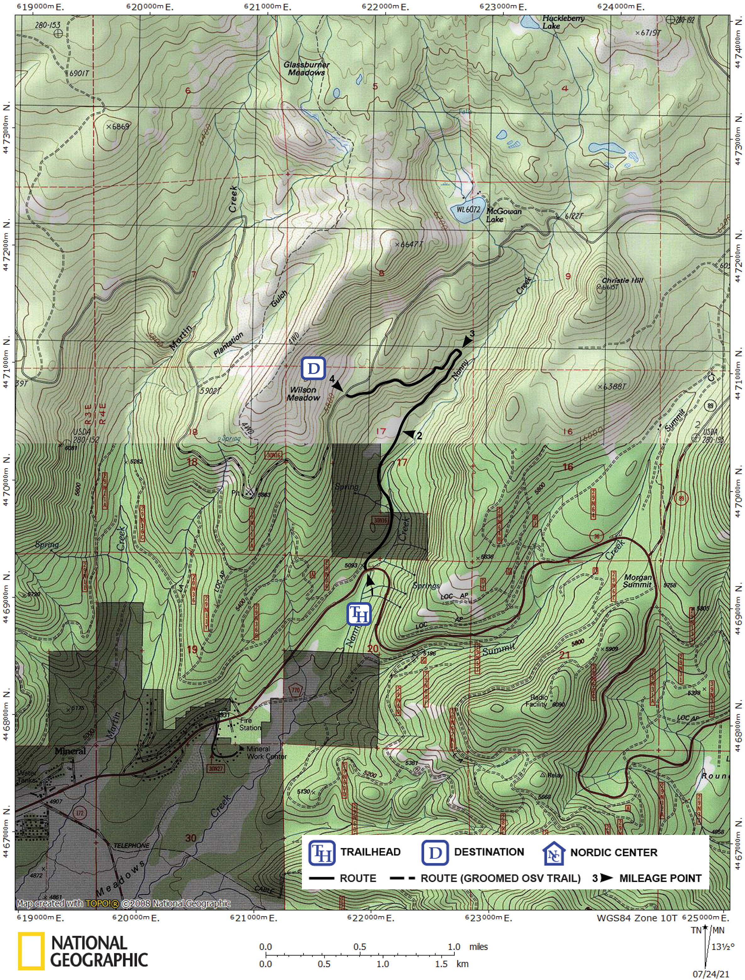
| Start | Nanny Creek Road Trailhead on Highway 36, 2.0 miles east of the Mineral Post Office and 2.3 miles west of the junction of highways 36 and 89. |
| End | Junction of Nanny Creek Road and McGowan Road. There is no vehicle access to this point. Return via the same route or one of the other routes described in this guide. |
Description ![]()
Nanny Creek Road makes an excellent tour by itself, but you can combine it with other roads in the area to form a tailor-made one-way tour. For example, you can combine it with the Eight-Nine Run and McGowan Road tours or with the Christie Hill Road and McGowan Road tours to form one-way tours.
If you begin by skiing the Eighty-Nine Run, then use McGowan Road to connect with Nanny Creek Road, 150 feet of elevation gain rewards you with 1500 feet of elevation loss. Save this tour for a cold winter storm when the powder is good all the way to the bottom.
The Nancy Creek Road tour is popular because it is one of the main three roads in the area designated as Nordic trails and is closed to snowmobiles. The other two are Christie Hill Road and McGowan Road.
Mileage Log ![]()
Numbers in parentheses
correspond to mileage points on map
Waypoint 1 to 2
Miles: 0.0 - 0.8
Elevation change: +250
From the trailhead (1), ski north on Nanny Creek Road for 0.8 mile until you reach a small meadow (2). Although the name Wilson Meadow is shown farther to the northwest and on the other side of McGowan Road, it is believed that the meadow here is actually Wilson Meadow.
Immediately after leaving the trailhead, you will pass a lessor road to the west (left) that turns southwest. You continue north (straight) on the main road.
Waypoint 2 to 3
Miles: 0.8 - 1.4
Elevation change: +150
Ski northeast on Nanny Creek Road for 0.6 mile until you reach a 180 degree turn (3).
Waypoint 3 to 4
Miles: 1.4 - 2.1
Elevation change: +200
Ski southwest and then west on Nanny Creek Road for 0.7-mile until you reach McGowan Road (4).