Summary ![]()
| Difficulty | 3 Intermediate |
| Length | 10.4 miles round trip |
| Starting Elevation |
8600 feet |
| Cumulative Elevation Change |
+1700, 1700 round trip |
| Navigation | Road and marked trail (compass may be useful) |
| Time | Full day |
| Season | Late November through early May |
| Snowmobiles Use | Not permitted through mid-April. Moderate after mid-April to Mammoth Pass, but not permitted west of Mammoth Pass. Contact Forest Service for transition date. [Please report illegal use of snowmobiles in this area.] |
| USGS Topo | 7.5 series, Crystal Crag, Bloody Mountain |
| Start | Lake Mary Road near Twin Lakes where the road is no longer plowed. The plowed parking area is just past (south of) the turn to Tamarack Lodge and Resort. |
Description ![]()
Red Cones, the volcanic cinder cones located to the west of Mammoth Crest and overlooking the Middle Fork of the San Joaquin River drainage, make an excellent destination. This tour leads to the north cone from which you have a superb view of the river drainage, the Minarets, Mount Ritter, Banner Peak, and the San Joaquin Ridge.
Mileage Log ![]()
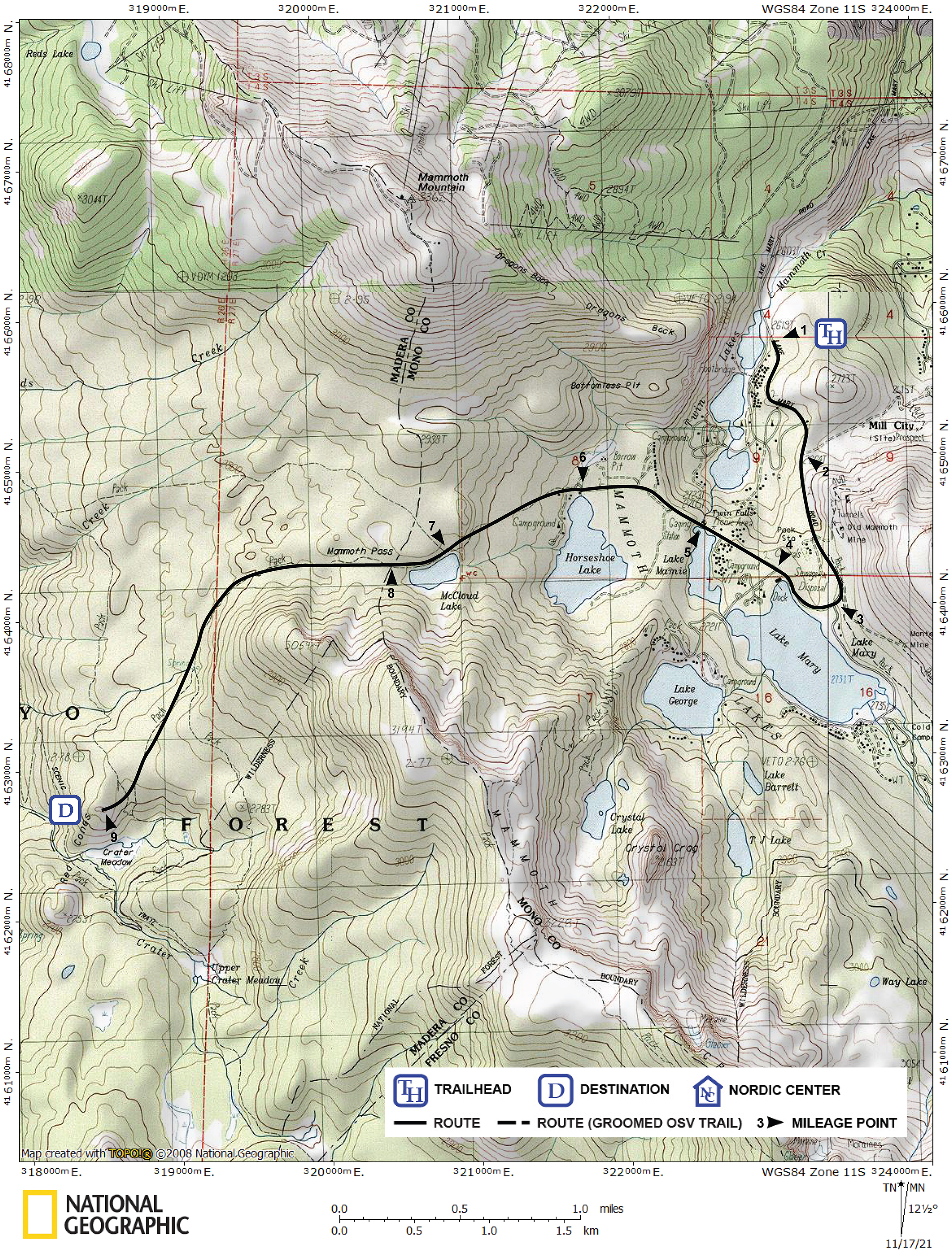
Numbers in parentheses
correspond to mileage points on map
Waypoint 1 to 2
Miles: 0.0 - 0.6
Elevation change: +150
From the trailhead (1), ski south on Lake Mary Road for 0.6 mile until you reach the turnoff (2) on the east (left) side of the road to the site of the mining town of Old Mammoth and present-day Old Mammoth.
Waypoint 2 to 3
Miles: 0.6 - 1.3
Elevation change: +300, -50
Continue south on Lake Mary Road for 0.7 mile until you reach the first turnoff to Lake Mary (3).
Waypoint 3 to 4
Miles: 1.3 - 1.6
Elevation change: -50
Continue west and then northwest on Lake Mary Road for a total of 0.3 mile until you reach the second turnoff to Lake Mary (4).
Waypoint 4 to 5
Miles: 1.6 - 1.9
Elevation change: -50
Continue northwest on Lake Mary Road for 0.3 mile until you reach an overlook above Twin Lakes (5). This point is at the north end of Lake Marnie.
Waypoint 5 to 6
Miles: 1.9 - 2.5
Elevation change: +50
Continue northwest and then west on Lake Mary Road for a total of 0.6 mile until you reach Horseshoe Lake (6). Do not be tempted to seek refuge out of stormy weather in the well of the trees or structures located near the lake. Escaping toxic gases from the extinct volcano that formed this area can accumulate in these depressions.
Waypoint 6 to 7
Miles: 2.5 - 3.1
Elevation change: +400
Beyond Horseshoe Lake, the route follows a marked trail, the start of which is not obvious. Look carefully for the marker on the road's southwest end. This is the southwest end of the second parking loop.
In reality, following the marked trail may be more difficult and time consuming that it is worth. This is an ideal opportunity to practice using a compass. Take a bearing at Horseshoe Lake and follow it for the next 0.6 mile. You will be rewarded with learning a new skill.
Ascend southwest for 0.6 mile until you reach McCloud Lake (7).
Waypoint 7 to 8
Miles: 3.1 - 3.4
Elevation change: +0
Follow the north side of McCloud Lake to the west and then continue west for a total of 0.3 mile until you reach broad Mammoth Pass (8).
Waypoint 8 to 9
Miles: 3.4 - 5.2
Elevation change: +150, -500
Follow the marked trail as it traverses west and then southwest around Peak 10,005 for a total of 1.7 miles to the base of the north Red Cone and then ascend west for 0.1 mile to the summit of the north Red Cone (9).
Return to trailhead
Miles: 5.2 - 10.4
Elevation change: +650, - 1050
Retrace the route for 5.2 miles back to the trailhead (1).