Summary ![]()
| Difficulty | 4 Intermediate-advanced |
| Length | 7.8 miles one-way |
| Starting Elevation |
8050 feet |
| Cumulative Elevation Change |
+2000, -2350 one-way |
| Navigation | Road, ski area trail, map and compass |
| Time | Full day |
| Season | December through April |
| Snowmobiles Use | Not permitted [Please report illegal use of snowmobiles in this area.] |
| USGS Topo | 7.5' series, June Lake, Mammoth Mountain |
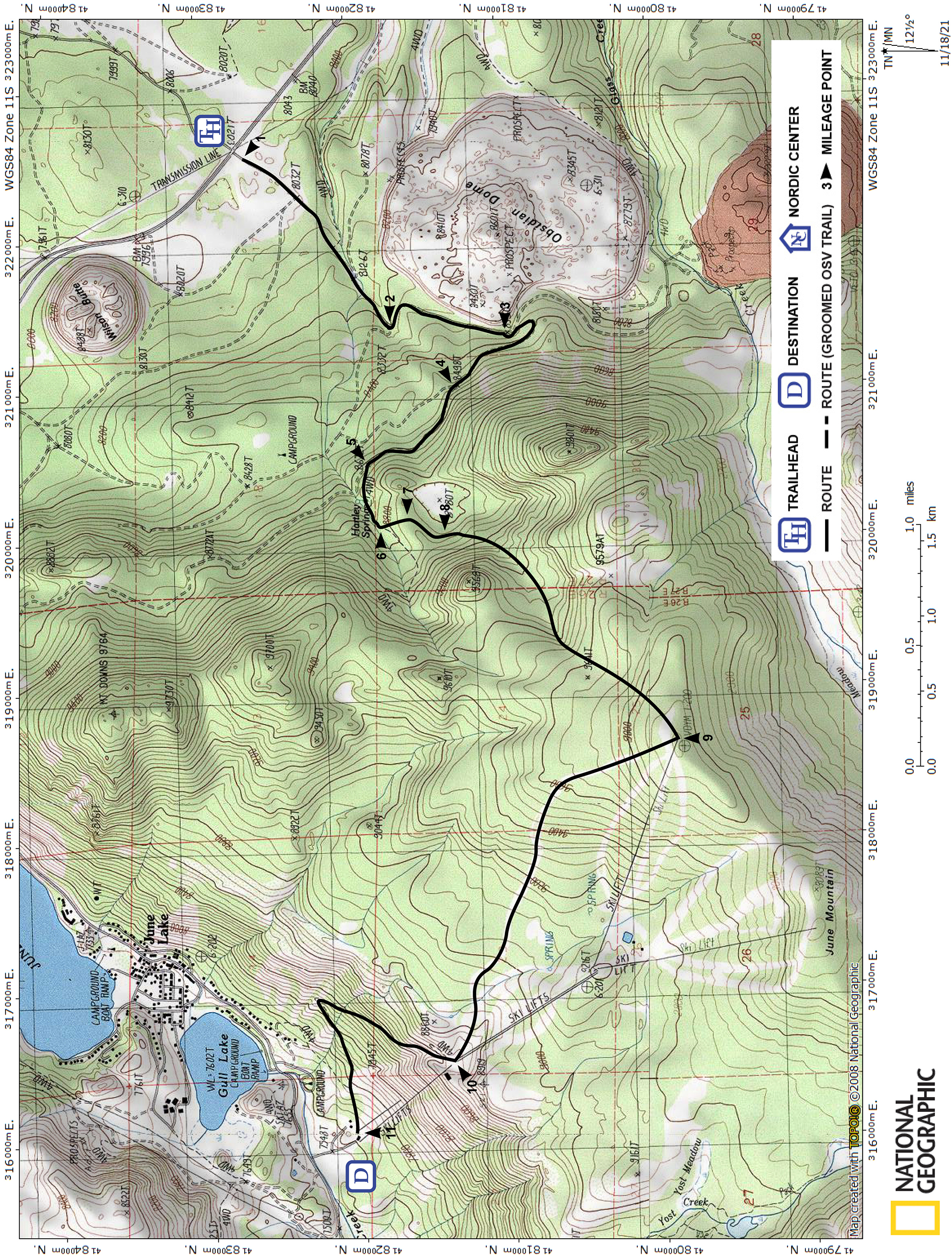
| Start | Highway 395 at Obsidian Dome Road, 3.8 miles south of June Lake Junction (June Lake Loop South Entrance) and 11. 7 miles north of Mammoth Junction (junction of Highways 395 and 203). |
| End | June Mountain Ski Area parking lot on the June Lake Loop road, 1.1 miles southwest of the town of June Lake.. |
Description ![]()
This tour presents a variety of ski terrain. It begins with a straightforward, steady climb on snow-covered roads to a secluded bowl. Beyond the bowl and the roads, the route ascends a very steep canyon to the top of a June Mountain Ski Area chairlift. From the top the dramatic panorama includes the west end of Mono Lake, the White Mountains, the Sierra Crest from the Koip Crest to the San Joaquin Ridge, and the real eye-catcher, Mt. Wood, which lies just east of the crest.
Unfortunately, the ski area creates an atmosphere that is far from serene; however, one of the best features of this tour is the final downhill run on the ski area slopes to the June Meadows Chalet — almost two miles of telemark turns.
The final descent from June Meadows Chalet to the end of the tour is a 1050-foot descent down a steep, narrow ski trail. As an alternative, before beginning the tour, you can go to the Lower Ticket Office and purchase a scenic ride ticket that entitles you to one round trip on Chairlift J6. Take the ticket with you and use it to descend in the afternoon.
If you do this tour when the ski area is not in operation (usually before Thanksgiving and after Easter), or if you reach the June Meadows Chalet after the lift closes, you will have to ski down.
Mileage Log ![]()
Numbers in parentheses
correspond to mileage points on map
Waypoint 1 -2
Miles: 0.0 - 1.0
Elevation change: +150
From the trailhead (1), ski southwest on Obsidian Dome Road for 1.0 mile until you reach a road junction (2). The fork to the west (right) is part of the Hartley Springs Campground Loop tour. The tour described here continues on the forth to the east (left).
Waypoint 2 - 3
Miles: 1.0 - 1.5
Elevation change: +150
Continue on the fork to the east (left) and shortly turn south for a total of 0.5 mile until you reach a very obscure road junction (3) where the obvious road turns southeast (left). At this point you are very close to Obsidian Dome and on its west side. Refer to the Obsidian Dome tour if you want to explore the summit.
Waypoint 3 - 4
Miles: 1.5 - 2.1
Elevation change: +200
Do not follow the obvious road. Ski south (straight) on an obscure road for 25 yards, then southeast (left) for 0.1 mile to an open area, and then follow the road as it makes a 180-degree loop to the right and heads northwest for 0.5 mile until you reach road junction (4).
If the road is not visible in the open area where the 180-degree loop is located, make the turn and look for the road where it enters the trees.
Waypoint 4 - 5
Miles: 2.1 - 2.6
Elevation change: +150
Continue on the west (left) fork for 0.5 mile until you reach a road junction (5) that is very difficult to see when the snow has drifted over the west (left) fork. If you reach the Hartley Springs drainage, then you have passed the junction by 0.1 mile.
At the junction, the east (right) fork, which continues to traverse north, is part of the Obsidian Dome Road to June Lake Junction and the Obsidian Dome Road - June Lake Junction Loop tours.
Waypoint 5 - 6
Miles: 2.6 - 2.9
Elevation change: +150
Continue on the west (left) fork as it gradually curves west past Hartley Springs, which you will not see, for 0.3 mile until you reach a small bowl (6) where the road disappears.
Waypoint 6 - 7
Miles: 2.9 - 3.0
Elevation change: +100
Climb south for 0.1 mile until you reach a ridge (7) where you will see a depression to the south.
Waypoint 7 - 8
Miles: 3.0 - 3.2
Elevation change: +0
Traverse to the southwest above the depression for 0.2 mile until you reach the west side of the depression (8).
Waypoint 8 - 9
Miles: 3.2 - 4.6
Elevation change: +1100
Traverse and climb south, then climb southwest up a canyon at a steep angle through fairly dense woods, and then climb more gradually southwest for a total of 1.4 miles until you reach the top of Chairlift J6 at June Mountain Ski Area (9) also known as Rainbow Summit. Once on the summit, enjoy the views before the quick descent ahead.
When you start to climb, be careful not to ski south up the canyon that leads to the saddle east of Peak 9801.
This tour does not actually go over the high point of June Mountain that is located to the southwest.
Waypoint 9 - 10
Miles: 4.6 - 6.5
Elevation change: -1300
Descend the Silverado run, the run farthest east (right), for 1.9 miles until you reach June Meadows Chalet (10). This run is the easiest of the five intermediate runs that descend from the summit. The other runs are Bodie, Gunsmoke, Lottie Johl, and Rose Mae.
Waypoint 10 - 11
Miles: 6.5 - 7.8
Elevation change: -1050
Descend on the Canyon Trail for 1.3 miles until you reach the Lower Ticket Office (11). Alternatives to this trail are to descend directly down one of the double black diamond runs or take the chairlift down as described in the description above.