Summary ![]()
| Difficulty | 4 Intermediate-advanced |
| Length | Up to 13.2 miles round trip to head of Warren Fork. Add 2.2 miles round trip to Peak 10250. |
| Starting Elevation |
7400 feet |
| Cumulative Elevation Change |
Up to +2800, -2800 round trip to head of Warren Fork. Add +450, -450 round trip to Peak 10250. |
| Navigation | Road and map |
| Time | Full day |
| Season | December through mid-April |
| Snowmobiles Use | Low |
| USGS Topo | 7.5' series, Mount Dana |
| Start | At the gate on Highway 120 West, 3.7 miles west of Highway 395. |
Description ![]()
The Warren Fork, a tributary of Lee Vining Creek, lies in a secluded canyon that is accessible from Tioga Pass Road. Since the canyon you ascend is quite wooded, you will only have glimpses of the surrounding peaks. But as you near the head of the canyon, you will rise above the woods and be able to look across at snow-covered cliffs and peaks. From some points you gain an excellent view of the cliffs of the Dana Plateau and of the summit of Mt. Dana itself.
Do not be surprised to find no snow on the road past the gate at the starting point. Depending on the snowfall, winter temperatures, and the date, you may be able to ski right from the gate; other times you may have to walk as many as three miles. Regardless of the initial snow level, you can count on finding snow before reaching the Warren Fork unless you are attempting the tour after Cal Trans begins to plow the road in mid-April.
The first 4.2 miles of this tour traverse the sheer walls of Lee Vining Canyon. This section is not safe for skiing during heavy snowstorms and remains unsafe until the accumulated snow avalanches. Regardless of the snow conditions, rock slides occur throughout the winter. Also, avalanches and snowdrifts can cause snow to build up and create short but steep and dangerous side-slopes on the road. Southern California Edison occasionally relieves this situation when they drive Sno-Cats up to inspect their reservoirs.
In addition, many of the steep slopes that surround the Warren Fork are subject to avalanche.
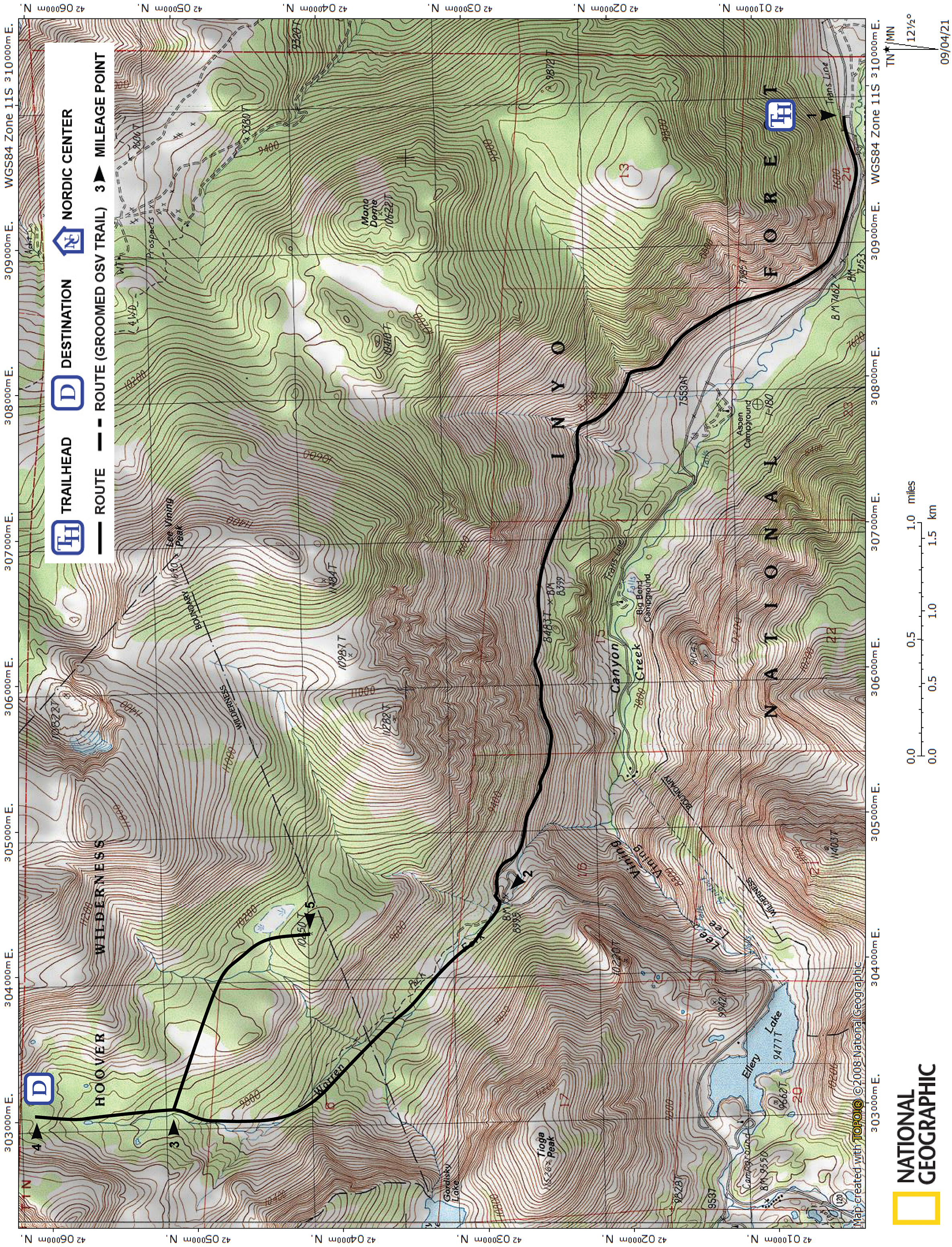
Mileage Log ![]()
Numbers in parentheses
correspond to mileage points on map
Waypoint 1 to 2
Miles: 0.0 - 4.2
Elevation change: +1600
From the trailhead (1), ski or walk and ski west on Tioga Pass Road for 4.2 miles until you reach the Warren Fork (2).
Waypoint 2 to 3
Miles: 4.2 - 6.0
Elevation change: +950
Leave the road and ski north up the canyon, paralleling the Warren Fork for 1.8 miles until you reach a location where the terrain is less steep (3). The elevation here is 10,000 feet and is the point where the extension to Peak 10250 leaves the Warren Fork.
In the first 0.7 mile the canyon climbs only slightly, and the skiing is best on the southwest (left) side of the creek. Beyond, the woods become denser, and the gradient becomes significantly steeper, but both ease off as you climb higher. About a mile from the road, you will find it advantageous to cross to the northeast (right) side of the creek, but you will probably cross back and forth a couple of times as you continue to climb.
Waypoint 3 to 4
Miles: 6.0 - 6.6
Elevation change: +250
Continue north up the canyon for 0.6 mile until you reach a bowl (4) and the end of the tour.
Return to trailhead
Miles: 6.6 - 13.2
Elevation change: -2800
Retrace the route for 6.6 miles back to the trailhead (1).
Extension to Peak 10250
Peak 10250 is a special place in the Warren Fork drainage. From the peak you are treated to excellent views up, down, and across the canyon, and is a perfect setting for lunch or a break.
Waypoint 3 to 5
Miles: 0.0 - 1.1
Elevation change: +350, -100
From waypoint 3, which is located at an elevation of 10,000 feet where the terrain along the Warren Fork is less steep, follow the route shown on the map to the southeast for 1.1 mile until you reach Peak 10250 (5).
Return to trailhead
Miles: 1.1 - 2.2
Elevation change: -350, +100
Retrace the route for 1.1 miles back to the waypoint 3.