Summary ![]()
| Difficulty | 3 Intermediate |
| Length | 14.6 miles round trip |
| Starting Elevation |
7000 feet |
| Cumulative Elevation Change |
+1700, 1700 round trip |
| Navigation | Road |
| Time | Full day |
| Season | Late December through March |
| Snowmobiles Use | Low |
| USGS Topo | 7.5' series, Bodie |
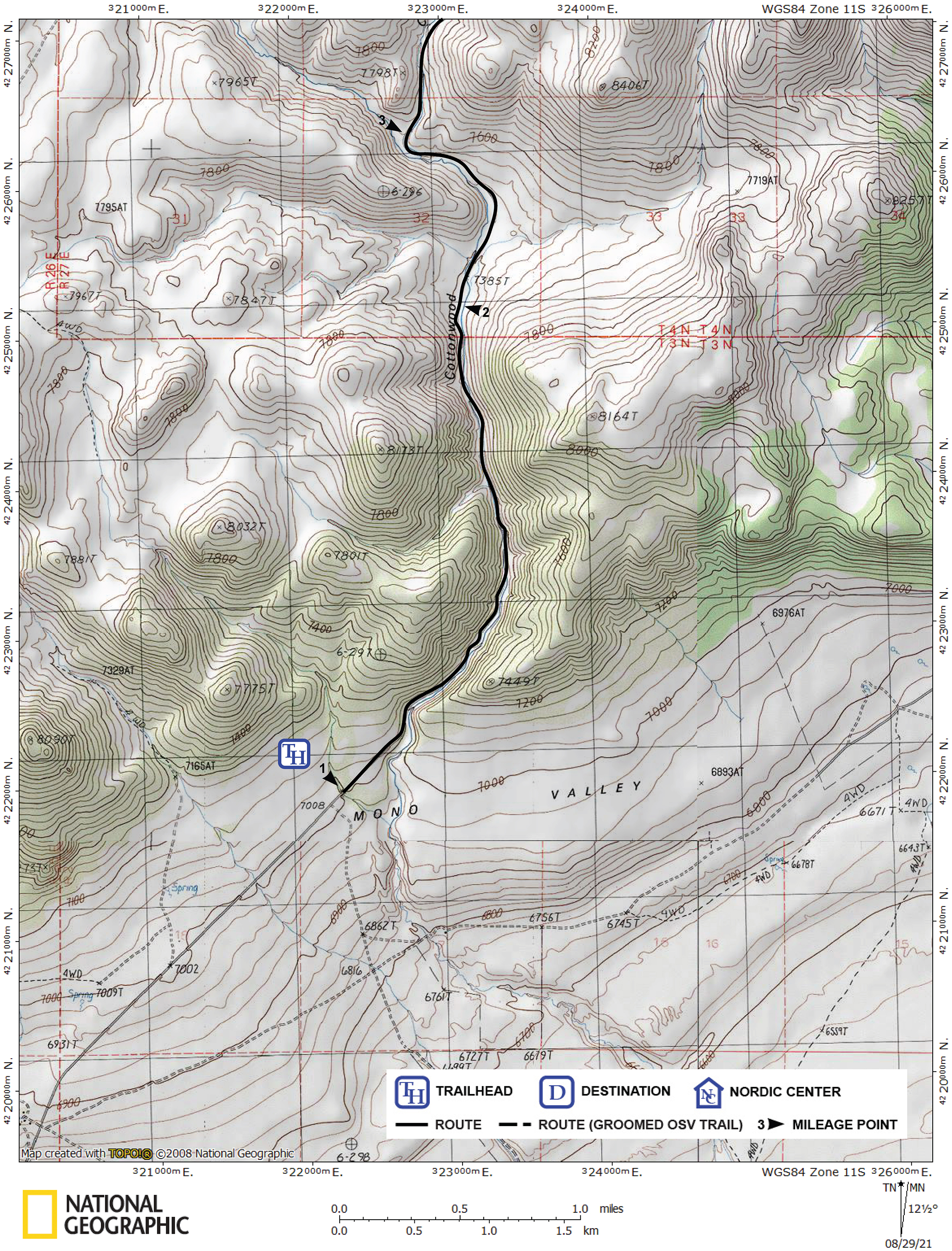
| Start | The mouth of Cottonwood Canyon. From Highway 395, drive east on Highway 167 toward Hawthorne for 7.5 miles until you reach the Bodie turnoff sign. Turn left onto the dirt road and drive 1.7 miles to a road junction, turn right and drive 0.4 mile until you pass Goat Ranch, and continue for 2.3 miles to the mouth of the Cottonwood Canyon. |
Description ![]()
In 1859 gold was discovered where the ghost town of Bodie now stands. By 1879 Bodie boasted a population of more than 10,000. Although only about five percent of the buildings remain on the quiet streets, Bodie is the best preserved ghost town in North America and is managed as a California State Historic Park.
Bodie is normally visited during the summer months when the roads are passable by car, but during the winter months cross-country skiers can explore the weathered and dilapidated buildings, now maintained in a state of "arrested decay." Photographers will find unique opportunities at this ghost town during the winter.
The route described in this tour begins in Mono Lake Basin and follows Cottonwood Canyon to Bodie Basin. This shorter route consistently has better snow conditions than the alternate route along Bodie Road, which leaves Highway 395 about seven miles south of Bridgeport.
You should be aware, however, that the starting point for the Cottonwood Canyon route varies. Sometimes you cannot even reach the mouth of the canyon, and other times you can drive part way up the canyon. Except immediately after a snowfall, there will be Sno-Cat tracks from the vehicles used by park service personnel for transportation. Where the snow begins, expect to ski along the edge of the road in order to avoid the muddy tracks.
It is recommended that you obtain a park brochure with a map of the town and buildings prior to making the journey to Bodie. It can be downloaded at: https://www.parks.ca.gov/?page_id=509. The park headquarters in Bodie is located near the old Methodist Church, but it is unlikely that you will find in staffed it winter.
Mileage Log ![]()
Numbers in parentheses
correspond to mileage points on map
Waypoint 1 to 2
Miles: 0.0 - 2.3
Elevation change: +400
From the trailhead (1), follow the road north into the canyon for 2.3 miles until the canyon temporarily widens (2). Just ahead, in the widened area, two small drainages intersect the road from the east and west.
Waypoint 2 to 3
Miles: 2.3 - 3.3
Elevation change: +150
Continue on the road for 1.0 mile until your reach the junction of two canyons (3). The route to Bodie continues on the road that follows Cottonwood Canyon, the canyon farthest east (right).
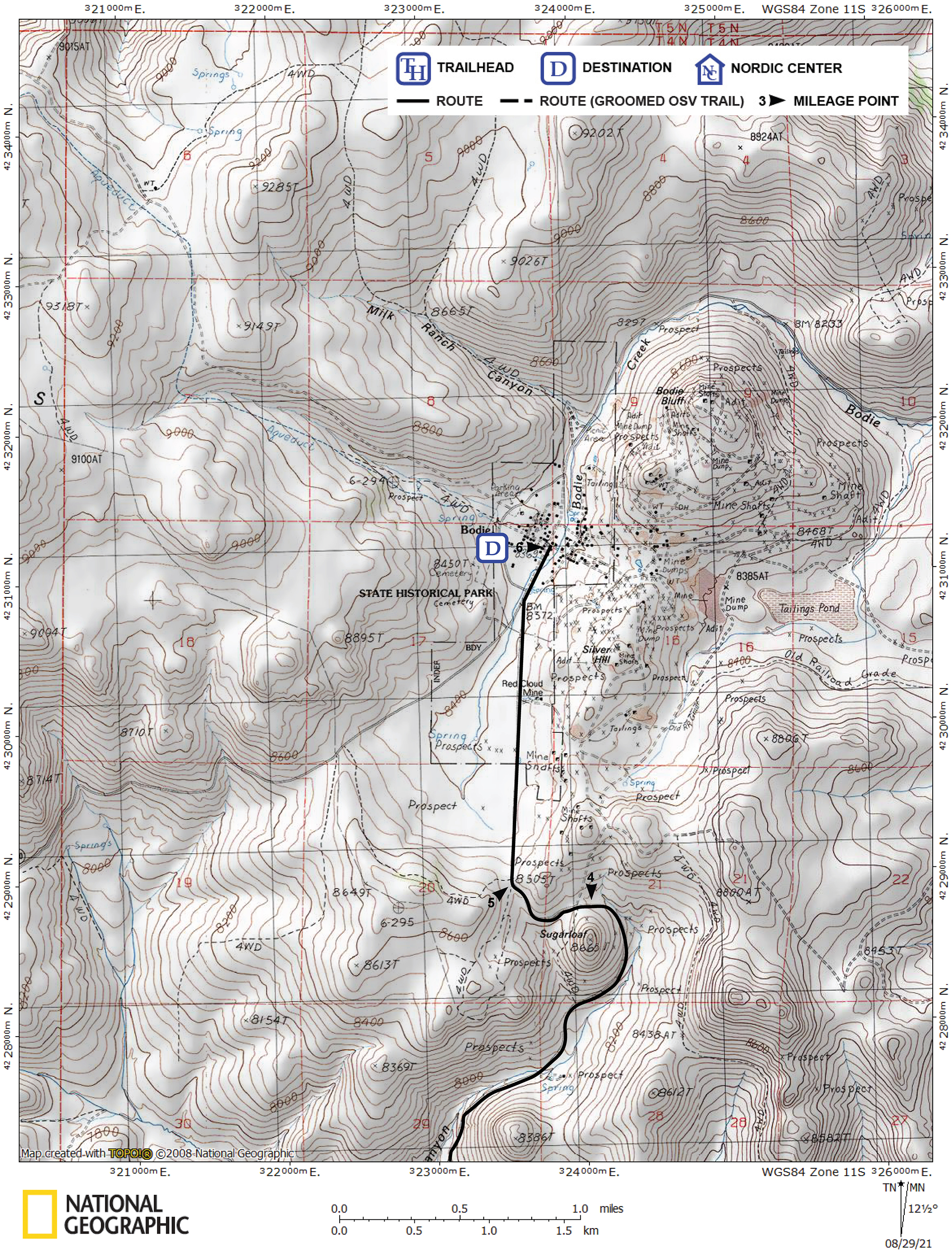
Waypoint 3 to 4
Miles: 3.3 - 5.4
Elevation change: +900
Continue on the road up Cottonwood Canyon, the canyon farthest east (right), for 2.1 miles until you reach the north side of Sugarloaf (4). Once you are on the north side of Sugarloaf, poor snow conditions should improve.
Waypoint 4 to 5
Miles: 5.4 - 5.9
Elevation change: +100
Continue on the main road for 0.5 mile until you reach the saddle (5) at the south end of Bodie Basin from which you can see the town of Bodie to the north. In the basin ahead of you there will be significantly more snow than elsewhere in the vicinity. As you ski from the north side of Sugarloaf to the saddle, you will have a view to the south of Mono Lake.
If you are planning to camp overnight in the area, be aware that camping is not permitted in the basin proper. The park service recommends camping in the aspen grove north of a small peak and west of the saddle.
Waypoint 5 to 6
Miles: 5.9 - 7.3
Elevation change: -150
Ski north for 1.4 miles until you reach the center of historic Bodie (6).
Once you arrive at Bodie, remember that hazards exist due to the condition of the buildings and open mine shafts. While you are in town, stay on the streets and sidewalks because most of the buildings are unsafe. Do not enter hazardous areas, signs are normally posted, but deep snow can cover them. In general, the area to the east of the center of town, including the mill and surrounding buildings, and Bodie Bluff, are off limits.
From the town of Bodie, you can see and climb Bodie Mountain to the northwest. Closer by there are many other hills which can afford excellent downhill practice.
Return to trailhead
Miles: 7.3 - 14.6
Elevation change: +150, -1550
Retrace the route for 7.3 miles back to the trailhead (1).