Summary ![]()
| Difficulty | 1-4 Beginner - intermediate-advanced |
| Length | Up to 22.0 miles round trip |
| Starting Elevation |
7250 feet |
| Cumulative Elevation Change |
Up to +2600, -2600 round trip |
| Navigation | Road (groomed) |
| Time | Up to very long day |
| Season | December through mid-April |
| Snowmobiles Use | Not permitted [Please report illegal use of snowmobiles in this area.] |
| USGS Topo | 7.5' series, El Capitan, Half Dome |
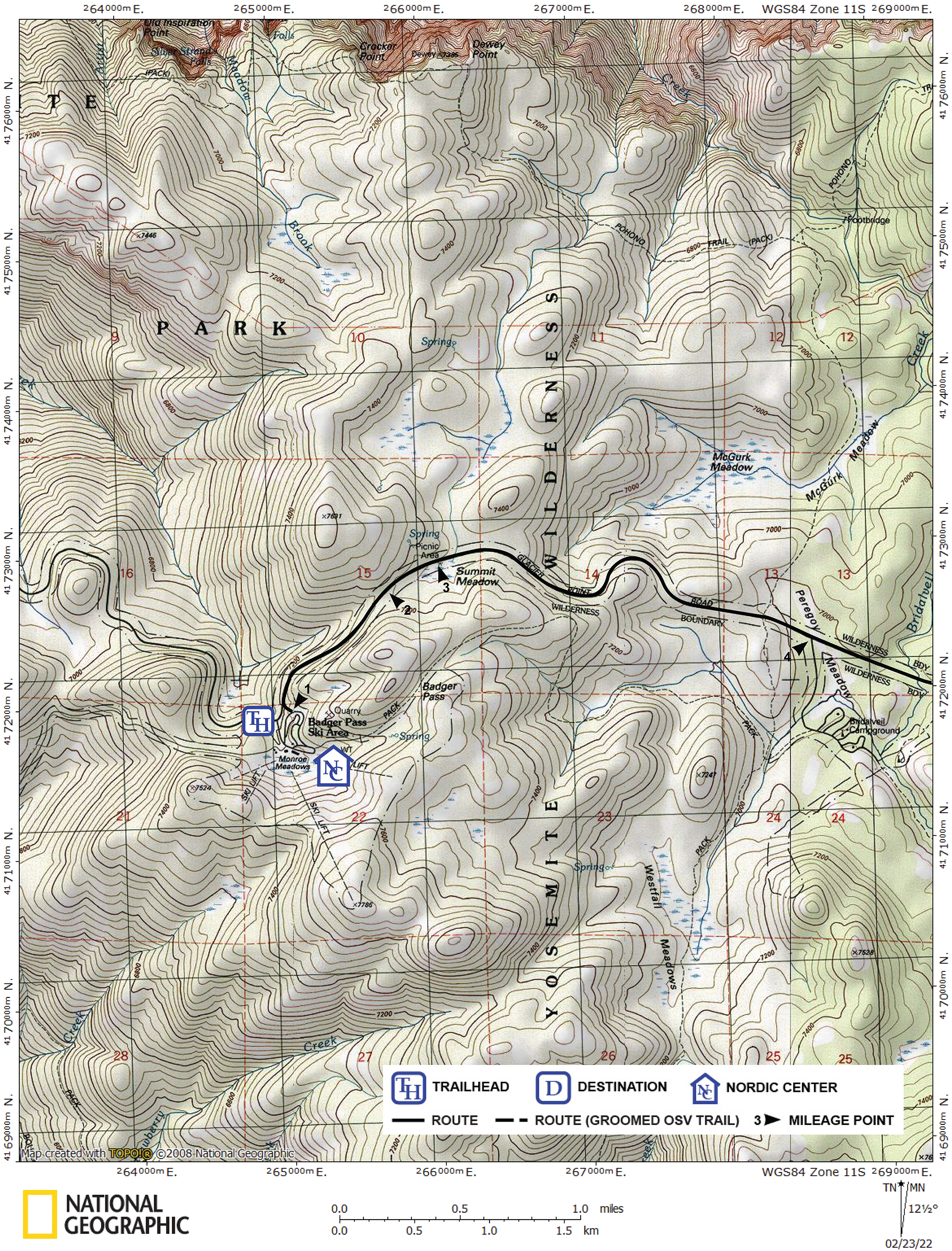
| Start | Badger Pass Ski Area on Glacier Point Road. The trailhead is located at the north end of the parking lot. |
Description ![]()
Ski the entire distance to Glacier Point to be treated to spectacular views of Yosemite Valley 3200 feet below, Half Done, Vernal and Nevada Falls, plus vistas of the impressive Clark Range. Best of all, winter is an opportunity to enjoy this beauty in peace since nearly all tourists are stopped by the snow-covered road.
There are other landmarks along Glacier Point Road that you can choose as a destination. The most significant ones are Summit Meadow at 1.0 miles and Peregoy Meadow at 2.8 miles. Glacier Point Road is also the access to other tours in the area including ever popular Dewey Point and the multi-day tour to Ostrander Lake and the hut located there.
The short distance and minimal elevation change to Summit Meadow make it an excellent choice for beginners. Once there you can spend time practicing both in the flat area and on the adjacent slopes.
In the "old days" skiers used to drive out to Summit Meadow and break trail from there along Glacier Point Road. Today the entire 11.0 miles of Glacier Point Road from Badger Pass Ski Area to the point are groomed making it significantly easier to make the round trip in a single day.
Others choose to make the tour to Glacier Point into an overnight trip by snow-camping at the point. You must obtain a permit at the Badger Pass Ski Area ranger station if you choose to do this.
Another alternative is spending the night at Glacier Point in the comfort of the Glacier Point Backcountry Ski Hut.
Mileage Log ![]()
Numbers in parentheses
correspond to mileage points on map
Waypoint 1 to 2
Miles: 0.0 - 0.7
Elevation change: +150, -50 feet
From the trailhead (1) ski northeast on the groomed trail and Glacier Point Road for 0.7 mile until you reach a high point (2). The first 50 yards is not actually on the road, but you will probably not notice the transition from the connecting trail to the road.
Waypoint 2 to 3
Miles: 0.7 - 1.0
Elevation change: -50 feet
Continue skiing on Glacier Point Road for 0.3 mile until you reach Summit Meadow (3) and the turnoff to the Meadow Trail to Dewey Point at the east end of the meadow. The short distance and minimal elevation change make the tour to Summit Meadow an excellent choice for beginners.
Waypoint 3 to 4
Miles: 1.0 - 2.8
Elevation change: -350 feet
Continue skiing on Glacier Point Road for 1.8 miles until you reach Peregoy Meadow, and the turnoff to Bridalveil Campground (closed in winter) and the Ghost Forest Trail (4).
Waypoint 4 to 5
Miles: 2.8 - 4.1
Elevation change: +150, -150 feet
Continue skiing on Glacier Point Road for 1.3 miles until you reach Bridalveil Creek Trail (5). The turnoff for Bridalveil Creek Trail is marked with a sign, goes to Ostrander Lake, and the is designated as trail number 21.
Waypoint 5 to 6
Miles: 4.1 - 4.5
Elevation change: +50 feet
Continue skiing on Glacier Point Road for 0.4 mile until you reach Horizon Ridge Trail (6). The turnoff for Horizon Ridge Trail is marked with a sign, goes to Ostrander Lake, and the trail is designated as trail number 15.
Waypoint 6 to 7
Miles: 4.5 - 9.2
Elevation change: +900, -150 feet
Continue skiing on Glacier Point Road, which shortly turns north, for a total of 4.7 miles until you reach the turnoff to Sentinel Dome (7). In this section you will pass Pothole Meadows. If time permits, you can ascend Sentinel Dome as a side trip, which adds 1.2 miles and +300/-300 feet of elevation change.
Waypoint 7 to 8
Miles: 9.2 - 11.0
Elevation change: -600 feet
Continue skiing on Glacier Point Road, descending steeply, for 1.8 miles until you reach Glacier Point (8). This last section is the most difficult of the entire tour. The actual road and groomed trail stops a short distance before the overlook.
Return to trailhead
Miles: 11.0 - 22.0
Elevation change: +1350, -1250 feet
Retrace the route for 11.0 miles back to the trailhead (1).