
Summary ![]()
| Difficulty | 4 Intermediate-advanced |
| Length | 6.2 miles round trip |
| Starting Elevation |
7550 feet |
| Cumulative Elevation Change |
+1600, -1600 feet round trip |
| Navigation | Road and map |
| Time | Full day |
| Season | December through mid-April |
| Snowmobiles Use | Not permitted [Please report illegal use of snowmobiles in this area.] |
| USGS Topo | 7.5' series, Tamarack, Mokelumne Peak |
| Start | Round Valley Sno-Park, 0.2 mile north of Highway 4 on Highway 207 (the road to Bear Valley Mountain Resort). |
Description ![]()
The tour to Mount Reba from Poison Canyon is a step up in terms of commitment from the Round Valley from Poison Canyon tour, but you are well rewarded for your effort. You get all the benefits of the shorter tour, excellent touring terrain, fantastic opportunities for linking turns, panoramic vistas to the south of the red cliffs of the Dardanelles and beyond, and is located in an area closed to snowmobile use, plus you are treated to amazing scenery from a high ridge that leads to Mount Reba and the peak itself.
But beware, the ridge and peak are nowhere to be in foul weather. They are completely exposed to weather approaching from any direction and without good visibility there is little reason to visit here given that the scenery is the main attraction.
 Looking back at the cornices along the ridge that leads to Mount Reba
 Salt Springs Reservoir from Mount Reba.
 Mileage Log ![]()
Numbers in parentheses
correspond to mileage points on map
Waypoint 1 to 2
Miles: 0.0 - 0.1
Elevation change: +100 feet
From the trailhead (1) at the Sno-Park, ski northeast on the snow-covered road for 0.1 mile until you reach a location where you can turn and head north (left) (2).
Waypoint 2 to 3
Miles: 0.1 - 0.6
Elevation change: +350 feet
Climb north, zigzagging as required, for 0.5 mile until you reach a ridge (3). You will pass through trees as you approach the ridge.
Waypoint 3 to 4
Miles: 0.6 - 1.4
Elevation change: +550 feet
Climb to the northeast along the ridge for 0.3 mile and then northeast across an open slope for 0.5 mile until you reach the Peak 8605 (4).
 Red banded cliffs of the Dardanelles and beyond
 Approaching Peak 8605
Waypoint 4 to 5
Miles: 1.4 - 1.7
Elevation change: -100 feet
Descend slightly east of north for 0.3 mile through trees until you reach a saddle (5). Along this section, look for a view of the ridge leading to Mount Reba and Round Valley below.
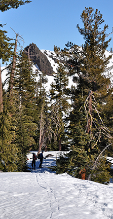 Descending from Peak 8605 to the saddle
 Ridge leading to Mount Reba with Round Valley below
Waypoint 5 to 6
Miles: 1.7 - 3.1
Elevation change: +400, -100 feet
Ascend northwest and then ski on or near the ridge for a total of 1.4 miles until you reach Mount Reba (6). You will pass to the south of the Reba Peak, which at 8842 feet is a bit higher than Mount Reba. But Mount Reba commands a superior view.
 Ridge leading to Mount Reba
 Volcanic cliffs to the north of ridge leading to Mount Reba
 Skiers take route below ridge on return from Mount Reba
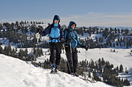 Round Valley below and Poison Peak in background
Return to trailhead
Miles: 3.1 - 6.2
Elevation change: +200, -1400 feet
Retrace the route for 3.1 miles back to the trailhead (1).
