Summary ![]()
| Difficulty | 4 Intermediate-advanced |
| Length | 10.5 miles one-way |
| Starting Elevation |
7950 feet |
| Cumulative Elevation Change |
+1250, -2500 feet round trip |
| Navigation | Road, map and compass |
| Time | Full day |
| Season | December through mid-April |
| Snowmobiles Use | Moderate |
| USGS Topo | 7.5' series, Calaveras Dome, Tamarack |
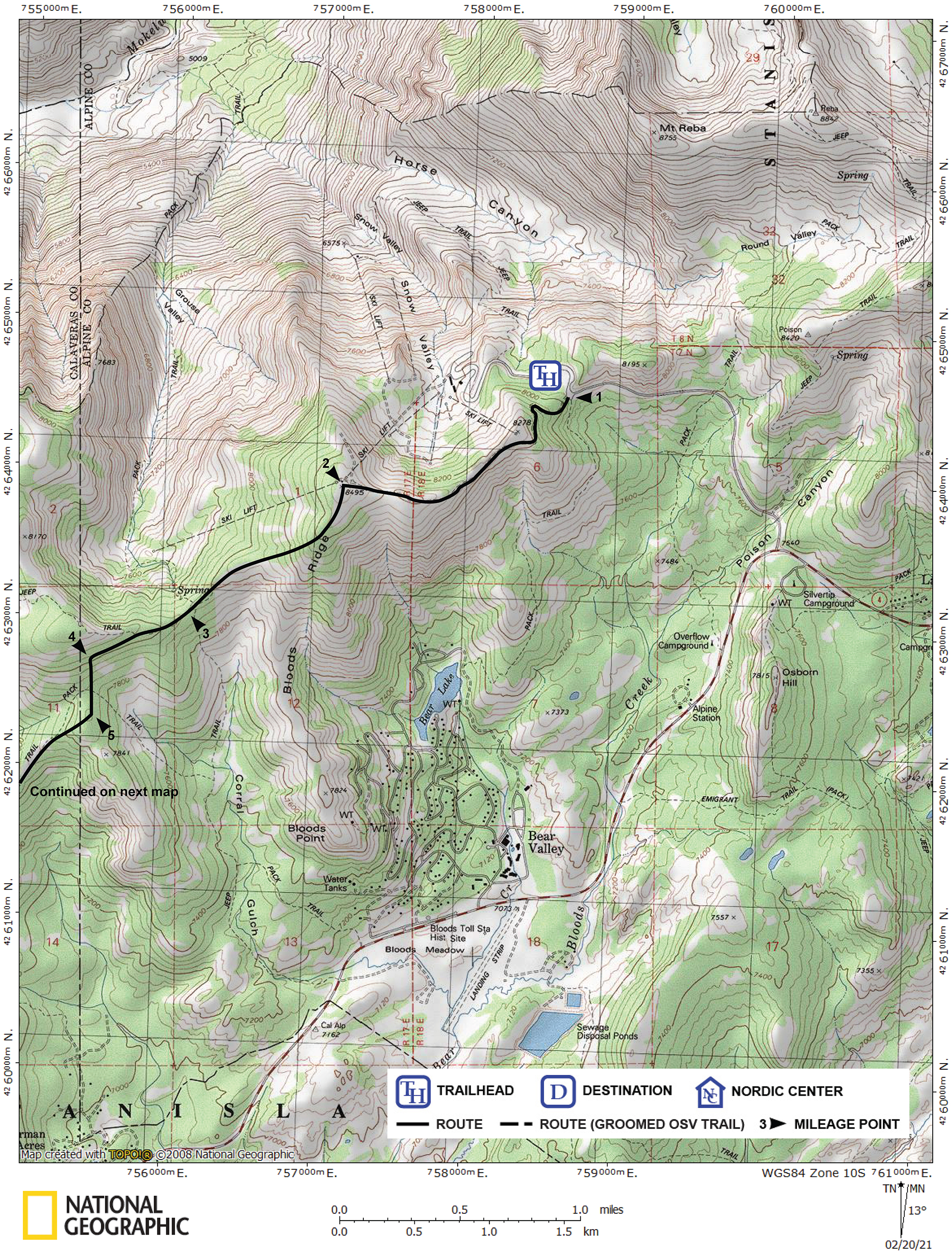
| Start | The maintenance station at Bear Valley Mountain Resort. Park as close as possible to the high point of Highway 207 near the maintenance station. |
Description ![]()
If there is a classic tour in the Bear Valley area it is this one-way ski along the high ridges. Of the tour's 10.5 miles, almost eight of those miles are along ridges. Pretty awesome!
This tour was named back when the ski area at Bear Valley was called Mount Reba, not because the tour began at or even went to Mount Reba though it is nearby. Today the ski area is called Bear Valley Mountain Resort.
Although some of the route is in trees, most is through sparsely wooded and wide open terrain, and thus the views are spectacular. To fully enjoy this tour and for safety you should save it for a fair weather day.
Another selling point of this tour is the net elevation loss of 1250 feet with a total of 2500 feet of downhill along the route. On the downside, snowmobiles access the ridges from Bear Valley and housing developments along the highway. Hopefully you will visit on a day when there are few if any; consider doing this tour mid-week.
Mileage Log ![]()
Numbers in parentheses
correspond to mileage points on map
Waypoint 1 to 2
Miles: 0.0 - 1.3
Elevation change: +600, -50 feet
From the trailhead (1) at the maintenance station follow the snow-covered road for 1.3 miles until you reach Peak 8495 (2). The summit is easy to recognize with its chair lifts, buildings and many downhill skiers.
You will encounter a road junction shortly after leaving the maintenance station; make a sharp turn to the south (left) here. Also be aware that this road is used by downhill skiers so it is best to ski along the edge of it.
At the summit you need to locate the Bear Boogie ski run.
Waypoint 2 to 3
Miles: 1.3 - 2.2
Elevation change: -550 feet
Descend gradually on the Bear Boogie ski run to the southwest and leave it and continue southwest on the ridge when the ski run turns northwest and starts to drop steeply for a total of 0.9 mile until you reach a saddle above Grouse Valley (3).
Warning: Do not confuse the ridge on which this saddle is located with Bloods Ridge that is located to the south.
Waypoint 3 to 4
Miles: 2.2 - 2.6
Elevation change: +100 feet
Gradually climb the ridge to the southwest but begin to traverse the slope after climbing only 100 feet and continue traversing for a total of 0.4 mile until you are south of a broad high point (4).
Waypoint 4 to 5
Miles: 2.6 - 2.9
Elevation change: -150 feet
Descend south toward a broad ridge for 0.3 mile until you reach a very minor high point (5).
Waypoint 5 to 6
Miles: 2.9 - 3.8
Elevation change: -300 feet
Ski southwest down and then along a ridge for a total of 0.9 mile until you reach a saddle above Bear Trap Basin (6). This section takes you out of the trees and the skiing becomes delightful along more open ridges.
Waypoint 6 to 7
Miles: 3.8 - 4.7
Elevation change: +250 feet
Ascend west and then southwest on the ridge for a total of 0.9 mile until you reach the intersection of three ridges with a clearing extending to the south (7). You have now intersected the Ridge Loop tour that ascends up the ridge through the clearing to the south. The tour you are on continues on the ridge to the west toward Peak 7873 that is 0.2 mile away.
Waypoint 7 to 8
Miles: 4.7 - 5.5
Elevation change: +100, -100 feet
Ski west toward Peak 7873, pass to its south and continue along the ridge for a total of 0.8 mile until you are on the south side of Flagpole Point (8). The tour does not ascend to the top of the Point.
Waypoint 8 to 9
Miles: 5.5 - 6.8
Elevation change: +200, -50 feet
Head southwest along a ridge for 1.3 miles until you reach the high point on Mattley Ridge (9). The climb to the high point is through dense trees.
Waypoint 9 to 10
Miles: 6.8 - 8.1
Elevation change: -650 feet
Ski south through some trees and then south along the ridge at first through a clearing but through trees as you get lower for a total of 1.3 miles until you reach Mattley Road (10). Near the top, just after entering the clearing, you will encounter a snow survey station.
Waypoint 10 to 11
Miles: 8.1 - 9.0
Elevation change: -300 feet
Turn west (right) onto Mattley Road and follow it generally southwest for a total of 0.9 mile until you reach Cabbage Patch Road (11).
Waypoint 11 to 12
Miles: 9.0 - 9.6
Elevation change: -150 feet
Turn southeast (left) onto Cabbage Patch Road and follow it for 0.6 mile until you reach a road junction (12). To the northeast (left) is Thompson Meadow. This tour continues to the southwest (right). Be aware that you will pass a road on your right 0.2 mile before reaching the junction.
Waypoint 12 to 13
Miles: 9.6 - 10.0
Elevation change: -50 feet
Turn southwest (right) and follow the road for 0.4 mile until you reach a road junction (13). The road to the west (right) goes to Blue Creek Point. This tour continues to the southwest (straight).
Waypoint 13 to 14
Miles: 10.0 - 10.5
Elevation change: -100 feet
Continue southwest for 0.5 mile until you reach the end point at Cabbage Patch (14).