Summary ![]()
| Difficulty | 5 Advanced |
| Length | 10.7 miles one-way |
| Starting Elevation |
8550 feet |
| Cumulative Elevation Change |
+1450, -2650 feet |
| Navigation | Map and compass |
| Time | Full day |
| Season | Mid-December through mid-April |
| Snowmobiles Use | Not permitted from mileage point 1 to almost 6, and from near mileage point 10 to 12. Low elsewhere. [Please report illegal use of snowmobiles in this area.] |
| USGS Topo | 7.5' series, Carson Pass, Caples Lake and Echo Lake |
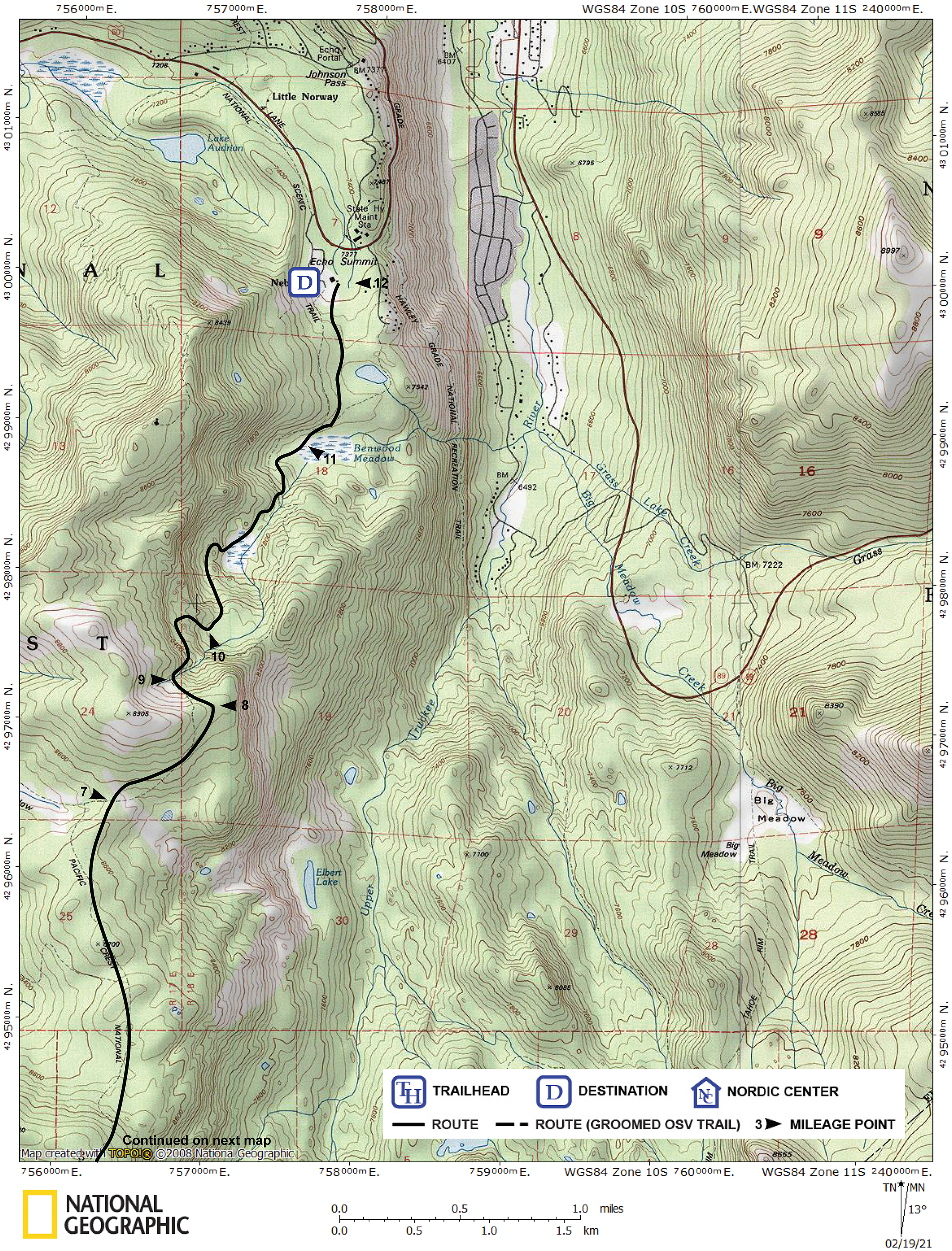
| Start | Meiss Sno-Park, 0.1 mile west of Carson Pass on Highway 88. |
| End | Adventure Mountain located on the south side of Highway 50, 0.2 mile west of the Echo Summit Maintenance Station. This is the site of the now defunct Echo Summit SnoPark. A fee is charged to park here. |
Description ![]()
This classic tour between Carson and Echo passes is both very challenging and very rewarding. The high elevation and excellent terrain will provide you with the opportunity to enjoy beautiful panoramas almost the entire distance.
The length of the tour combined with the need for extensive navigation requires that you are a very strong skier with excellent navigation skills. This tour is best left to the spring when the days are longer and the snow (hopefully) more consolidated.
The first half of this tour is identical to the first half of the Carson Pass to Caples Lake Via Showers Lake tour.
This is a variation of the Echo-to-Kirkwood Race and Tour that was sponsored by the El Dorado Nordic Ski Patrol up until 2007. Advantages of the route described in this tour, Carson Pass to Echo Summit, include a net elevation loss of 1200 feet and avoids the groomed Nordic trails at Kirkwood.
Mileage Log ![]()
Numbers in parentheses
correspond to mileage points on map
Waypoint 1 to 2
Miles: 0.0 - 1.0
Elevation change: +300, -50 feet
From the Meiss Sno-Park (1) work your way west for 0.5 mile while climbing gradually and then ascend northwest for another 0.5 mile until you reach the obvious broad saddle (2). Early and late in the snow season you may find the south-facing slopes leading to the saddle partially barren. Also, take care to avoid the slopes beneath the southwest ridge of Red Lake Peak, which may be avalanche prone.
Waypoint 2 to 3
Miles: 1.0 - 2.4
Elevation change: -400 feet
Descend north down the gully for 1.4 miles until you reach two old buildings (3) that were once operated as a ski hut. You loose nearly all the elevation in the first half of the distance. You will probably find the skiing easiest on the side-slope east (right) of the creek. Once down in the meadow-like terrain you will want to stay on the east (right) side of the creek.
Waypoint 3 to 4
Miles: 2.4 - 3.9
Elevation change: +100, -100 feet
Continue in a generally northwest direction until the meadow opens up and then continue northwest for a total of 1.5 miles until you reach a location (there is no landmark here) from which you can ascend to the northwest to Showers Lake (4).
Waypoint 4 to 5
Miles: 3.9 - 4.4
Elevation change: +350, -50 feet
Ascend northwest for 0.5 mile until you reach Showers Lake (5). This section passes through avalanche terrain.
Waypoint 5 to 6
Miles: 4.4 - 5.7
Elevation change: +350, -50 feet
Ski in a generally northwest direction on a bench for 1.3 miles until you reach the north end of the ridge of which Little Round Top is a part (6). To the west (left) of the bench is a steep ridge and potential avalanche danger, and to the east (right) is a steep drop-off.
Waypoint 6 to 7
Miles: 5.7 - 7.4
Elevation change: +150, -550 feet
Ski north for 1.7 miles until you reach a broad, flat saddle (7) to the east of Bryan Meadow and south of Peak 8905. Ski east to the saddle if you find yourself in the Bryan Meadow.
Waypoint 7 to 8
Miles: 7.4 - 8.2
Elevation change: +150 feet
Climb gradually northeast for 0.8 mile until you reach a flat area on the east spur of Peak 8905 (8).
Waypoint 8 to 9
Miles: 8.2 - 8.4
Elevation change: -200 feet
Descend northwest for 0.2 mile until you find yourself at the top of a steep gully (9).
Waypoint 9 to 10
Miles: 8.4 - 8.9
Elevation change: -450 feet
Descend the gully carefully to the northeast, then ski north before looping around to the southeast for a total of 0.5 mile until you reach level terrain (10). Be aware that this gully is a potential avalanche chute. If the gully is icy you may find it easier to walk down. You may also find it easier and safer to descend through the trees alongside the gully.
You should pick up blue diamond trail markers somewhere between here and the end of the tour.
Waypoint 10 to 11
Miles: 8.9 - 10.0
Elevation change: -650 feet
Descend north and then northeast down the drainage, passing through a small meadow, for a total of 1.1 miles until you reach Benwood Meadow (11).
Waypoint 11 to 12
Miles: 10.0 - 10.7
Elevation change: +50, -150 feet
Continue north for 0.7 mile until you reach the parking area at Adventure Mountain (12).