
Summary ![]()
| Difficulty | 4 Intermediate-advanced |
| Length | 7.0 miles one-way or 6.0 miles one-way to alternate end point |
| Starting Elevation |
7950 feet |
| Cumulative Elevation Change |
+850, -1550 feet or +1150, -1550 feet to alternate end point |
| Navigation | Road, map and compass |
| Time | Full day |
| Season | Mid-December through mid-April |
| Snowmobiles Use | Moderate use for the first 1.1 miles with low use for the remainder of the tour. The Silver Bear Snowmobile Trail used to coincide with the first part of this tour but has not been groomed for many years. |
| USGS Topo | 7.5' series, Tragedy Spring, Caples Lake, Bear River Reservoir and Mokelumne Peak |
| Start | On the south side of Highway 88 at Tragedy Spring, 9.0 miles east of Peddler Hill Maintenance Station and 2.9 miles west of the Silver Lake dam. You may find the snow bank at the starting point too high and steep to climb. In this case walk along the highway to find a better spot, but be cautious of vehicle traffic. |
| End | Kaye's Resort on Highway 88 at the west end of the Silver Lake dam. Park in the plowed area at the east end of the dam. It is a very short walk from Kaye's Resort to the parking. The resort was closed in 2006 and remains closed.
Alternate end is a pullout on the south side of Highway 88, 1.1 miles northeast of Tragedy Spring. |
Description ![]()
Like the Tragedy Spring to Silver Lake Via Porthole Gap tour, this tour via the summer hiking trail drops from a ridge down to Silver Lake and ends with a ski along the lake's entire two-mile length. But there are significant differences that make the two tours entirely different, the least of which is the longer length.

On summit of Plasse
The navigation necessary to find the point where the summer trail drops off the ridge is much more difficult making this a definite intermediate-advanced tour. It is also an intermediate-advanced tour because the skiing in the drainage, after leaving the ridge, is of solid intermediate-advanced difficulty. Dropping off the ridge is steep and the drainage is chuck full of trees and boulders that force you to make tight turns.
Navigation in the drainage is not difficult from the standpoint that if you head downhill you will eventually reach Silver Lake. However, picking a "direct" route through the trees and boulders takes considerable care and use of a compass. This is more difficult when the snow cover is poor.
The ski across Silver Lake often offers ideal conditions for kicking and gliding or skating as you traverse its length. While this part of the tour will drive you to wanting a light pair of skis and boots, the upper parts of the tour certainly warrant heavier equipment that provide more control.
The bleakness of snow-covered Silver Lake, hemmed in by mountains, is certainly a wonderful setting and worth the ski. But you may want to consider the alternate end point for this tour, which saves you 0.9 mile by ascending a road from Plasse Resort to Highway 88 at BM 7588. This alternative, which is described in the mileage log, adds 300 feet of elevation gain.
Mileage Log ![]()
Numbers in parentheses
correspond to mileage points on map
Waypoint 1 to 2
Miles: 0.0 - 0.6
Elevation change: +200 feet
From the trailhead (1) ski south on a snow-covered road for 0.6 mile until you reach the west side of the Peak 8180 (2). It may not be possible to discern the road in which case you must find your own route.
Waypoint 2 to 3
Miles: 0.6 - 1.2
Elevation change: -250 feet
Descend southeast for 0.6 mile until you reach a saddle (3) near Porthole Gap.
Waypoint 3 to 4
Miles: 1.2 - 2.0
Elevation change: +550 feet
Ascend southeast for 0.8 mile until you reach Plasse (4) — the peak.
Waypoint 4 to 5
Miles: 2.0 - 3.0
Elevation change: -350 feet
Ski southeast and then generally west for a total of 1.0 mile until you reach the buildings at Allen (5). The relatively level first 0.3 mile, before you round the south side of a knob, is pretty straight forward. The descent beyond to Allen is in and out of trees and requires careful navigation using a compass; do not expect to find the snow-covered road.

On route between Plasse and Allen
The big challenge is actually finding Allen because it sits in a nondescript location in a very large flat area. The building at Allen sits at the north end of a meadow.
While the building at Allen is an excellent landmark, it is not necessary to actually go to it. Once in the flat area you can just head north until you reach the saddle on the ridge.
Waypoint 5 to 6
Miles: 3.0 - 3.3
Elevation change: +100 feet
Ski north, climbing gradually, until you reach the saddle on the ridge (6). At the saddle you must locate the best place to descend off the ridge. Be careful to avoid any cornices.

Saddle from which you descend
Waypoint 6 to 8
Miles: 3.3 - 5.2
Elevation change: -950 feet
Descend north and then northwest down the drainage for 1.9 miles until you reach Silver Lake (8). The first 200 feet of the descent are very steep; then the slope lessens. You may recognize the high point labeled 7745 on the map, but most of the time you will be "flying blind" in terms of where you are unless you are using a GPS (if it works in the tree-filled drainage). Regardless of the route you take, the drainage will lead you to Silver Lake.
As you approach Plasse Resort and Silver Lake you will probably find yourself between the two forks that form the creek that flows into the lake. Whether one or both of the creeks form obstacles will depend on the snow-cover. There is a bridge across the combined creek that flows into the lake. It is located a short distance north of the confluence of the two creeks.
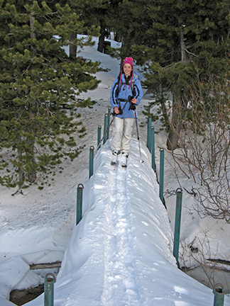
Bridge across creek near Plasse Resort and Silver Lake
Waypoint 8 to 9
Miles: 5.2 - 7.0
Elevation change: Nil
Ski north along the west shore of Silver Lake for 1.8 miles until you reach the site of Kaye's Resort (9). Under no circumstances should you attempt to cross the outlet of the lake near the dam to reach the parking area at the east end of the dam; carefully walk there along the highway.
Alternate Route
The alternate route, which ends on Highway 88 at BM 7588, takes off from the main route at mile 5.1. Here, just before reaching Silver Lake and midst the buildings of Plasse Resort (7), you must locate the snow-covered road that ascends to the highway.
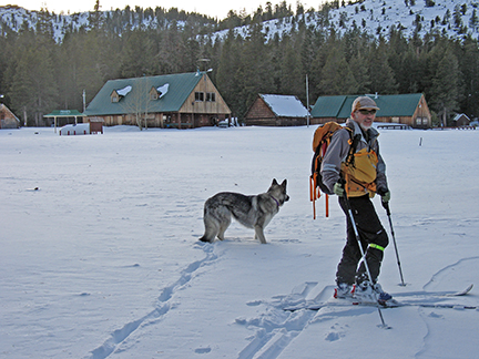
Plasse Resort
Waypoint 7 to 10
Miles: 5.1 - 6.0
Elevation change: +300 feet
Ascend the snow-covered road, at first west and then north for 0.9 mile until you reach Highway 88 (10).
