
Summary ![]()
| Difficulty | 4 Intermediate-advanced |
| Length | 4.4 miles round trip or 4.7 miles round trip via alternate return route |
| Starting Elevation |
7850 feet |
| Cumulative Elevation Change |
+1350, -1350 feet or +1550, -1550 feet via alternate return route |
| Navigation | Map and compass |
| Time | Most of a day |
| Season | Mid-December through April |
| Snowmobiles Use | Not permitted [Please report illegal use of snowmobiles in this area.] |
| USGS Topo | 7.5' series, Caples Lake |
| Start | South side of Highway 88 at the summer trailhead for Thunder Mountain, 0.2 miles east of an eastbound passing lane and 0.3 mile west of the Carson Spur. Parking is in a small plowed area. Alternative parking on south side of Highway 88 along the eastbound passing lane in small cuts made by CalTrans. The passing lane is located between 0.5 and 1.2 miles west of the Carson Spur. Special notice. |
Description ![]()
The tour to Martin Point has so many pluses that it is hard to decide where to begin. The terrain, the snow and the vistas are all worth the trek for themselves. The fact that this area gets little use makes the area even more attractive.
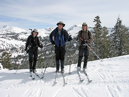
High above Kirkwood Ski Resort on route to Martin Point
The climb to Martin Point is downright steep in a few places. But the steep sections are short and most of the tour to the summit is a continuous, moderate climb. The length, steepness and relatively straightforward navigation make this tour a candidate for strong intermediate skiers who have not before experienced the pleasure of reaching a summit on skis.

Route on ridge to Martin Point
Skiers proficient in the telemark turn and who enjoy powder skiing through trees, dense at times, will want to choose the alternate return route that follows the east-west drainage that lies to the north of Martin Point. This route ekes out the last foot of elevation drop before heading back to the highway. Depending on the temperature, in the drainage the powder lasts for a week or more due to protection from the sun by the ridge to the south and the trees.
A word of caution. A compass and the knowledge of how to determine general directions are advisable if you plan on leaving the ridge and skiing through the trees on the return.

Looking west from Martin Point
And don't forget the scenery that is gorgeous both along the ascent and from the summit. To the north is Desolation Wilderness and Pyramid Peak, to the southwest and below is Silver Lake, and parts of the Mokelumne Wilderness are visible to the south and east. On a clear day you can see the coastal ranges and Mt. Diablo. Also along the route you will get a close-up look at the “jet roofs” that help protect the Carson Spur from avalanches.
The jet roofs along the ridge of which Carson Spur is a part are designed to accelerate the wind and blow snow off the ridge thereby preventing the build-up of a cornice that would eventually avalanche onto the highway below. GAZ-EX avalanche control cannons are located on the slope that descends to the highway and are used to clear the slopes of potential avalanche. Stay on the south side of the jet roofs; never travel on the north side.
Finally, don't be surprised to find SnoCat tracks in some places. Some will be from the crews that service the jet roofs and other avalanche control equipment. As you approach Martin Point you may encounter SnoCat tracks from Kirkwood Ski Resort, which has a permit for guided SnoCat skiing in the area.
The Two Sentinels at 1.3 miles from the starting point makes an excellent alternative tour and eliminates the steepest parts of the Martin Point tour.
Mileage Log ![]()
Numbers in parentheses
correspond to mileage points on map
This mileage log begins at the summer trailhead for Thunder Mountain. Adjustments to the described route are required if parking at the alternative location.
Waypoint 1 to 2
Miles: 0.0 - 0.7
Elevation change: +400 feet
From the trailhead (1) ski east for 0.7 mile, at first gradually and then more steeply, until you reach the ridgetop (2) adjacent to Carson Spur.
Waypoint 2 to 3
Miles: 0.7 - 1.3
Elevation change: +400 feet
Ski southeast for 0.6 mile until you reach the first of the Two Sentinels (3).
Waypoint 3 to 5
Miles: 1.3 - 1.5
Elevation change: +50 feet
Ski southeast and then south for a total of 0.2 mile, passing the second of the Two Sentinels, until you reach the north side of the last rock outcrop (5).
Waypoint 5 to 6
Miles: 1.5 - 1.8
Elevation change: +50 feet
Ski south around the west (right) side of the rock outcrop and then back onto the ridge for a total of 0.3 mile until you reach the saddle just to the south of the outcrop (6).
Waypoint 6 to 7
Miles: 1.8 - 2.2
Elevation change: +450 feet
Ski south up the ridge and then west for a total of 0.4 mile until you reach the summit of Martin Point (7).
Return to trailhead
Miles: 2.2 - 4.4
Elevation change: -1350 feet
Retrace the route for 2.2 miles back to the trailhead (1) or follow the alternative route described below.
Alternate Return Route
The following is an alternate return route. It adds 0.3 mile and +200, -200 feet of elevation change. Navigation and skiing are more difficult due to dense trees.
Waypoint 7 to 4
Miles: 2.2 - 3.0
Elevation change: -550 feet
Retrace your tracks for 0.8 mile until you reach a point just to the south of the south-most of the Two Sentinels (4). This is where the alternate route leaves the ridge. Expert skiers can leave the ridge earlier including from the summit of Martin Point.
Waypoint 4 to 8
Miles: 3.0 - 4.3
Elevation change: -1000 feet
Descend west through the trees for 1.3 miles until the terrain becomes flat (8). The trees in this section are dense in places. Ski north and away from the creek when necessary to find more open terrain.
Waypoint 8 to 1
Miles: 4.3 - 4.7
Elevation change: +200 feet
Ski north north for 0.4 mile until you reach Highway 88 and the trailhead (1).
