Summary ![]()
| Difficulty | 4 Intermediate-advanced |
| Length | 5.0 miles round trip |
| Starting Elevation |
7250 feet |
| Cumulative Elevation Change |
+1200, -1200 feet |
| Navigation | Map and compass |
| Time | Full day |
| Season | Mid-December through mid-April |
| Snowmobiles Use | Low |
| USGS Topo | 7.5' series, Echo Peak, Freel Peak, Caples Lake |
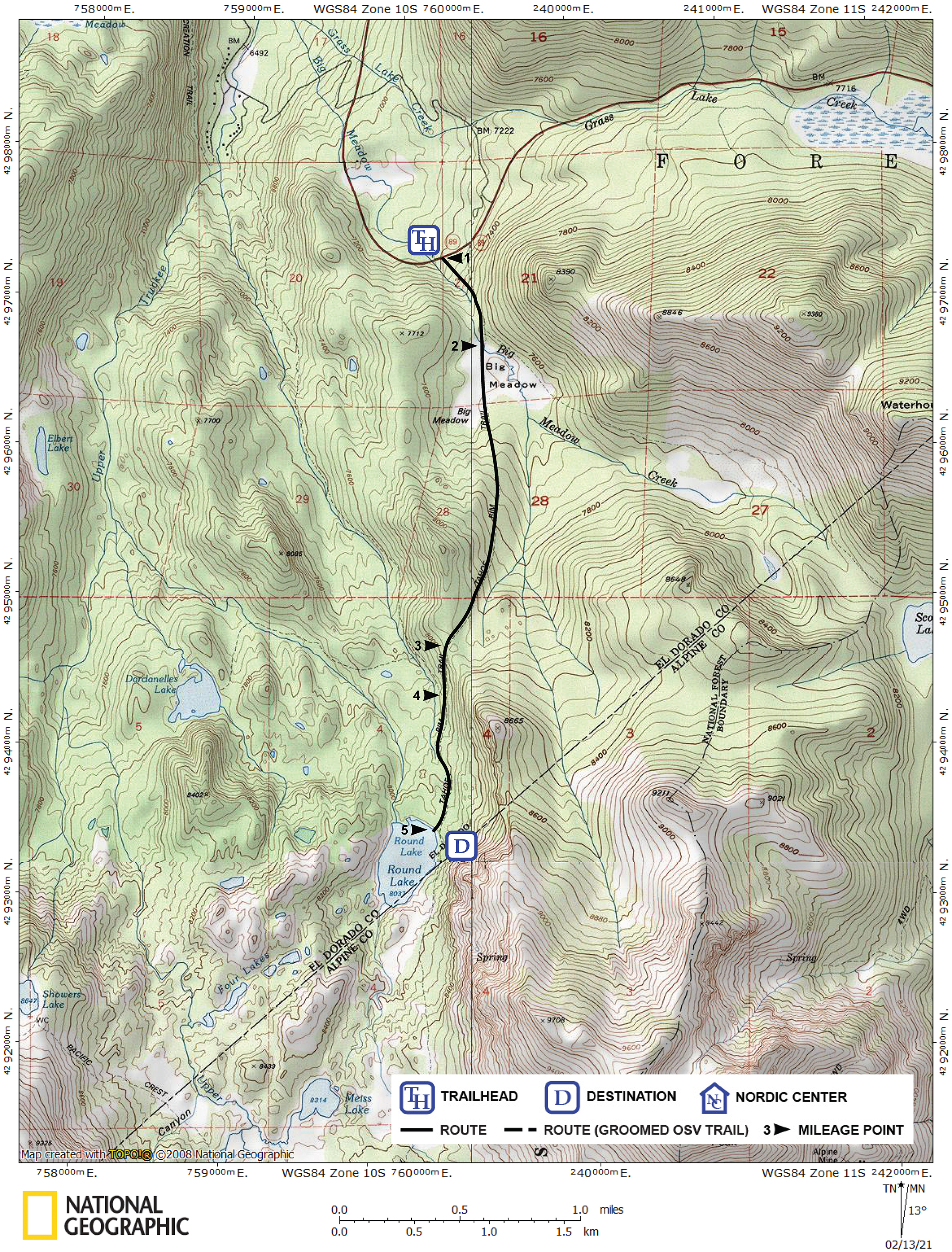
| Start | Highway 89, 5.0 miles south of Meyers. There is a turnout on the north side of the road. |
Description ![]()
After leaving Big Meadow behind, it is unlikely that you will meet other skiers on this tour to Round Lake. The need for navigation by map and compass weeds out all but the most adventuresome skiers.
Both Round Lake and Dardanelles Lake are located in the Upper Truckee River drainage. However, Round Lake is easier to find than its sister lake.
An interesting alternative route is to visit Round Lake as part of the one-way Carson Pass to Big Meadow tour.
Mileage Log ![]()
Numbers in parentheses
correspond to mileage points on map
Waypoint 1 to 2
Miles: 0.0 - 0.4
Elevation change: +300, -50 feet
Begin by locating the trailhead on the south side of the highway and 50 yards east (uphill) from where Big Meadow Creek crosses the highway. From the trailhead (1) ski south along the east (left) side of Big Meadow Creek for 0.4 mile until you reach Big Meadow (2). Stay far enough to the left of the creek to avoid the brush.
Waypoint 2 to 3
Miles: 0.4 - 1.7
Elevation change: +600 feet
Ski south across the meadow and then climb gradually south for a total of 1.3 miles until you reach a saddle (3). You parallel a creek to the east (left) and traverse a ridge to the west (right) as you climb. When you are 0.7 mile south of Big Meadow (there is no landmark), veer slightly west (right) for the remaining 0.3 mile to the saddle. To the west of the saddle is the Upper Truckee River drainage.
Waypoint 3 to 4
Miles: 1.7 - 2.0
Elevation change: -100 feet
Descend the west side of the saddle by traversing to the south for 0.3 mile until you reach more level terrain (4).
Waypoint 4 to 5
Miles: 2.0 - 2.5
Elevation change: +100, -50 feet
Ski south and parallel to the steep cliffs, and pass below a prominent rock outcropping, for a total of 0.5 mile until you reach Round Lake (5).
Return to trailhead
Miles: 2.5 - 5.0
Elevation change: +200, -1000 feet
Retrace the route for 2.5 miles back to the trailhead (1).