Summary ![]()
| Difficulty | 3 Intermediate |
| Length | 5.4 miles round trip |
| Starting Elevation |
7250 feet |
| Cumulative Elevation Change |
+1000, -1000 feet |
| Navigation | Road and map |
| Time | Half day |
| Season | December through April |
| Snowmobiles Use | Low |
| USGS Topo | 7.5' series, Echo Peak, Freel Peak |
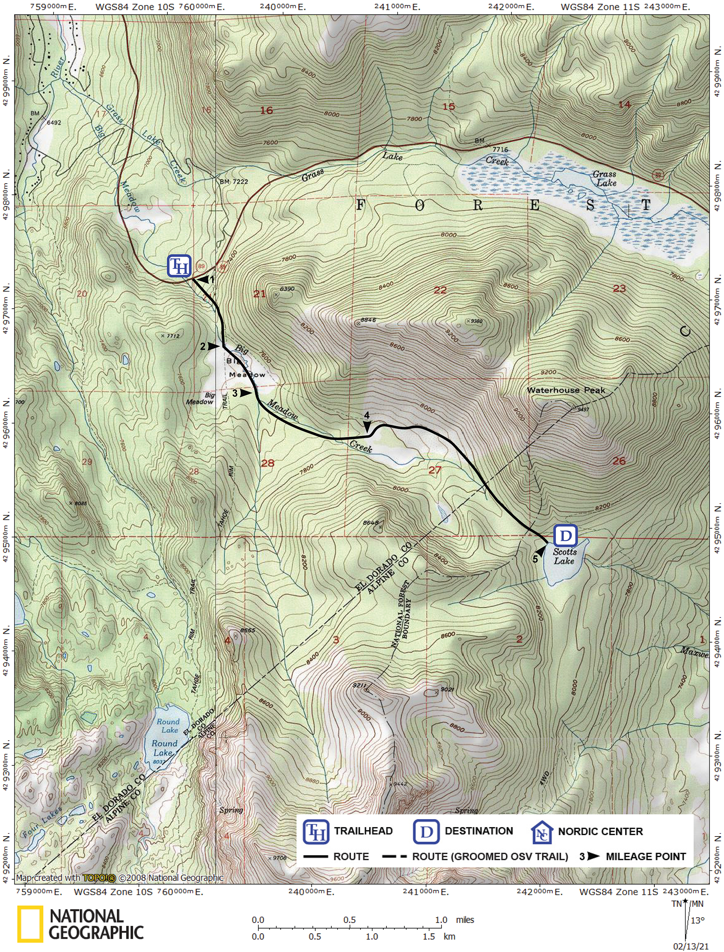
| Start | Highway 89, 5.0 miles south of Meyers. There is a turnout on the north side of the road. |
Description ![]()
This tour to Scotts Lake gives you the feeling of seclusion as you navigate through woods. It is a good choice for strong beginner-intermediate skiers who want to get away from the very easy-to-follow routes and experience an intermediate tour that requires more difficult route-finding.
The Hope Valley Via Big Meadow and Scotts Lake tour is a one-way variation of the tour described here; instead of retracing your route back to the trailhead it includes a wonderful downhill run with lots of room to maneuver as you descend from Scotts Lake to Hope Valley. It also eliminates the need to descend the relatively steep, often heavily worn, section from Big Meadow back to the trailhead. It does, however, require a shuttle vehicle.
Regardless of whether you retrace your route or ski one-way to Hope Valley, at Scotts Lake you will find yourself to the south of Waterhouse Peak, Hope Valley is to the east, and the horizon to the east is dominated by Pickett and Hawkins peaks.
Mileage Log ![]()
Numbers in parentheses
correspond to mileage points on map
Waypoint 1 to 2
Miles: 0.0 - 0.4
Elevation change: +300, -50 feet
Begin by locating the trailhead on the south side of the highway and 50 yards east (uphill) from where Big Meadow Creek crosses the highway. From the trailhead (1) ski south along the east (left) side of Big Meadow Creek for 0.4 mile until you reach Big Meadow (2). Stay far enough to the left of the creek to avoid the brush.
Waypoint 2 to 3
Miles: 0.4 - 0.8
Elevation change: +50 feet
Ski southeast (left) through the meadow for 0.4 mile until you reach the location where Big Meadow Creek enters the meadow (3).
Waypoint 3 to 4
Miles: 0.8 - 1.4
Elevation change: +250 feet
Enter the woods and ski along the creek for 0.6 mile until you reach another meadow (4).
Waypoint 4 to 5
Miles: 1.4 - 2.7
Elevation change: +300, -50 feet
Locate the road on the far north (left) side of the meadow and ski east and then southeast on the road for a total of 1.3 miles until you reach Scotts Lake (5).
Return to trailhead
Miles: 2.7 - 5.4
Elevation change: +100, -900 feet
Retrace the route for 2.7 miles back to the trailhead (1).