Summary ![]()
| Difficulty | 4 Intermediate-advanced |
| Length | 5.7 miles one-way |
| Starting Elevation |
7700 feet |
| Cumulative Elevation Change |
+1250, -2400 feet |
| Navigation | Map and compass |
| Time | Full day |
| Season | Late December through March |
| Snowmobiles Use | Low |
| USGS Topo | 7.5' series, Freel Peak, Echo Lake |
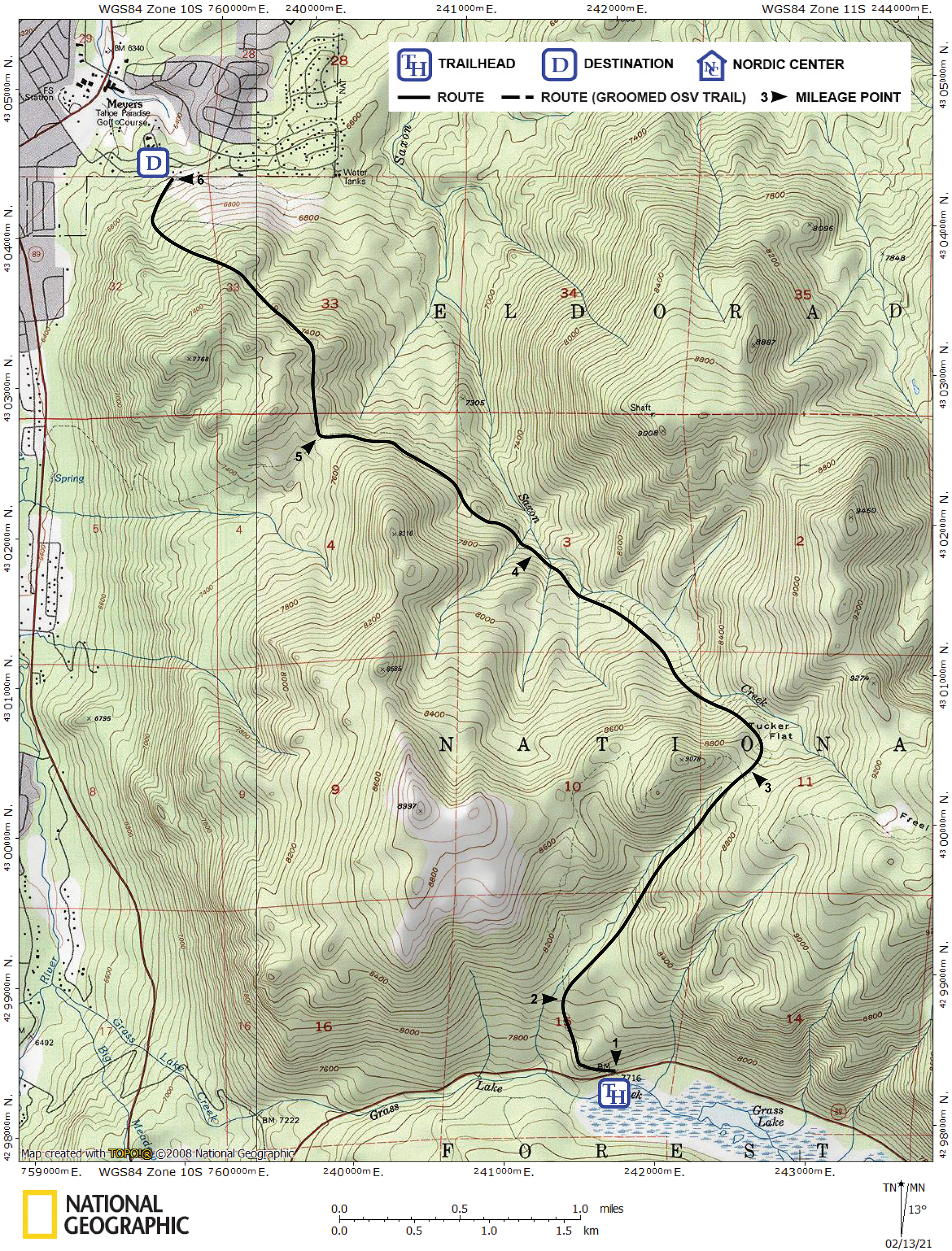
| Start | Highway 89, 6.8 miles south of Meyers at the turnout at the west end of Grass Lake. The tour begins on the north side of the road across from the turnout. |
| End | Tahoe Paradise residential area in Meyers. From Highway 50, follow Apache Avenue into the residential area and find a legal parking place; Lost Lane is a good location. Dense woods near the end of the tour make it difficult to end it at a specific point; carry a local map of the Meyers area on the tour so that you can find your car. |
Description ![]()
The beauty of this route is that long after the snow has thawed and consolidated in other areas, this route normally still offers powder snow conditions in the upper reaches of Saxon Creek. Coincidentally, this is the location of the downhill run from Tucker Flat.
This tour also challenges skiers — the terrain is steep, the navigation is critical, and the skiing in the dense woods is difficult.
Mileage Log ![]()
Numbers in parentheses
correspond to mileage points on map
Waypoint 1 to 2
Miles: 0.0 - 0.4
Elevation change: +300 feet
From the trailhead (1) ski west and then north for a total of 0.4 mile until you reach a creek (2).
Waypoint 2 to 3
Miles: 0.4 - 1.7
Elevation change: +800 feet
Climb northeast and parallel to the creek at a steep angle for 1.3 miles until you reach the saddle (3) to the east of Peak 9078. Only attempt this ascent when there is absolutely no avalanche danger. Tucker Flat is just to the northeast of the saddle.
Waypoint 3 to 4
Miles: 1.7 - 3.2
Elevation change: -1250 feet
Ski northeast to Tucker Flat and then descend northwest, paralleling but staying above the summer trail and Saxon Creek, for a total of 1.5 miles until you reach an elevation of 7600 feet (4). If you do not have an altimeter, you will have to estimate the correct elevation by carefully comparing the terrain with the topo. The descent in this section is steep, but hopefully covered with powder snow.
Waypoint 4 to 5
Miles: 3.2 - 4.3
Elevation change: -100 feet
Turn away from Saxon Creek and the summer trail, and traverse northwest below Peak 8316 and maintain elevation for 1.1 miles until you reach a level area at the end of a ridge (5).
Waypoint 5 to 6
Miles: 4.3 - 5.7
Elevation change: +150, -1050 feet
Traverse north and northwest for 0.8 mile and then descend northwest and north for 0.6 mile for a total of 1.4 miles until you reach the end point at Tahoe Paradise residential area (6). Be aware that if you drop down too early you end up in an undergrowth where it is impossible to ski.