Summary ![]()
| Difficulty | 2 Beginner-intermediate |
| Length | 1.4 miles round trip to Lake Audrian or 2.8 miles round trip to headwaters |
| Starting Elevation |
7250 feet |
| Cumulative Elevation Change |
+100, -100 feet to Lake Audrian or +300, -300 feet to headwaters |
| Navigation | Road, marked trail and map |
| Time | Few hours |
| Season | December through April |
| Snowmobiles Use | Low |
| USGS Topo | 7.5' series, Echo Lake |
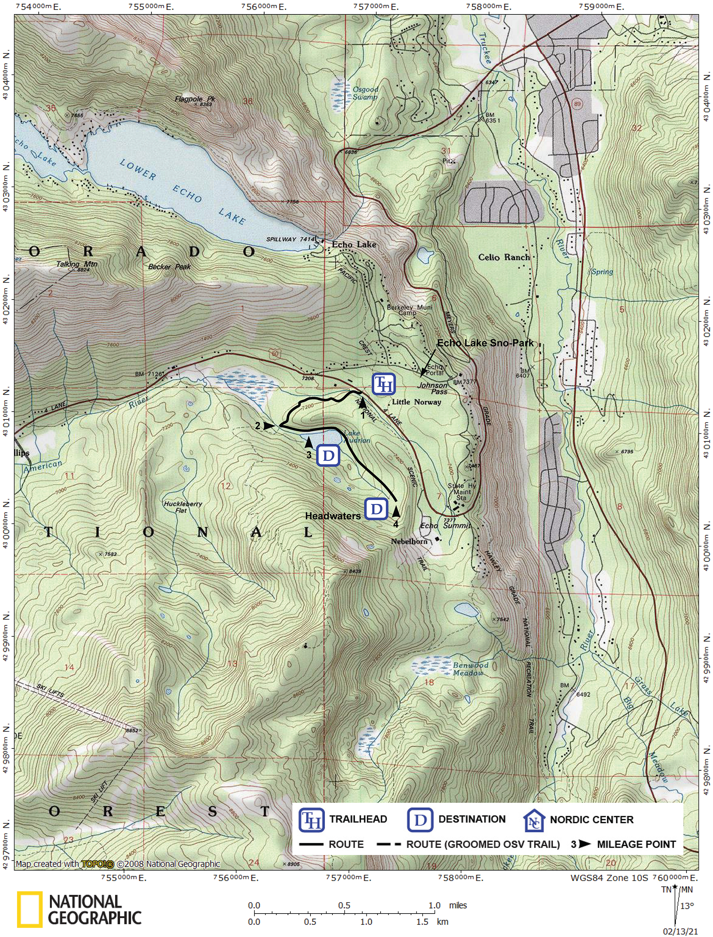
| Start | South side of Highway 50, 1.0 mile west of Echo Summit Maintenance Station and 0.2 mile east of Johnson Pass Road (the road to Berkeley Camp and Echo Lake Sno-Park). The trailhead is on the south side of the highway at a turnout where a snow-covered road is located. Park at the Echo Lake Sno-Park. From Highway 50 drive 0.6 mile east on Johnson Pass Road toward Berkeley Camp to the Sno-Park. To reach the trailhead from the Sno-Park, walk 0.6 mile down Johnson Pass Road to Highway 50, then 0.2 mile east on Highway 50, and finally cross to the south side of the highway where the trailhead is located. Be very careful when walking along Highway 50 and crossing it. As an alternative you can ski parallel to the highway. |
Description ![]()
Many, many years ago, Echo Nordic at Little Norway marked this route on which a few skiers would travel each weekend. Now that the center has closed shop (the original building at Little Norway has since burned too), the tour to the lake has almost been forgotten. As a result, you can be pretty much assured of being alone if you visit Lake Audrian.
The short tour to the Lake Audrian can be extended by continuing past it and exploring the headwaters of the lake.
The road you follow for the first part of the tour is marked with both blue diamonds and larger yellow diamonds placed there to guide the SnoCat drivers that service the microwave towers on the top of Huckleberry Ridge.
Mileage Log ![]()
Numbers in parentheses
correspond to mileage points on map
Waypoint 1 to 2
Miles: 0.0 - 0.6
Elevation change: -100 feet
From the trailhead (1) ski west on the road for 0.6 mile until you reach the creek (2) that drains Lake Audrian.
Waypoint 2 to 3
Miles: 0.6 - 0.7
Elevation change: Nil
Turn east (left), leave the road, and follow the creek for 0.1 mile until you reach Lake Audrian (3).
Return to trailhead
Miles: 0.7 - 1.4
Elevation change: +100
Retrace the route for 0.7 mile back to the trailhead (1) or continue to the headwaters of the lake.
To continue to the headwaters
Waypoint 3 to 4
Miles: 0.7 - 1.4
Elevation change: +200
To extend the tour, ski east along the north side of the lake and then southeast up the drainage for a total of an additional 0.7 mile until you reach the headwaters of Lake Audrian (4). At the headwaters, do not climb east to the top of the ridge unless you want your solitude to be shattered by the commercial snowplay area located near there.
Return to trailhead
Miles: 1.4 - 2.8
Elevation change: +100, -200
Retrace the route for 1.4 miles back to the trailhead (1).