Summary ![]()
| Difficulty | 1 Beginner |
| Length | 2.4 miles round trip |
| Starting Elevation |
8550 feet |
| Cumulative Elevation Change |
+200, -200 round trip |
| Navigation | Map |
| Time | Several hours |
| Season | Mid-December through April |
| Snowmobiles Use | Not permitted [Please report illegal use of snowmobiles in this area.] |
| USGS Topo | 7.5' series, Mount Rose |
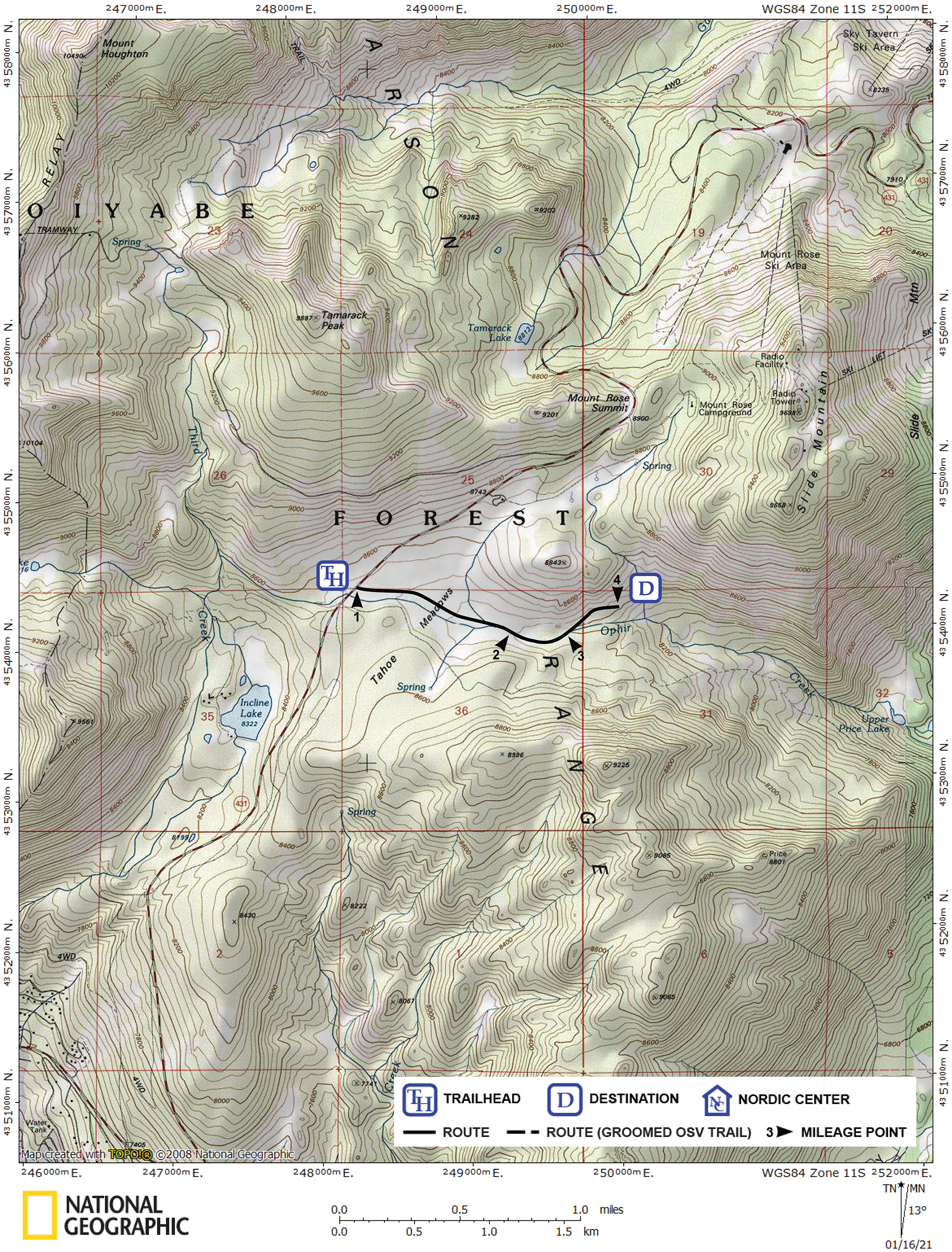
| Start | Highway 431, 6.6 miles northeast of Highway 28 and 1.5 miles southwest of Mount Rose Summit. This is where Ophir Creek intersects the highway and just north of the trees that border the south side of Tahoe Meadows. |
Description ![]()
The Ophir Creek tour descends east through Tahoe Meadows along the creek over terrain that is almost level. Although it is possible to continue farther along the creek, the tour described here ends where the creek begins to descend noticeably more steeply. This point gives an excellent view down the Ophir Creek drainage to Washoe Lake.

Looking down Ophir Creek (photo taken during drought)
An interesting extension of this tour is to combine it with an ascent of nearby Peak 8843 as described in the Ophir Creek and Peak 8843 tour.
Mileage Log ![]()
Numbers in parentheses
correspond to mileage points on map
Waypoint 1 to 2
Miles: 0.0 - 0.7
Elevation change: -100 feet
From the trailhead (1) ski east and then slightly south of east along Ophir Creek for a total of 0.7 mile until you reach trees that divide the path ahead into two possible routes (2), the obvious open one along the creek and the other one slightly to the north through scattered trees.

Cars line this popular trailhead
Waypoint 2 to 3
Miles: 0.7 - 1.0
Elevation change: -50 feet
Continue east along the creek for 0.3 mile until you reach the point where the route ahead is obviously better by veering slightly north and slightly up from the creek (3).
Waypoint 3 to 4
Miles: 1.0 - 1.2
Elevation change: -50 feet
Continue northeast along the north side of the creek and slightly above it for 0.2 mile until you reach the point where the creek drops abruptly as it continues east (4).
Return to trailhead
Miles: 1.2 - 2.4
Elevation change: +200 feet
Retrace the route for 1.2 miles back to the trailhead (1).