
Summary ![]()
| Difficulty | 4 Intermediate-advanced |
| Length | 12.6 miles round trip |
| Starting Elevation |
6300 feet |
| Cumulative Elevation Change |
+1250, -1250 feet |
| Navigation | Groomed trail, map and compass |
| Time | Very long day or two full days |
| Season | December through mid-April |
| Snowmobiles Use | Not permitted in Sugar Pine Point State Park. The west end of the Park is a short distance past the second bridge (mileage point 5). The use of snowmobiles in the upper reaches of General Creek is essentially zero, but their use near Richardson Lake and Ludlow Hut is moderate. [Please report illegal use of snowmobiles in this area.] |
| USGS Topo | 7.5' series, Meeks Bay, Homewood |
| Start | Sugar Pine Point State Park on Highway 89, 0.8 mile south of Tahoma. Turn west into the park and follow the road to the entrance station. Immediately past the entrance station turn left and follow the road a short distance to the day use parking lot and trailhead. Do not confuse this, the main part of the park, with the smaller part of the park located on the east side of Highway 89 and slightly farther south. |
Description ![]()
Most people visiting Ludlow Hut, situated near the shore of Richardson Lake, do so as part of a multi-day tour because it provides time to explore and enjoy the beauty of the area.
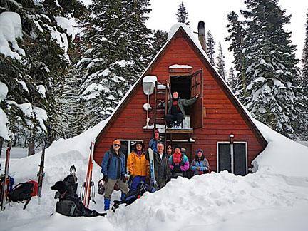
Ludlow Hut
The route described here to Richardson Lake and Ludlow Hut, beginning at Sugar Pine Point State Park and following General Creek, offers easy parking and miles of quiet backcountry skiing. It is, however, a significantly more difficult route than the one beginning at McKinney Creek where parking is exceptionally difficult and snowmobiles use the snow-covered road from the trailhead. An interesting one-way tour is created by combining the two tours.
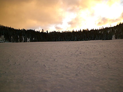
Sunset at Richardson Lake
This tour begins with more than two miles of groomed trail through Sugar Pine Point State Park. The easy going on this stretch tempers the tour which grows in difficulty as you leave the Park and enter the upper reaches of General Creek. At the head of General Creek you must climb out of the drainage and navigate with map and compass to the lake and hut.
Ludlow Hut, built by the Sierra Club in 1955, is located on the northern edge of Desolation Wilderness. It was built by friends and family as a memorial to Bill Ludlow who lost his life at the age of 23 while serving with the Army Corps of Engineers during the Korean War.
Although owned and operated by the Sierra Club, Ludlow Hut is open to the general public for use. The hut sleeps 15 on the upstairs wooden floor with cooking and eating space downstairs along with a wood heating stove. Make reservations to stay overnight at this Sierra Club hut by contacting:
Clair Tappaan Lodge
P.O. Box 36
Norden, CA 95724
530-426-3632 (phone)
800-679-6775 (toll free)
530-426-0742 (fax)
ctl@sierraclub.org
As one might expect, reservations for weekends and holidays are difficult to obtain. Volunteer for a summer or fall work party at one of the Sierra Club's huts to get reservation priority (contact Clair Tappaan Lodge for more information).
Sugar Pine Point State Park is open all winter for camping. Hot water and heated restrooms are provided in the campground, which is quiet during the winter months.
Mileage Log ![]()
Numbers in parentheses
correspond to mileage points on map
Waypoint 1 to 2
Miles: 0.0 - 0.4
Elevation change: Nil
From the trailhead (1) follow the groomed trail south and then west for a total of 0.4 mile until you reach a trail junction (2). The Blue Trail is to the north (right).
Waypoint 2 to 3
Miles: 0.4 - 1.0
Elevation change: +50 feet
Continue west (straight) on the groomed trail for 0.6 mile until you reach a trail junction (3). Again to the north is the Blue Trail.
Waypoint 3 to 4
Miles: 1.0 - 1.4
Elevation change: +50, -50 feet
Continue west (left) on the groomed trail for 0.4 mile until you reach a trail junction (4). To the southeast (left) is the first bridge across General Creek.
Waypoint 4 to 5
Miles: 1.4 - 2.3
Elevation change: +100 feet
Follow the groomed trail southwest (straight) for 0.9 mile until you reach a location just to the north of the second bridge (5) across General Creek. In this section you may encounter several other groomed trails. The route you want is the one that parallels the creek to the southwest and has very little elevation change. It should be obvious.
Waypoint 5 to 6
Miles: 2.3 - 4.2
Elevation change: +200 feet
Leave the groomed trail and ski generally southwest along the north side of General creek for 1.9 miles until the slope to the north hems you in along General Creek (6). This point is a short distance west of where the creek draining Lost and Duck lakes meets General Creek.
Waypoint 6 to 7
Miles: 4.2 - 5.5
Elevation change: +550 feet
Cross to the south side of General Creek and continue skiing slightly south of west for 1.3 miles until you reach the head of General Creek (7) and can see a moderate route ahead to the northwest. Traveling in this section can be very slow in low snow conditions. The location of where you cross to the south side of the creek is not critical, but at some point you will find it necessary.
Waypoint 7 to 8
Miles: 5.5 - 6.3
Elevation change: +250 feet
Ascend northwest out of the General Creek drainage toward a very broad saddle and then ski west for a total of 0.8 miles until you reach Ludlow Hut (8). An alternative is to cross back to the north side of General Creek approximately where the summer trail crosses back to the north side, and then ascend out of the drainage approximately where the summer trails lies. Avoid any slopes that are unstable if you choose that route. Ludlow Hut is located about 100 yards east of Richardson Lake and slightly above it.
Return to trailhead
Miles: 6.3 - 12.6
Elevation change: -1250 feet
Retrace the route for 6.3 miles back to the trailhead (1).
