Summary ![]()
| Difficulty | 5 Advanced |
| Length | 7.2 miles one-way |
| Starting Elevation |
6000 feet |
| Cumulative Elevation Change |
+1950, -1950 one-way |
| Navigation | Road and map |
| Time | Most of a day |
| Season | Late December through mid-April |
| Snowmobiles Use | Not permitted except for private landowner who can ride up Deep Creek on the road to access his land. [Please report illegal use of snowmobiles in this area.] |
| USGS Topo | 7.5' series, Tahoe City, Truckee |
| Start | Highway 89 at the intersection with the Pole Creek road, 6.2 miles south of Interstate 80, 7.5 miles north of Tahoe City, and immediately south of Pole Creek. |
| End | Highway 89 at the intersection with the Deep Creek road, 4.7 miles south of Interstate 80, 9.0 miles north of Tahoe City, and 1.5 miles north of starting point at Pole Creek. See the description below for more information about the ending point. |
Description ![]()
The 1100-foot descent from a ridgetop into the Deep Creek drainage is the main reason for skiing this tour. Although the descent is on a north-facing slope, the powder here turns to mush quickly due to the relatively low elevation; you might want to pick a nice day with spring-like conditions to do this tour.
A trip to Bradley Hut can be combined with the descent described here by following the Bradley Hut Loop tour to the point where you descend from the ridge into the Deep Creek drainage. Another descent into the Deep Creek Drainage is described in the Bradley Hut and Deep Creek tour.
Refer to the Bradley Hut tour for information on hut reservations.
Regardless of whether you ski the tour described here or the Bradley Hut and Deep Creek tour, the logistics are difficult because there is no parking available at the ending point. Unless the snow has melted off part of the Deep Creek road or the private landowner up Deep Creek has plowed parking on the road, your only option is to walk 1.5 miles south back to the starting point.
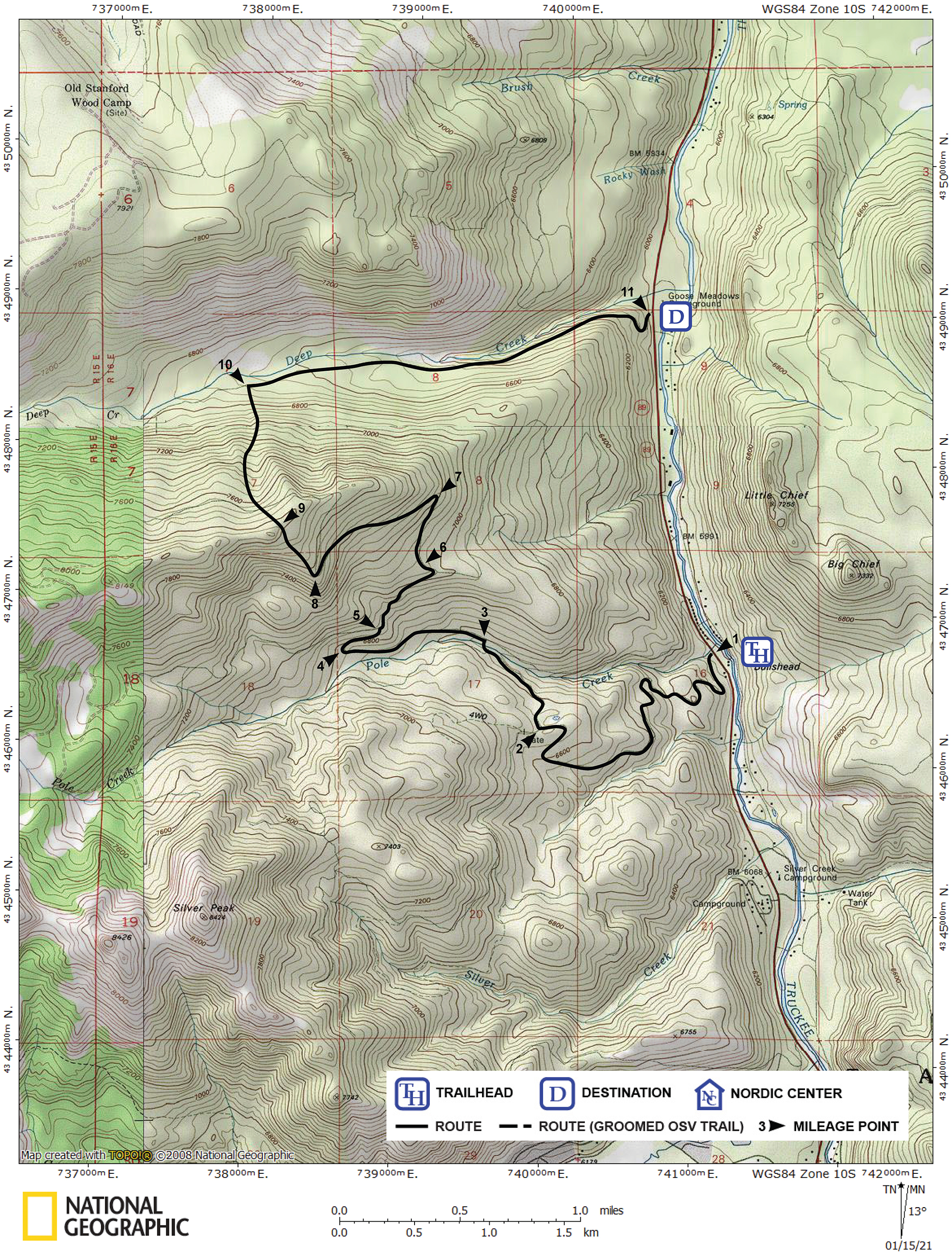
Mileage Log ![]()
Numbers in parentheses
correspond to mileage points on map
Waypoint 1 to 2
Miles: 0.0 - 1.9
Elevation change: +650 feet
From the trailhead (1) ascend generally east on the convoluted snow-covered road for 1.9 miles until you reach a road junction (2). The road to the west (left) is part of the Saddle Trail Loop and the Silver Peak tours. The tour to Bradley Hut continues north (straight) on the main road.
Waypoint 2 to 3
Miles: 1.9 - 2.4
Elevation change: +50, -150 feet
Continue north (straight) on the main road, then northwest and finally cross Pole Creek on a bridge for a total of 0.5 mile until you reach a road junction (3). The road to the east (right) is part of the Pole Creek Loop tour and leads back to Highway 89. The road to the west (left) leads to Bradley Hut.
Waypoint 3 to 4
Miles: 2.4 - 3.0
Elevation change: +200 feet
Turn west (left) and follow the road for 0.6 mile until you reach a 180-degree turn to the right (4).
Waypoint 4 to 5
Miles: 3.0 - 3.2
Elevation change: +100 feet
Make the turn and continue on the road to the east for 0.2 mile until you reach a road junction (5) where the main road turns 180 degrees to the left and heads west to Bradley Hut. The tour described here continues on the road to the north.
Waypoint 5 to 6
Miles: 3.2 - 3.6
Elevation change: +200 feet
Take the lesser road to the north and ski northeast for 0.4 mile until you reach more level terrain on a broad ridge (6).
Waypoint 6 to 7
Miles: 3.6 - 3.9
Elevation change: +150 feet
Locate where the road continues (it may not be obvious) and follow it north for 0.3 mile to where it makes a sharp turn (7). This is the first of two sharp turns.
Waypoint 7 to 8
Miles: 3.9 - 4.5
Elevation change: +350 feet
Make the turn to the left and continue southwest up the road for 0.6 mile until you reach a second sharp turn (8).
Waypoint 8 to 9
Miles: 4.5 - 4.8
Elevation change: +250 feet
Leave the road and climb northwest for 0.3 mile until you reach the ridgetop (9).
Waypoint 9 to 10
Miles: 4.8 - 5.5
Elevation change: -1100 feet
Descend north for 0.7 mile until you reach the road that parallels Deep Creek (10). A good route to descend is located to the west of a small spur that heads north from the ridge.
Waypoint 10 to 11
Miles: 5.5 - 7.2
Elevation change: -700 feet
Turn east (right) and follow the road for 1.7 miles until you reach Highway 89 (11).