Summary ![]()
| Difficulty | 1-3 Beginner to intermediate |
| Length | Up to 7.4 miles round trip |
| Starting Elevation |
5850 feet |
| Cumulative Elevation Change |
Up to+ 1300, -1300 round trip |
| Navigation | Road, marked trail and map |
| Time | Up to full day |
| Season | December through mid-April |
| Snowmobiles Use | Not permitted [Please report illegal use of snowmobiles in this area.] |
| USGS Topo | 7.5' series, Manzanita Lake, Lassen Peak |
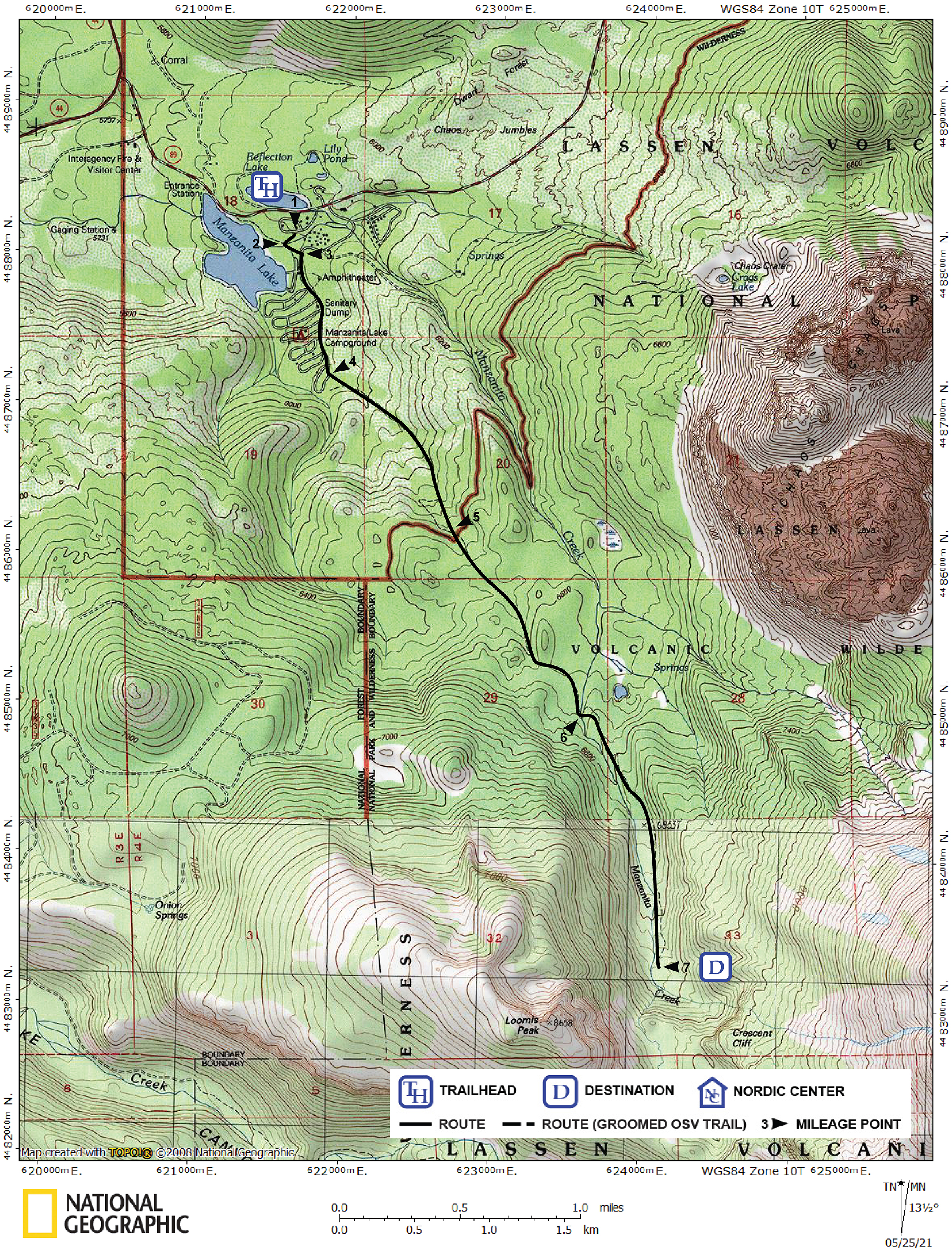
| Start | Manzanita Lake Ranger Station, 0.5 mile east of the Manzanita Lake Entrance Station. The ranger station is closed in winter. |
Description ![]()
Away from the main road, Manzanita Creek Trail allows you to enjoy the feeling of being in the backwoods alone and away from the trappings of man. You will have a close-up view of Lassen and Loomis Peaks at the mid-point of the tour, and a view of the sheer walls of Crescent Cliff at the far point of the tour, but they will not be panoramic views.
The first 1.6 miles of the tour to the south end of Manzanita Lake Campground are very easy and suitable for first time skiers. Once you reach the campground you can continue on the Manzanita Creek Trail that is described here or simply ski around in the campground before returning to the trailhead.
Beyond the campground Manzanita Creek Trail climbs 1200 feet to the base of Crescent Cliff. It is a steady climb the whole distance though after 0.9 mile of climbing there is some respite.
Snow campers will find good sites along the upper section of Manzanita Creek Trail where running water can be found. However, be aware that it is not safe to camp, or for that matter ski, in some areas close to Loomis Peak.
The Manzanita Creek Trail is also part of the Crescent Cliff Traverse, which is the shortest ski route between the Manzanita Lake and Southwest entrances to the park.
Mileage Log ![]()
Numbers in parentheses
correspond to mileage points on map
Waypoint 1 to 2
Miles: 0.0 - 0.1
Elevation change: +0
From the trailhead (1) ski southwest for 0.1 mile until you reach the bridge (2) across the inlet to Manzanita Lake.
Waypoint 2 to 3
Miles: 0.1 - 0.2
Elevation change: +0
Ski southeast (left) for 0.1 mile until you reach the campground road (3).
Waypoint 3 to 4
Miles: 0.2 - 0.7
Elevation change: +100
Turn south (right) onto the campground road and continue for 0.5 mile until you reach the south end of the campground and the sign marking the beginning of the Manzanita Creek Trail (4).
Waypoint 4 to 5
Miles: 0.7 - 1.6
Elevation change: +450
Climb southeast for 0.9 mile until you reach the point where the terrain distinctly levels (5).
Waypoint 5 to 6
Miles: 1.6 - 2.5
Elevation change: +300
Continue to climb to the southeast, but at a reduced slope, for 0.9 mile until you reach a bridge (6) across the Manzanita Creek.
Waypoint 6 to 7
Miles: 2.5 - 3.7
Elevation change: +450
Continue to climb south for 1.2 miles until you reach the headwaters of Manzanita Creek (7). At the head of the canyon you will see the sheer walls of Crescent Cliff above. Also, the slopes that descend from Loomis Peak are subject to avalanche.
Return to trailhead
Miles: 3.7 - 7.4
Elevation change: -1300
Retrace the route for 3.7 miles back to the trailhead (1).